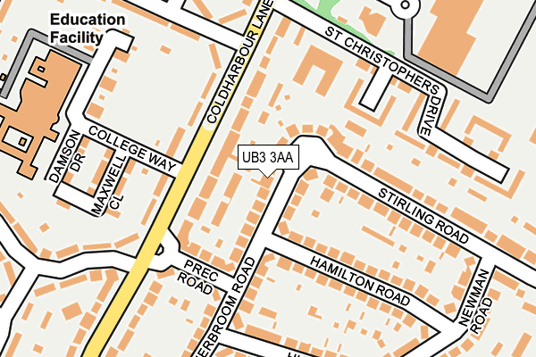
UB3 3AA lies on Hitherbroom Road in Hayes. UB3 3AA is located in the Wood End electoral ward, within the London borough of Hillingdon and the English Parliamentary constituency of Hayes and Harlington. The Sub Integrated Care Board (ICB) Location is NHS North West London ICB - W2U3Z and the police force is Metropolitan Police. This postcode has been in use since January 1980.


GetTheData
Source: OS OpenMap – Local (Ordnance Survey)
Source: OS VectorMap District (Ordnance Survey)
Licence: Open Government Licence (requires attribution)
| Easting | 510520 |
| Northing | 180746 |
| Latitude | 51.514837 |
| Longitude | -0.408661 |
GetTheData
Source: Open Postcode Geo
Licence: Open Government Licence
| Street | Hitherbroom Road |
| Town/City | Hayes |
| Country | England |
| Postcode District | UB3 |
➜ See where UB3 is on a map ➜ Where is Hayes? | |
GetTheData
Source: Land Registry Price Paid Data
Licence: Open Government Licence
Elevation or altitude of UB3 3AA as distance above sea level:
| Metres | Feet | |
|---|---|---|
| Elevation | 30m | 98ft |
Elevation is measured from the approximate centre of the postcode, to the nearest point on an OS contour line from OS Terrain 50, which has contour spacing of ten vertical metres.
➜ How high above sea level am I? Find the elevation of your current position using your device's GPS.
GetTheData
Source: Open Postcode Elevation
Licence: Open Government Licence
| Ward | Wood End |
| Constituency | Hayes And Harlington |
GetTheData
Source: ONS Postcode Database
Licence: Open Government Licence
| Hesa Road (Coldharbour Lane) | Wood End | 60m |
| Precinct Road | Hayes Town | 123m |
| Precinct Road | Hayes Town | 149m |
| Hesa Road (Coldharbour Lane) | Wood End | 177m |
| Lombardy Retail Park | Wood End | 230m |
| Hayes & Harlington Station | 1.6km |
| Southall Station | 2.3km |
| West Drayton Station | 4.4km |
GetTheData
Source: NaPTAN
Licence: Open Government Licence
| Percentage of properties with Next Generation Access | 100.0% |
| Percentage of properties with Superfast Broadband | 100.0% |
| Percentage of properties with Ultrafast Broadband | 100.0% |
| Percentage of properties with Full Fibre Broadband | 0.0% |
Superfast Broadband is between 30Mbps and 300Mbps
Ultrafast Broadband is > 300Mbps
| Median download speed | 77.9Mbps |
| Average download speed | 76.4Mbps |
| Maximum download speed | 200.00Mbps |
| Median upload speed | 14.1Mbps |
| Average upload speed | 11.0Mbps |
| Maximum upload speed | 20.00Mbps |
| Percentage of properties unable to receive 2Mbps | 0.0% |
| Percentage of properties unable to receive 5Mbps | 0.0% |
| Percentage of properties unable to receive 10Mbps | 0.0% |
| Percentage of properties unable to receive 30Mbps | 0.0% |
GetTheData
Source: Ofcom
Licence: Ofcom Terms of Use (requires attribution)
Estimated total energy consumption in UB3 3AA by fuel type, 2015.
| Consumption (kWh) | 467,862 |
|---|---|
| Meter count | 26 |
| Mean (kWh/meter) | 17,995 |
| Median (kWh/meter) | 17,931 |
| Consumption (kWh) | 107,072 |
|---|---|
| Meter count | 26 |
| Mean (kWh/meter) | 4,118 |
| Median (kWh/meter) | 3,803 |
GetTheData
Source: Postcode level gas estimates: 2015 (experimental)
Source: Postcode level electricity estimates: 2015 (experimental)
Licence: Open Government Licence
GetTheData
Source: ONS Postcode Database
Licence: Open Government Licence


➜ Get more ratings from the Food Standards Agency
GetTheData
Source: Food Standards Agency
Licence: FSA terms & conditions
| Last Collection | |||
|---|---|---|---|
| Location | Mon-Fri | Sat | Distance |
| Warley Road | 19:00 | 13:00 | 794m |
| Shaftesbury Way | 17:00 | 13:00 | 938m |
| Warley Road | 18:45 | 13:00 | 1,032m |
GetTheData
Source: Dracos
Licence: Creative Commons Attribution-ShareAlike
The below table lists the International Territorial Level (ITL) codes (formerly Nomenclature of Territorial Units for Statistics (NUTS) codes) and Local Administrative Units (LAU) codes for UB3 3AA:
| ITL 1 Code | Name |
|---|---|
| TLI | London |
| ITL 2 Code | Name |
| TLI7 | Outer London - West and North West |
| ITL 3 Code | Name |
| TLI74 | Harrow and Hillingdon |
| LAU 1 Code | Name |
| E09000017 | Hillingdon |
GetTheData
Source: ONS Postcode Directory
Licence: Open Government Licence
The below table lists the Census Output Area (OA), Lower Layer Super Output Area (LSOA), and Middle Layer Super Output Area (MSOA) for UB3 3AA:
| Code | Name | |
|---|---|---|
| OA | E00012462 | |
| LSOA | E01002501 | Hillingdon 026B |
| MSOA | E02000519 | Hillingdon 026 |
GetTheData
Source: ONS Postcode Directory
Licence: Open Government Licence
| UB3 3HH | Coldharbour Lane | 66m |
| UB3 3AB | Hitherbroom Road | 99m |
| UB3 3AQ | Stirling Road | 103m |
| UB3 3EH | Coldharbour Lane | 114m |
| UB3 3HJ | Coldharbour Lane | 116m |
| UB3 3AR | Hamilton Road | 118m |
| UB3 3AG | Precinct Road | 142m |
| UB3 3AD | Hitherbroom Road | 158m |
| UB3 3AH | Stirling Road | 172m |
| UB3 3AS | Hamilton Road | 195m |
GetTheData
Source: Open Postcode Geo; Land Registry Price Paid Data
Licence: Open Government Licence