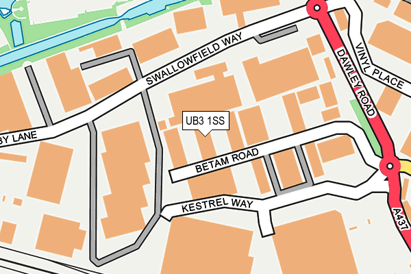
UB3 1SS is located in the Hayes Town electoral ward, within the London borough of Hillingdon and the English Parliamentary constituency of Hayes and Harlington. The Sub Integrated Care Board (ICB) Location is NHS North West London ICB - W2U3Z and the police force is Metropolitan Police. This postcode has been in use since October 1984.


GetTheData
Source: OS OpenMap – Local (Ordnance Survey)
Source: OS VectorMap District (Ordnance Survey)
Licence: Open Government Licence (requires attribution)
| Easting | 508714 |
| Northing | 179801 |
| Latitude | 51.506693 |
| Longitude | -0.434969 |
GetTheData
Source: Open Postcode Geo
Licence: Open Government Licence
| Country | England |
| Postcode District | UB3 |
➜ See where UB3 is on a map ➜ Where is Hayes? | |
GetTheData
Source: Land Registry Price Paid Data
Licence: Open Government Licence
Elevation or altitude of UB3 1SS as distance above sea level:
| Metres | Feet | |
|---|---|---|
| Elevation | 30m | 98ft |
Elevation is measured from the approximate centre of the postcode, to the nearest point on an OS contour line from OS Terrain 50, which has contour spacing of ten vertical metres.
➜ How high above sea level am I? Find the elevation of your current position using your device's GPS.
GetTheData
Source: Open Postcode Elevation
Licence: Open Government Licence
| Ward | Hayes Town |
| Constituency | Hayes And Harlington |
GetTheData
Source: ONS Postcode Database
Licence: Open Government Licence
| Swallowfield Way (Dawley Road) | Hayes Town | 225m |
| Swallowfield Way (Dawley Road) | Hayes Town | 256m |
| Blyth Road (Dawley Road) | Hayes Town | 321m |
| Stockley Park Eastthe Square | Stockley Park | 326m |
| Stockley Park Eastthe Square | Stockley Park | 372m |
| Hayes & Harlington Station | 1.1km |
| West Drayton Station | 2.6km |
| Southall Station | 3.9km |
GetTheData
Source: NaPTAN
Licence: Open Government Licence
| Median download speed | 11.9Mbps |
| Average download speed | 12.7Mbps |
| Maximum download speed | 18.68Mbps |
| Median upload speed | 1.0Mbps |
| Average upload speed | 1.0Mbps |
| Maximum upload speed | 1.17Mbps |
GetTheData
Source: Ofcom
Licence: Ofcom Terms of Use (requires attribution)
Estimated total energy consumption in UB3 1SS by fuel type, 2015.
| Consumption (kWh) | 219,330 |
|---|---|
| Meter count | 19 |
| Mean (kWh/meter) | 11,544 |
| Median (kWh/meter) | 437 |
GetTheData
Source: Postcode level gas estimates: 2015 (experimental)
Source: Postcode level electricity estimates: 2015 (experimental)
Licence: Open Government Licence
GetTheData
Source: ONS Postcode Database
Licence: Open Government Licence


➜ Get more ratings from the Food Standards Agency
GetTheData
Source: Food Standards Agency
Licence: FSA terms & conditions
| Last Collection | |||
|---|---|---|---|
| Location | Mon-Fri | Sat | Distance |
| Princes Park Lane | 17:30 | 13:15 | 98m |
| Swallowfield Way | 18:45 | 304m | |
| Bourne Avenue | 16:45 | 13:00 | 800m |
GetTheData
Source: Dracos
Licence: Creative Commons Attribution-ShareAlike
The below table lists the International Territorial Level (ITL) codes (formerly Nomenclature of Territorial Units for Statistics (NUTS) codes) and Local Administrative Units (LAU) codes for UB3 1SS:
| ITL 1 Code | Name |
|---|---|
| TLI | London |
| ITL 2 Code | Name |
| TLI7 | Outer London - West and North West |
| ITL 3 Code | Name |
| TLI74 | Harrow and Hillingdon |
| LAU 1 Code | Name |
| E09000017 | Hillingdon |
GetTheData
Source: ONS Postcode Directory
Licence: Open Government Licence
The below table lists the Census Output Area (OA), Lower Layer Super Output Area (LSOA), and Middle Layer Super Output Area (MSOA) for UB3 1SS:
| Code | Name | |
|---|---|---|
| OA | E00011976 | |
| LSOA | E01002406 | Hillingdon 027B |
| MSOA | E02000520 | Hillingdon 027 |
GetTheData
Source: ONS Postcode Directory
Licence: Open Government Licence
| UB3 1DQ | Swallowfield Way | 54m |
| UB3 1ST | Adler Industrial Estate | 123m |
| UB3 1EQ | U K Cottages | 210m |
| UB3 1EY | Rigby Lane | 229m |
| UB11 1ET | The Square | 278m |
| UB3 1EL | Orchard Cottages | 312m |
| UB3 1RB | Burnham Gardens | 349m |
| UB3 1RQ | Stormount Drive | 355m |
| UB3 1EH | Dawley Road | 362m |
| UB3 1EN | Dawley Road | 367m |
GetTheData
Source: Open Postcode Geo; Land Registry Price Paid Data
Licence: Open Government Licence