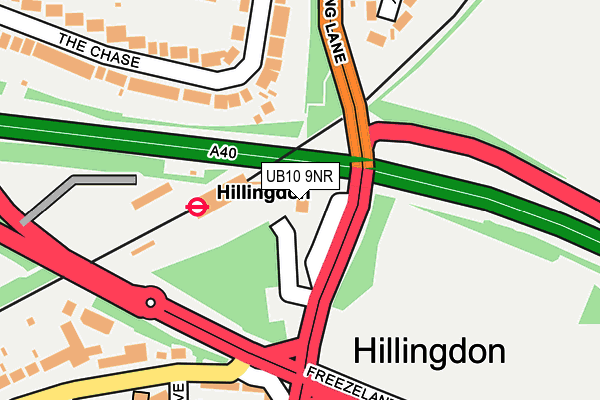
UB10 9NR is located in the Hillingdon East electoral ward, within the London borough of Hillingdon and the English Parliamentary constituency of Uxbridge and South Ruislip. The Sub Integrated Care Board (ICB) Location is NHS North West London ICB - W2U3Z and the police force is Metropolitan Police. This postcode has been in use since January 1980.


GetTheData
Source: OS OpenMap – Local (Ordnance Survey)
Source: OS VectorMap District (Ordnance Survey)
Licence: Open Government Licence (requires attribution)
| Easting | 507646 |
| Northing | 185010 |
| Latitude | 51.553718 |
| Longitude | -0.448740 |
GetTheData
Source: Open Postcode Geo
Licence: Open Government Licence
| Country | England |
| Postcode District | UB10 |
➜ See where UB10 is on a map | |
GetTheData
Source: Land Registry Price Paid Data
Licence: Open Government Licence
Elevation or altitude of UB10 9NR as distance above sea level:
| Metres | Feet | |
|---|---|---|
| Elevation | 40m | 131ft |
Elevation is measured from the approximate centre of the postcode, to the nearest point on an OS contour line from OS Terrain 50, which has contour spacing of ten vertical metres.
➜ How high above sea level am I? Find the elevation of your current position using your device's GPS.
GetTheData
Source: Open Postcode Elevation
Licence: Open Government Licence
| Ward | Hillingdon East |
| Constituency | Uxbridge And South Ruislip |
GetTheData
Source: ONS Postcode Database
Licence: Open Government Licence
| Hillingdon Station (Long Lane) | North Hillingdon | 31m |
| Hillingdon Station (Long Lane) | North Hillingdon | 34m |
| Hillingdon Station | North Hillingdon | 45m |
| Hillingdon Circus (.) | North Hillingdon | 235m |
| Auriol Drive (Ub10) | North Hillingdon | 236m |
| Hillingdon Underground Station | North Hillingdon | 74m |
| Ickenham Underground Station | Ickenham | 1,033m |
| West Ruislip Station | 1.9km |
| South Ruislip Station | 3.5km |
| Denham Station | 4.4km |
GetTheData
Source: NaPTAN
Licence: Open Government Licence
GetTheData
Source: ONS Postcode Database
Licence: Open Government Licence


➜ Get more ratings from the Food Standards Agency
GetTheData
Source: Food Standards Agency
Licence: FSA terms & conditions
| Last Collection | |||
|---|---|---|---|
| Location | Mon-Fri | Sat | Distance |
| Copthall Road East | 18:00 | 12:45 | 161m |
| North Hillingdon Post Office | 19:00 | 12:00 | 311m |
| Parkfield Avenue | 18:00 | 12:45 | 420m |
GetTheData
Source: Dracos
Licence: Creative Commons Attribution-ShareAlike
The below table lists the International Territorial Level (ITL) codes (formerly Nomenclature of Territorial Units for Statistics (NUTS) codes) and Local Administrative Units (LAU) codes for UB10 9NR:
| ITL 1 Code | Name |
|---|---|
| TLI | London |
| ITL 2 Code | Name |
| TLI7 | Outer London - West and North West |
| ITL 3 Code | Name |
| TLI74 | Harrow and Hillingdon |
| LAU 1 Code | Name |
| E09000017 | Hillingdon |
GetTheData
Source: ONS Postcode Directory
Licence: Open Government Licence
The below table lists the Census Output Area (OA), Lower Layer Super Output Area (LSOA), and Middle Layer Super Output Area (MSOA) for UB10 9NR:
| Code | Name | |
|---|---|---|
| OA | E00012505 | |
| LSOA | E01002513 | Hillingdon 013D |
| MSOA | E02000506 | Hillingdon 013 |
GetTheData
Source: ONS Postcode Directory
Licence: Open Government Licence
| UB10 8ST | The Chase | 162m |
| UB10 8QR | Bridge Way | 224m |
| UB10 9JU | Long Lane | 229m |
| UB10 9PQ | Western Parade | 229m |
| UB10 9PP | Magnolia Court | 256m |
| UB10 9NA | Hercies Road | 268m |
| UB10 9PG | Long Lane | 271m |
| UB10 8PY | Halford Road | 275m |
| UB10 8SS | The Chase | 282m |
| UB10 8SU | Long Lane | 289m |
GetTheData
Source: Open Postcode Geo; Land Registry Price Paid Data
Licence: Open Government Licence