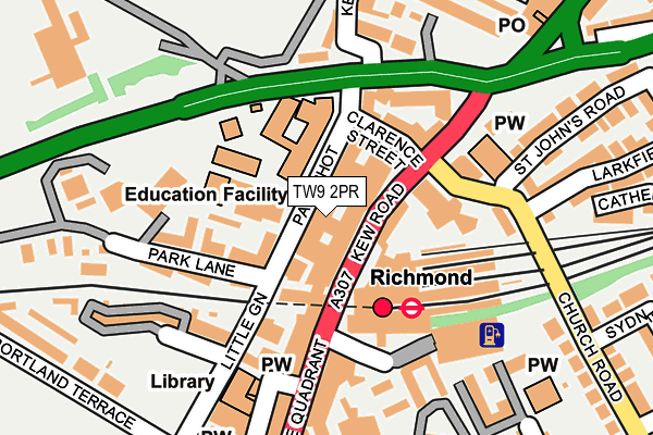
TW9 2PR is located in the South Richmond electoral ward, within the London borough of Richmond upon Thames and the English Parliamentary constituency of Richmond Park. The Sub Integrated Care Board (ICB) Location is NHS South West London ICB - 36L and the police force is Metropolitan Police. This postcode has been in use since December 1997.


GetTheData
Source: OS OpenMap – Local (Ordnance Survey)
Source: OS VectorMap District (Ordnance Survey)
Licence: Open Government Licence (requires attribution)
| Easting | 518020 |
| Northing | 175227 |
| Latitude | 51.463720 |
| Longitude | -0.302470 |
GetTheData
Source: Open Postcode Geo
Licence: Open Government Licence
| Country | England |
| Postcode District | TW9 |
➜ See where TW9 is on a map ➜ Where is Richmond upon Thames? | |
GetTheData
Source: Land Registry Price Paid Data
Licence: Open Government Licence
Elevation or altitude of TW9 2PR as distance above sea level:
| Metres | Feet | |
|---|---|---|
| Elevation | 10m | 33ft |
Elevation is measured from the approximate centre of the postcode, to the nearest point on an OS contour line from OS Terrain 50, which has contour spacing of ten vertical metres.
➜ How high above sea level am I? Find the elevation of your current position using your device's GPS.
GetTheData
Source: Open Postcode Elevation
Licence: Open Government Licence
| Ward | South Richmond |
| Constituency | Richmond Park |
GetTheData
Source: ONS Postcode Database
Licence: Open Government Licence
| Richmond Station | Richmond | 52m |
| Richmond Station | Richmond | 53m |
| Richmond Station | Richmond | 57m |
| Richmond Station | Richmond | 72m |
| Richmond Station | Richmond | 81m |
| Richmond Underground Station | Richmond | 95m |
| Richmond (London) Station | 0.1km |
| North Sheen Station | 1km |
| St Margarets (London) Station | 1.6km |
GetTheData
Source: NaPTAN
Licence: Open Government Licence
GetTheData
Source: ONS Postcode Database
Licence: Open Government Licence


➜ Get more ratings from the Food Standards Agency
GetTheData
Source: Food Standards Agency
Licence: FSA terms & conditions
| Last Collection | |||
|---|---|---|---|
| Location | Mon-Fri | Sat | Distance |
| Parkshot, Kew Road | 18:30 | 11:30 | 71m |
| Richmond Station, The Quadrant | 18:30 | 11:30 | 72m |
| Friston House, Church Road | 18:30 | 11:00 | 245m |
GetTheData
Source: Dracos
Licence: Creative Commons Attribution-ShareAlike
The below table lists the International Territorial Level (ITL) codes (formerly Nomenclature of Territorial Units for Statistics (NUTS) codes) and Local Administrative Units (LAU) codes for TW9 2PR:
| ITL 1 Code | Name |
|---|---|
| TLI | London |
| ITL 2 Code | Name |
| TLI7 | Outer London - West and North West |
| ITL 3 Code | Name |
| TLI75 | Hounslow and Richmond upon Thames |
| LAU 1 Code | Name |
| E09000027 | Richmond upon Thames |
GetTheData
Source: ONS Postcode Directory
Licence: Open Government Licence
The below table lists the Census Output Area (OA), Lower Layer Super Output Area (LSOA), and Middle Layer Super Output Area (MSOA) for TW9 2PR:
| Code | Name | |
|---|---|---|
| OA | E00019508 | |
| LSOA | E01003876 | Richmond upon Thames 008B |
| MSOA | E02000791 | Richmond upon Thames 008 |
GetTheData
Source: ONS Postcode Directory
Licence: Open Government Licence
| TW9 2RG | Parkshot | 57m |
| TW9 2RD | Parkshot | 64m |
| TW9 1DL | The Quadrant | 67m |
| TW9 2NQ | Kew Road | 69m |
| TW9 2SA | Clarence Street | 84m |
| TW9 2SD | Twickenham Road | 119m |
| TW9 2NA | Kew Road | 131m |
| TW9 2RB | The Gateways | 142m |
| TW9 2RA | Park Lane | 157m |
| TW9 1DN | The Quadrant | 162m |
GetTheData
Source: Open Postcode Geo; Land Registry Price Paid Data
Licence: Open Government Licence