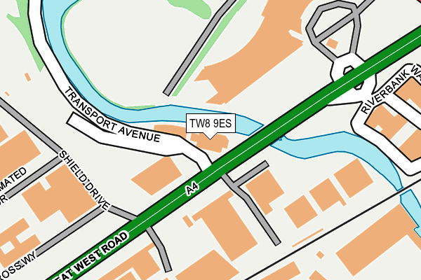
TW8 9ES is located in the Osterley & Spring Grove electoral ward, within the London borough of Hounslow and the English Parliamentary constituency of Brentford and Isleworth. The Sub Integrated Care Board (ICB) Location is NHS North West London ICB - W2U3Z and the police force is Metropolitan Police. This postcode has been in use since September 1991.


GetTheData
Source: OS OpenMap – Local (Ordnance Survey)
Source: OS VectorMap District (Ordnance Survey)
Licence: Open Government Licence (requires attribution)
| Easting | 516862 |
| Northing | 177761 |
| Latitude | 51.486734 |
| Longitude | -0.318294 |
GetTheData
Source: Open Postcode Geo
Licence: Open Government Licence
| Country | England |
| Postcode District | TW8 |
➜ See where TW8 is on a map ➜ Where is Brentford? | |
GetTheData
Source: Land Registry Price Paid Data
Licence: Open Government Licence
Elevation or altitude of TW8 9ES as distance above sea level:
| Metres | Feet | |
|---|---|---|
| Elevation | 10m | 33ft |
Elevation is measured from the approximate centre of the postcode, to the nearest point on an OS contour line from OS Terrain 50, which has contour spacing of ten vertical metres.
➜ How high above sea level am I? Find the elevation of your current position using your device's GPS.
GetTheData
Source: Open Postcode Elevation
Licence: Open Government Licence
| Ward | Osterley & Spring Grove |
| Constituency | Brentford And Isleworth |
GetTheData
Source: ONS Postcode Database
Licence: Open Government Licence
| West Cross House (Great West Road) | Brentford End | 140m |
| Boston Manor Road | Brentford | 160m |
| West Cross House | Brentford End | 226m |
| Boston Manor Road | Brentford | 294m |
| Brentford Bus Depot (Commerce Road) | Brentford End | 332m |
| Boston Manor Underground Station | Boston Manor | 1,092m |
| Northfields Underground Station | Northfields | 1,422m |
| Brentford Station | 0.6km |
| Syon Lane Station | 0.7km |
| Isleworth Station | 1.9km |
GetTheData
Source: NaPTAN
Licence: Open Government Licence
GetTheData
Source: ONS Postcode Database
Licence: Open Government Licence

➜ Get more ratings from the Food Standards Agency
GetTheData
Source: Food Standards Agency
Licence: FSA terms & conditions
| Last Collection | |||
|---|---|---|---|
| Location | Mon-Fri | Sat | Distance |
| Boston Rise, Boston Manor Road | 18:30 | 11:15 | 438m |
| Rowan Road | 18:30 | 11:15 | 490m |
| Brentford Bridge And | 18:30 | 11:15 | 560m |
GetTheData
Source: Dracos
Licence: Creative Commons Attribution-ShareAlike
The below table lists the International Territorial Level (ITL) codes (formerly Nomenclature of Territorial Units for Statistics (NUTS) codes) and Local Administrative Units (LAU) codes for TW8 9ES:
| ITL 1 Code | Name |
|---|---|
| TLI | London |
| ITL 2 Code | Name |
| TLI7 | Outer London - West and North West |
| ITL 3 Code | Name |
| TLI75 | Hounslow and Richmond upon Thames |
| LAU 1 Code | Name |
| E09000018 | Hounslow |
GetTheData
Source: ONS Postcode Directory
Licence: Open Government Licence
The below table lists the Census Output Area (OA), Lower Layer Super Output Area (LSOA), and Middle Layer Super Output Area (MSOA) for TW8 9ES:
| Code | Name | |
|---|---|---|
| OA | E00013281 | |
| LSOA | E01002679 | Hounslow 009C |
| MSOA | E02000534 | Hounslow 009 |
GetTheData
Source: ONS Postcode Directory
Licence: Open Government Licence
| TW8 8NG | Hazel Close | 290m |
| TW8 8NF | Hornbeam Crescent | 332m |
| TW8 8NJ | Maple Grove | 356m |
| TW8 9GB | Boston Manor Road | 372m |
| TW8 8NE | Hornbeam Crescent | 379m |
| TW8 9JU | Boston Manor Road | 431m |
| TW8 9JQ | Boston Manor Road | 436m |
| TW8 8ET | Tallow Road | 436m |
| TW8 9JL | Boston Manor Road | 447m |
| TW8 8LG | Brentford Business Centre | 450m |
GetTheData
Source: Open Postcode Geo; Land Registry Price Paid Data
Licence: Open Government Licence