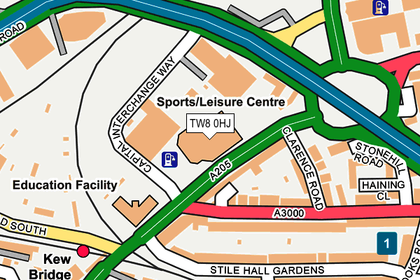
TW8 0HJ is located in the Chiswick Riverside electoral ward, within the London borough of Hounslow and the English Parliamentary constituency of Brentford and Isleworth. The Sub Integrated Care Board (ICB) Location is NHS North West London ICB - W2U3Z and the police force is Metropolitan Police. This postcode has been in use since October 1987.


GetTheData
Source: OS OpenMap – Local (Ordnance Survey)
Source: OS VectorMap District (Ordnance Survey)
Licence: Open Government Licence (requires attribution)
| Easting | 519177 |
| Northing | 178285 |
| Latitude | 51.490961 |
| Longitude | -0.284792 |
GetTheData
Source: Open Postcode Geo
Licence: Open Government Licence
| Country | England |
| Postcode District | TW8 |
➜ See where TW8 is on a map ➜ Where is Brentford? | |
GetTheData
Source: Land Registry Price Paid Data
Licence: Open Government Licence
Elevation or altitude of TW8 0HJ as distance above sea level:
| Metres | Feet | |
|---|---|---|
| Elevation | 10m | 33ft |
Elevation is measured from the approximate centre of the postcode, to the nearest point on an OS contour line from OS Terrain 50, which has contour spacing of ten vertical metres.
➜ How high above sea level am I? Find the elevation of your current position using your device's GPS.
GetTheData
Source: Open Postcode Elevation
Licence: Open Government Licence
| Ward | Chiswick Riverside |
| Constituency | Brentford And Isleworth |
GetTheData
Source: ONS Postcode Database
Licence: Open Government Licence
| Brentford Fountain Leisure Centre (Chiswick High Road) | Gunnersbury | 36m |
| Brentford Fountain Leisure Centre (Chiswick High Road) | Gunnersbury | 56m |
| Chiswick Roundabout Gunnersbry | Gunnersbury | 131m |
| Chiswick Roundabout Gunnersbry (Great West Road) | Gunnersbury | 185m |
| Kew Bridge National Rail Stn (Kew Bridge Road) | Gunnersbury | 239m |
| Gunnersbury Underground Station | Gunnersbury | 668m |
| Chiswick Park Underground Station | Chiswick Park | 1,237m |
| Acton Town Underground Station | Acton Town | 1,379m |
| Kew Bridge Station | 0.2km |
| Gunnersbury Station | 0.7km |
| South Acton Station | 1.4km |
GetTheData
Source: NaPTAN
Licence: Open Government Licence
GetTheData
Source: ONS Postcode Database
Licence: Open Government Licence


➜ Get more ratings from the Food Standards Agency
GetTheData
Source: Food Standards Agency
Licence: FSA terms & conditions
| Last Collection | |||
|---|---|---|---|
| Location | Mon-Fri | Sat | Distance |
| Post Office | 17:30 | 12:00 | 57m |
| Kew Bridge Station | 18:30 | 11:15 | 256m |
| Chiswick High Road | 17:30 | 12:00 | 339m |
GetTheData
Source: Dracos
Licence: Creative Commons Attribution-ShareAlike
The below table lists the International Territorial Level (ITL) codes (formerly Nomenclature of Territorial Units for Statistics (NUTS) codes) and Local Administrative Units (LAU) codes for TW8 0HJ:
| ITL 1 Code | Name |
|---|---|
| TLI | London |
| ITL 2 Code | Name |
| TLI7 | Outer London - West and North West |
| ITL 3 Code | Name |
| TLI75 | Hounslow and Richmond upon Thames |
| LAU 1 Code | Name |
| E09000018 | Hounslow |
GetTheData
Source: ONS Postcode Directory
Licence: Open Government Licence
The below table lists the Census Output Area (OA), Lower Layer Super Output Area (LSOA), and Middle Layer Super Output Area (MSOA) for TW8 0HJ:
| Code | Name | |
|---|---|---|
| OA | E00012758 | |
| LSOA | E01002566 | Hounslow 003C |
| MSOA | E02000528 | Hounslow 003 |
GetTheData
Source: ONS Postcode Directory
Licence: Open Government Licence
| W4 3AY | Chiswick High Road | 67m |
| W4 3AU | London Stile | 69m |
| W4 5BB | Bridgman Road | 70m |
| W4 3AT | Wellesley Road | 114m |
| W4 3AP | Wellesley Road | 122m |
| W4 5QJ | Great West Road | 124m |
| W4 3AG | Stile Hall Parade | 142m |
| W4 3AS | Clarence Road | 163m |
| W4 3BS | Stile Hall Gardens | 168m |
| W4 3AA | Surrey Crescent | 175m |
GetTheData
Source: Open Postcode Geo; Land Registry Price Paid Data
Licence: Open Government Licence