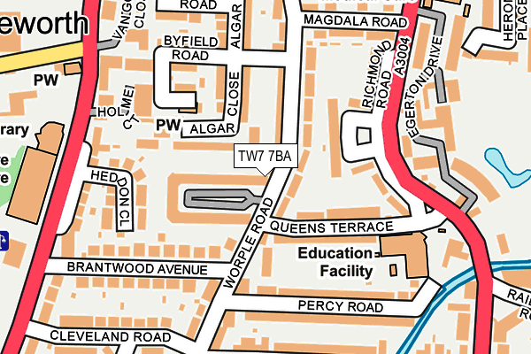
TW7 7BA lies on Worple Road in Isleworth. TW7 7BA is located in the Isleworth electoral ward, within the London borough of Hounslow and the English Parliamentary constituency of Brentford and Isleworth. The Sub Integrated Care Board (ICB) Location is NHS North West London ICB - W2U3Z and the police force is Metropolitan Police. This postcode has been in use since November 2002.


GetTheData
Source: OS OpenMap – Local (Ordnance Survey)
Source: OS VectorMap District (Ordnance Survey)
Licence: Open Government Licence (requires attribution)
| Easting | 516331 |
| Northing | 175480 |
| Latitude | 51.466343 |
| Longitude | -0.326689 |
GetTheData
Source: Open Postcode Geo
Licence: Open Government Licence
| Street | Worple Road |
| Town/City | Isleworth |
| Country | England |
| Postcode District | TW7 |
➜ See where TW7 is on a map ➜ Where is Isleworth? | |
GetTheData
Source: Land Registry Price Paid Data
Licence: Open Government Licence
Elevation or altitude of TW7 7BA as distance above sea level:
| Metres | Feet | |
|---|---|---|
| Elevation | 10m | 33ft |
Elevation is measured from the approximate centre of the postcode, to the nearest point on an OS contour line from OS Terrain 50, which has contour spacing of ten vertical metres.
➜ How high above sea level am I? Find the elevation of your current position using your device's GPS.
GetTheData
Source: Open Postcode Elevation
Licence: Open Government Licence
| Ward | Isleworth |
| Constituency | Brentford And Isleworth |
GetTheData
Source: ONS Postcode Database
Licence: Open Government Licence
55, WORPLE ROAD, ISLEWORTH, TW7 7BA 2005 14 OCT £250,000 |
57, WORPLE ROAD, ISLEWORTH, TW7 7BA 2002 31 MAY £395,000 |
55, WORPLE ROAD, ISLEWORTH, TW7 7BA 2002 31 MAY £200,000 |
GetTheData
Source: HM Land Registry Price Paid Data
Licence: Contains HM Land Registry data © Crown copyright and database right 2025. This data is licensed under the Open Government Licence v3.0.
| Richmond Road Queens Terrace | Isleworth | 177m |
| Richmond Road Queens Terrace | Isleworth | 184m |
| Isleworth Library (Twickenham Road) | Isleworth | 212m |
| Isleworth Leisure Centre And Library (Twickenham Road) | Isleworth | 236m |
| South Street (Tw7) (South Street) | Isleworth | 247m |
| Isleworth Station | 1.2km |
| St Margarets (London) Station | 1.3km |
| Syon Lane Station | 1.7km |
GetTheData
Source: NaPTAN
Licence: Open Government Licence
| Percentage of properties with Next Generation Access | 100.0% |
| Percentage of properties with Superfast Broadband | 100.0% |
| Percentage of properties with Ultrafast Broadband | 100.0% |
| Percentage of properties with Full Fibre Broadband | 0.0% |
Superfast Broadband is between 30Mbps and 300Mbps
Ultrafast Broadband is > 300Mbps
| Percentage of properties unable to receive 2Mbps | 0.0% |
| Percentage of properties unable to receive 5Mbps | 0.0% |
| Percentage of properties unable to receive 10Mbps | 0.0% |
| Percentage of properties unable to receive 30Mbps | 0.0% |
GetTheData
Source: Ofcom
Licence: Ofcom Terms of Use (requires attribution)
GetTheData
Source: ONS Postcode Database
Licence: Open Government Licence


➜ Get more ratings from the Food Standards Agency
GetTheData
Source: Food Standards Agency
Licence: FSA terms & conditions
| Last Collection | |||
|---|---|---|---|
| Location | Mon-Fri | Sat | Distance |
| Old Isleworth | 17:30 | 12:00 | 284m |
| Steele Road | 17:45 | 12:00 | 301m |
| 385 St Margaret's Road | 17:00 | 11:00 | 334m |
GetTheData
Source: Dracos
Licence: Creative Commons Attribution-ShareAlike
The below table lists the International Territorial Level (ITL) codes (formerly Nomenclature of Territorial Units for Statistics (NUTS) codes) and Local Administrative Units (LAU) codes for TW7 7BA:
| ITL 1 Code | Name |
|---|---|
| TLI | London |
| ITL 2 Code | Name |
| TLI7 | Outer London - West and North West |
| ITL 3 Code | Name |
| TLI75 | Hounslow and Richmond upon Thames |
| LAU 1 Code | Name |
| E09000018 | Hounslow |
GetTheData
Source: ONS Postcode Directory
Licence: Open Government Licence
The below table lists the Census Output Area (OA), Lower Layer Super Output Area (LSOA), and Middle Layer Super Output Area (MSOA) for TW7 7BA:
| Code | Name | |
|---|---|---|
| OA | E00013277 | |
| LSOA | E01002670 | Hounslow 020B |
| MSOA | E02000545 | Hounslow 020 |
GetTheData
Source: ONS Postcode Directory
Licence: Open Government Licence
| TW7 7AW | Kings Terrace | 64m |
| TW7 7AQ | Algar Close | 69m |
| TW7 7AT | Worple Road | 71m |
| TW7 7BD | Elizabeth Gardens | 79m |
| TW7 7BS | Richmond Road | 89m |
| TW7 7AG | Algar Road | 99m |
| TW7 7DB | Queens Terrace | 102m |
| TW7 7AP | Worple Road | 120m |
| TW7 7BB | Carrick Close | 133m |
| TW7 7AF | Byfield Road | 154m |
GetTheData
Source: Open Postcode Geo; Land Registry Price Paid Data
Licence: Open Government Licence