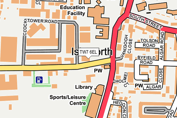
TW7 6EL lies on Worton Road in Isleworth. TW7 6EL is located in the Isleworth electoral ward, within the London borough of Hounslow and the English Parliamentary constituency of Brentford and Isleworth. The Sub Integrated Care Board (ICB) Location is NHS North West London ICB - W2U3Z and the police force is Metropolitan Police. This postcode has been in use since January 1980.


GetTheData
Source: OS OpenMap – Local (Ordnance Survey)
Source: OS VectorMap District (Ordnance Survey)
Licence: Open Government Licence (requires attribution)
| Easting | 516050 |
| Northing | 175629 |
| Latitude | 51.467739 |
| Longitude | -0.330661 |
GetTheData
Source: Open Postcode Geo
Licence: Open Government Licence
| Street | Worton Road |
| Town/City | Isleworth |
| Country | England |
| Postcode District | TW7 |
➜ See where TW7 is on a map ➜ Where is Isleworth? | |
GetTheData
Source: Land Registry Price Paid Data
Licence: Open Government Licence
Elevation or altitude of TW7 6EL as distance above sea level:
| Metres | Feet | |
|---|---|---|
| Elevation | 10m | 33ft |
Elevation is measured from the approximate centre of the postcode, to the nearest point on an OS contour line from OS Terrain 50, which has contour spacing of ten vertical metres.
➜ How high above sea level am I? Find the elevation of your current position using your device's GPS.
GetTheData
Source: Open Postcode Elevation
Licence: Open Government Licence
| Ward | Isleworth |
| Constituency | Brentford And Isleworth |
GetTheData
Source: ONS Postcode Database
Licence: Open Government Licence
| Worton Road (Twickenham Road) | Isleworth | 74m |
| Isleworth Library (Twickenham Road) | Isleworth | 117m |
| Clock Tower Industrial Estate | Isleworth | 159m |
| Isleworth Leisure Centre And Library (Twickenham Road) | Isleworth | 163m |
| Clock Tower Industrial Estate | Isleworth | 257m |
| Isleworth Station | 0.9km |
| St Margarets (London) Station | 1.6km |
| Syon Lane Station | 1.6km |
GetTheData
Source: NaPTAN
Licence: Open Government Licence
GetTheData
Source: ONS Postcode Database
Licence: Open Government Licence

➜ Get more ratings from the Food Standards Agency
GetTheData
Source: Food Standards Agency
Licence: FSA terms & conditions
| Last Collection | |||
|---|---|---|---|
| Location | Mon-Fri | Sat | Distance |
| Worton Road | 17:45 | 11:45 | 77m |
| The Maltings, St John's Road | 17:30 | 11:45 | 346m |
| Twickenham Road / St John's Road | 17:30 | 11:45 | 359m |
GetTheData
Source: Dracos
Licence: Creative Commons Attribution-ShareAlike
The below table lists the International Territorial Level (ITL) codes (formerly Nomenclature of Territorial Units for Statistics (NUTS) codes) and Local Administrative Units (LAU) codes for TW7 6EL:
| ITL 1 Code | Name |
|---|---|
| TLI | London |
| ITL 2 Code | Name |
| TLI7 | Outer London - West and North West |
| ITL 3 Code | Name |
| TLI75 | Hounslow and Richmond upon Thames |
| LAU 1 Code | Name |
| E09000018 | Hounslow |
GetTheData
Source: ONS Postcode Directory
Licence: Open Government Licence
The below table lists the Census Output Area (OA), Lower Layer Super Output Area (LSOA), and Middle Layer Super Output Area (MSOA) for TW7 6EL:
| Code | Name | |
|---|---|---|
| OA | E00013267 | |
| LSOA | E01002668 | Hounslow 014A |
| MSOA | E02000539 | Hounslow 014 |
GetTheData
Source: ONS Postcode Directory
Licence: Open Government Licence
| TW7 6DW | Worton Road | 87m |
| TW7 7DJ | Twickenham Road | 134m |
| TW7 6EE | Worton Road | 135m |
| TW7 7DL | Twickenham Road | 141m |
| TW7 7AF | Byfield Road | 193m |
| TW7 7AE | Tolson Road | 194m |
| TW7 7BB | Carrick Close | 200m |
| TW7 7DP | Heddon Close | 202m |
| TW7 6DS | Worton Road | 215m |
| TW7 6ST | Clydesdale Close | 216m |
GetTheData
Source: Open Postcode Geo; Land Registry Price Paid Data
Licence: Open Government Licence