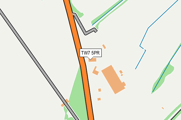
TW7 5PR lies on Windmill Lane in Isleworth. TW7 5PR is located in the Osterley & Spring Grove electoral ward, within the London borough of Hounslow and the English Parliamentary constituency of Brentford and Isleworth. The Sub Integrated Care Board (ICB) Location is NHS North West London ICB - W2U3Z and the police force is Metropolitan Police. This postcode has been in use since January 1980.


GetTheData
Source: OS OpenMap – Local (Ordnance Survey)
Source: OS VectorMap District (Ordnance Survey)
Licence: Open Government Licence (requires attribution)
| Easting | 515469 |
| Northing | 178220 |
| Latitude | 51.491146 |
| Longitude | -0.338176 |
GetTheData
Source: Open Postcode Geo
Licence: Open Government Licence
| Street | Windmill Lane |
| Town/City | Isleworth |
| Country | England |
| Postcode District | TW7 |
➜ See where TW7 is on a map ➜ Where is London? | |
GetTheData
Source: Land Registry Price Paid Data
Licence: Open Government Licence
Elevation or altitude of TW7 5PR as distance above sea level:
| Metres | Feet | |
|---|---|---|
| Elevation | 20m | 66ft |
Elevation is measured from the approximate centre of the postcode, to the nearest point on an OS contour line from OS Terrain 50, which has contour spacing of ten vertical metres.
➜ How high above sea level am I? Find the elevation of your current position using your device's GPS.
GetTheData
Source: Open Postcode Elevation
Licence: Open Government Licence
| Ward | Osterley & Spring Grove |
| Constituency | Brentford And Isleworth |
GetTheData
Source: ONS Postcode Database
Licence: Open Government Licence
| Jersey Road | Osterley | 476m |
| Jersey Road | Osterley | 496m |
| Wood Lane Railway Bridge | Osterley | 542m |
| Conquest Club | Osterley | 658m |
| Conquest Club | Osterley | 671m |
| Boston Manor Underground Station | Boston Manor | 1,047m |
| Osterley Underground Station | Osterley | 1,468m |
| Syon Lane Station | 1.4km |
| Isleworth Station | 1.8km |
| Brentford Station | 2km |
GetTheData
Source: NaPTAN
Licence: Open Government Licence
| Percentage of properties with Next Generation Access | 100.0% |
| Percentage of properties with Superfast Broadband | 0.0% |
| Percentage of properties with Ultrafast Broadband | 0.0% |
| Percentage of properties with Full Fibre Broadband | 0.0% |
Superfast Broadband is between 30Mbps and 300Mbps
Ultrafast Broadband is > 300Mbps
| Percentage of properties unable to receive 2Mbps | 0.0% |
| Percentage of properties unable to receive 5Mbps | 0.0% |
| Percentage of properties unable to receive 10Mbps | 0.0% |
| Percentage of properties unable to receive 30Mbps | 100.0% |
GetTheData
Source: Ofcom
Licence: Ofcom Terms of Use (requires attribution)
GetTheData
Source: ONS Postcode Database
Licence: Open Government Licence


➜ Get more ratings from the Food Standards Agency
GetTheData
Source: Food Standards Agency
Licence: FSA terms & conditions
| Last Collection | |||
|---|---|---|---|
| Location | Mon-Fri | Sat | Distance |
| Gower Road | 18:30 | 11:30 | 613m |
| Tesco Stores, Grant Way | 17:15 | 11:30 | 819m |
| Wood Lane / Great West Road | 18:30 | 11:30 | 932m |
GetTheData
Source: Dracos
Licence: Creative Commons Attribution-ShareAlike
The below table lists the International Territorial Level (ITL) codes (formerly Nomenclature of Territorial Units for Statistics (NUTS) codes) and Local Administrative Units (LAU) codes for TW7 5PR:
| ITL 1 Code | Name |
|---|---|
| TLI | London |
| ITL 2 Code | Name |
| TLI7 | Outer London - West and North West |
| ITL 3 Code | Name |
| TLI75 | Hounslow and Richmond upon Thames |
| LAU 1 Code | Name |
| E09000018 | Hounslow |
GetTheData
Source: ONS Postcode Directory
Licence: Open Government Licence
The below table lists the Census Output Area (OA), Lower Layer Super Output Area (LSOA), and Middle Layer Super Output Area (MSOA) for TW7 5PR:
| Code | Name | |
|---|---|---|
| OA | E00013303 | |
| LSOA | E01002678 | Hounslow 009B |
| MSOA | E02000534 | Hounslow 009 |
GetTheData
Source: ONS Postcode Directory
Licence: Open Government Licence
| TW7 5PL | Jersey Road | 475m |
| TW7 5PJ | Jersey Road | 489m |
| TW7 5PX | Oaklands Avenue | 521m |
| TW7 5PU | Syon Lane | 531m |
| TW7 5PF | Crowntree Close | 637m |
| TW7 5EH | Wood Lane | 641m |
| TW7 5PY | Oaklands Avenue | 649m |
| TW7 5QA | Ashley Drive | 653m |
| TW7 5PZ | Syon Lane | 670m |
| TW7 5PQ | Stags Way | 672m |
GetTheData
Source: Open Postcode Geo; Land Registry Price Paid Data
Licence: Open Government Licence