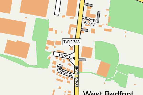
TW19 7AS lies on Long Lane in Staines. TW19 7AS is located in the Stanwell North electoral ward, within the local authority district of Spelthorne and the English Parliamentary constituency of Spelthorne. The Sub Integrated Care Board (ICB) Location is NHS Surrey Heartlands ICB - 92A and the police force is Surrey. This postcode has been in use since January 1980.


GetTheData
Source: OS OpenMap – Local (Ordnance Survey)
Source: OS VectorMap District (Ordnance Survey)
Licence: Open Government Licence (requires attribution)
| Easting | 506788 |
| Northing | 174024 |
| Latitude | 51.455135 |
| Longitude | -0.464454 |
GetTheData
Source: Open Postcode Geo
Licence: Open Government Licence
| Street | Long Lane |
| Town/City | Staines |
| Country | England |
| Postcode District | TW19 |
➜ See where TW19 is on a map ➜ Where is West Bedfont? | |
GetTheData
Source: Land Registry Price Paid Data
Licence: Open Government Licence
Elevation or altitude of TW19 7AS as distance above sea level:
| Metres | Feet | |
|---|---|---|
| Elevation | 20m | 66ft |
Elevation is measured from the approximate centre of the postcode, to the nearest point on an OS contour line from OS Terrain 50, which has contour spacing of ten vertical metres.
➜ How high above sea level am I? Find the elevation of your current position using your device's GPS.
GetTheData
Source: Open Postcode Elevation
Licence: Open Government Licence
| Ward | Stanwell North |
| Constituency | Spelthorne |
GetTheData
Source: ONS Postcode Database
Licence: Open Government Licence
| Long Lane (Bedfont Road) | West Bedfont | 243m |
| Long Lane (Bedfont Road) | West Bedfont | 264m |
| Sealand Road (Southern Perimeter Road) | Heathrow Airport | 336m |
| Heathrow Cargo Area (Stirling Road) | Heathrow Airport | 476m |
| Cargo Centre (Sealand Road) | Heathrow Airport | 478m |
| Heathrow Terminal 4 Underground Station | Heathrow Airport Terminal 4 | 1,352m |
| Heathrow Terminal 4 (Rail-Air) | 1.3km |
| Heathrow Terminal 4 Station | 1.4km |
| Heathrow Airport Central Bus Stn (Rail-Air) | 1.9km |
GetTheData
Source: NaPTAN
Licence: Open Government Licence
| Percentage of properties with Next Generation Access | 100.0% |
| Percentage of properties with Superfast Broadband | 100.0% |
| Percentage of properties with Ultrafast Broadband | 100.0% |
| Percentage of properties with Full Fibre Broadband | 0.0% |
Superfast Broadband is between 30Mbps and 300Mbps
Ultrafast Broadband is > 300Mbps
| Median download speed | 80.0Mbps |
| Average download speed | 96.5Mbps |
| Maximum download speed | 200.00Mbps |
| Median upload speed | 20.0Mbps |
| Average upload speed | 19.8Mbps |
| Maximum upload speed | 20.00Mbps |
| Percentage of properties unable to receive 2Mbps | 0.0% |
| Percentage of properties unable to receive 5Mbps | 0.0% |
| Percentage of properties unable to receive 10Mbps | 0.0% |
| Percentage of properties unable to receive 30Mbps | 0.0% |
GetTheData
Source: Ofcom
Licence: Ofcom Terms of Use (requires attribution)
Estimated total energy consumption in TW19 7AS by fuel type, 2015.
| Consumption (kWh) | 60,240 |
|---|---|
| Meter count | 6 |
| Mean (kWh/meter) | 10,040 |
| Median (kWh/meter) | 9,123 |
| Consumption (kWh) | 32,857 |
|---|---|
| Meter count | 6 |
| Mean (kWh/meter) | 5,476 |
| Median (kWh/meter) | 3,729 |
GetTheData
Source: Postcode level gas estimates: 2015 (experimental)
Source: Postcode level electricity estimates: 2015 (experimental)
Licence: Open Government Licence
GetTheData
Source: ONS Postcode Database
Licence: Open Government Licence

➜ Get more ratings from the Food Standards Agency
GetTheData
Source: Food Standards Agency
Licence: FSA terms & conditions
| Last Collection | |||
|---|---|---|---|
| Location | Mon-Fri | Sat | Distance |
| Northumberland Close | 18:30 | 583m | |
| Kingsway | 17:30 | 11:30 | 1,236m |
| The Green Man, Green Man Lane | 18:30 | 11:45 | 1,774m |
GetTheData
Source: Dracos
Licence: Creative Commons Attribution-ShareAlike
The below table lists the International Territorial Level (ITL) codes (formerly Nomenclature of Territorial Units for Statistics (NUTS) codes) and Local Administrative Units (LAU) codes for TW19 7AS:
| ITL 1 Code | Name |
|---|---|
| TLJ | South East (England) |
| ITL 2 Code | Name |
| TLJ2 | Surrey, East and West Sussex |
| ITL 3 Code | Name |
| TLJ25 | West Surrey |
| LAU 1 Code | Name |
| E07000213 | Spelthorne |
GetTheData
Source: ONS Postcode Directory
Licence: Open Government Licence
The below table lists the Census Output Area (OA), Lower Layer Super Output Area (LSOA), and Middle Layer Super Output Area (MSOA) for TW19 7AS:
| Code | Name | |
|---|---|---|
| OA | E00156788 | |
| LSOA | E01030746 | Spelthorne 002D |
| MSOA | E02006404 | Spelthorne 002 |
GetTheData
Source: ONS Postcode Directory
Licence: Open Government Licence
| TW19 7AW | Brook Close | 91m |
| TW19 7AU | Long Lane | 112m |
| TW19 7AN | Long Lane | 146m |
| TW19 7BG | Dudley Place | 153m |
| TW19 7LN | Northumberland Close | 281m |
| TW19 7AL | Long Lane | 381m |
| TW19 7BQ | Short Lane | 410m |
| TW19 7BH | Short Lane | 435m |
| TW19 7LX | Cleveland Park | 438m |
| TW19 7EP | Cordelia Gardens | 469m |
GetTheData
Source: Open Postcode Geo; Land Registry Price Paid Data
Licence: Open Government Licence