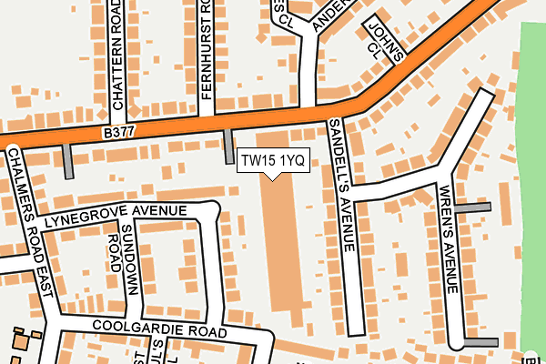
TW15 1YQ is located in the Ashford East electoral ward, within the local authority district of Spelthorne and the English Parliamentary constituency of Spelthorne. The Sub Integrated Care Board (ICB) Location is NHS Surrey Heartlands ICB - 92A and the police force is Surrey. This postcode has been in use since May 1994.


GetTheData
Source: OS OpenMap – Local (Ordnance Survey)
Source: OS VectorMap District (Ordnance Survey)
Licence: Open Government Licence (requires attribution)
| Easting | 508273 |
| Northing | 171515 |
| Latitude | 51.432302 |
| Longitude | -0.443835 |
GetTheData
Source: Open Postcode Geo
Licence: Open Government Licence
| Country | England |
| Postcode District | TW15 |
➜ See where TW15 is on a map ➜ Where is Ashford? | |
GetTheData
Source: Land Registry Price Paid Data
Licence: Open Government Licence
Elevation or altitude of TW15 1YQ as distance above sea level:
| Metres | Feet | |
|---|---|---|
| Elevation | 20m | 66ft |
Elevation is measured from the approximate centre of the postcode, to the nearest point on an OS contour line from OS Terrain 50, which has contour spacing of ten vertical metres.
➜ How high above sea level am I? Find the elevation of your current position using your device's GPS.
GetTheData
Source: Open Postcode Elevation
Licence: Open Government Licence
| Ward | Ashford East |
| Constituency | Spelthorne |
GetTheData
Source: ONS Postcode Database
Licence: Open Government Licence
| Anderson Drive (Feltham Road) | Chattern Hill | 73m |
| Anderson Drive (Feltham Road) | Chattern Hill | 77m |
| Charles Court (Feltham Road) | Chattern Hill | 222m |
| Charles Court (Feltham Road) | Chattern Hill | 243m |
| Challenge Road (Feltham Road) | Chattern Hill | 294m |
| Ashford (Surrey) Station | 1.7km |
| Upper Halliford Station | 2.3km |
| Sunbury Station | 2.4km |
GetTheData
Source: NaPTAN
Licence: Open Government Licence
| Median download speed | 11.4Mbps |
| Average download speed | 9.1Mbps |
| Maximum download speed | 13.68Mbps |
| Median upload speed | 1.0Mbps |
| Average upload speed | 1.0Mbps |
| Maximum upload speed | 1.57Mbps |
GetTheData
Source: Ofcom
Licence: Ofcom Terms of Use (requires attribution)
GetTheData
Source: ONS Postcode Database
Licence: Open Government Licence

➜ Get more ratings from the Food Standards Agency
GetTheData
Source: Food Standards Agency
Licence: FSA terms & conditions
| Last Collection | |||
|---|---|---|---|
| Location | Mon-Fri | Sat | Distance |
| Feltham Road | 18:30 | 11:30 | 127m |
| The Clumps | 18:30 | 11:30 | 383m |
| Challenge Road | 393m | ||
GetTheData
Source: Dracos
Licence: Creative Commons Attribution-ShareAlike
The below table lists the International Territorial Level (ITL) codes (formerly Nomenclature of Territorial Units for Statistics (NUTS) codes) and Local Administrative Units (LAU) codes for TW15 1YQ:
| ITL 1 Code | Name |
|---|---|
| TLJ | South East (England) |
| ITL 2 Code | Name |
| TLJ2 | Surrey, East and West Sussex |
| ITL 3 Code | Name |
| TLJ25 | West Surrey |
| LAU 1 Code | Name |
| E07000213 | Spelthorne |
GetTheData
Source: ONS Postcode Directory
Licence: Open Government Licence
The below table lists the Census Output Area (OA), Lower Layer Super Output Area (LSOA), and Middle Layer Super Output Area (MSOA) for TW15 1YQ:
| Code | Name | |
|---|---|---|
| OA | E00156577 | |
| LSOA | E01030706 | Spelthorne 005F |
| MSOA | E02006407 | Spelthorne 005 |
GetTheData
Source: ONS Postcode Directory
Licence: Open Government Licence
| TW15 1AJ | Sandells Avenue | 98m |
| TW15 1AG | Feltham Road | 110m |
| TW15 1ER | Lynegrove Avenue | 113m |
| TW15 1BH | Anderson Drive | 130m |
| TW15 1AL | Sandells Avenue | 130m |
| TW15 1EP | Lynegrove Avenue | 138m |
| TW15 1EL | Coolgardie Road | 147m |
| TW15 1AD | Feltham Road | 151m |
| TW15 1EW | Sundown Road | 167m |
| TW15 1AW | Wrens Avenue | 197m |
GetTheData
Source: Open Postcode Geo; Land Registry Price Paid Data
Licence: Open Government Licence