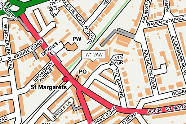
TW1 2AW is located in the St Margarets & North Twickenham electoral ward, within the London borough of Richmond upon Thames and the English Parliamentary constituency of Twickenham. The Sub Integrated Care Board (ICB) Location is NHS South West London ICB - 36L and the police force is Metropolitan Police. This postcode has been in use since January 1980.


GetTheData
Source: OS OpenMap – Local (Ordnance Survey)
Source: OS VectorMap District (Ordnance Survey)
Licence: Open Government Licence (requires attribution)
| Easting | 516902 |
| Northing | 174310 |
| Latitude | 51.455710 |
| Longitude | -0.318859 |
GetTheData
Source: Open Postcode Geo
Licence: Open Government Licence
| Country | England |
| Postcode District | TW1 |
➜ See where TW1 is on a map ➜ Where is London? | |
GetTheData
Source: Land Registry Price Paid Data
Licence: Open Government Licence
Elevation or altitude of TW1 2AW as distance above sea level:
| Metres | Feet | |
|---|---|---|
| Elevation | 10m | 33ft |
Elevation is measured from the approximate centre of the postcode, to the nearest point on an OS contour line from OS Terrain 50, which has contour spacing of ten vertical metres.
➜ How high above sea level am I? Find the elevation of your current position using your device's GPS.
GetTheData
Source: Open Postcode Elevation
Licence: Open Government Licence
| Ward | St Margarets & North Twickenham |
| Constituency | Twickenham |
GetTheData
Source: ONS Postcode Database
Licence: Open Government Licence
| St Margarets (St Margaret's Road) | St Margarets | 61m |
| St Margarets (St Margaret's Road) | St Margarets | 121m |
| Sandycoombe Road (St Margarets Road) | St Margarets | 238m |
| Sandycoombe Road (St Margarets Road) | St Margarets | 249m |
| Chertsey Road (St Margarets Road) | St Margarets | 369m |
| Richmond Underground Station | Richmond | 1,478m |
| St Margarets (London) Station | 0.1km |
| Twickenham Station | 1km |
| Richmond (London) Station | 1.5km |
GetTheData
Source: NaPTAN
Licence: Open Government Licence
GetTheData
Source: ONS Postcode Database
Licence: Open Government Licence


➜ Get more ratings from the Food Standards Agency
GetTheData
Source: Food Standards Agency
Licence: FSA terms & conditions
| Last Collection | |||
|---|---|---|---|
| Location | Mon-Fri | Sat | Distance |
| P.o. 118 St Margaret's Road | 18:30 | 12:15 | 84m |
| Cassillis Road | 17:30 | 12:00 | 217m |
| Baronsfield Road | 17:30 | 11:30 | 218m |
GetTheData
Source: Dracos
Licence: Creative Commons Attribution-ShareAlike
The below table lists the International Territorial Level (ITL) codes (formerly Nomenclature of Territorial Units for Statistics (NUTS) codes) and Local Administrative Units (LAU) codes for TW1 2AW:
| ITL 1 Code | Name |
|---|---|
| TLI | London |
| ITL 2 Code | Name |
| TLI7 | Outer London - West and North West |
| ITL 3 Code | Name |
| TLI75 | Hounslow and Richmond upon Thames |
| LAU 1 Code | Name |
| E09000027 | Richmond upon Thames |
GetTheData
Source: ONS Postcode Directory
Licence: Open Government Licence
The below table lists the Census Output Area (OA), Lower Layer Super Output Area (LSOA), and Middle Layer Super Output Area (MSOA) for TW1 2AW:
| Code | Name | |
|---|---|---|
| OA | E00019453 | |
| LSOA | E01003872 | Richmond upon Thames 007D |
| MSOA | E02000790 | Richmond upon Thames 007 |
GetTheData
Source: ONS Postcode Directory
Licence: Open Government Licence
| TW1 2AL | The Barons | 66m |
| TW1 1RQ | Old Lodge Place | 67m |
| TW1 2AA | St Margarets Road | 74m |
| TW1 2AJ | Kelvin Drive | 87m |
| TW1 1RP | Nicol Close | 90m |
| TW1 2AH | Kelvin Drive | 93m |
| TW1 2AN | The Barons | 99m |
| TW1 2LH | St Margarets Road | 108m |
| TW1 1RG | St Margarets Road | 147m |
| TW1 1RU | Cassilis Road | 148m |
GetTheData
Source: Open Postcode Geo; Land Registry Price Paid Data
Licence: Open Government Licence