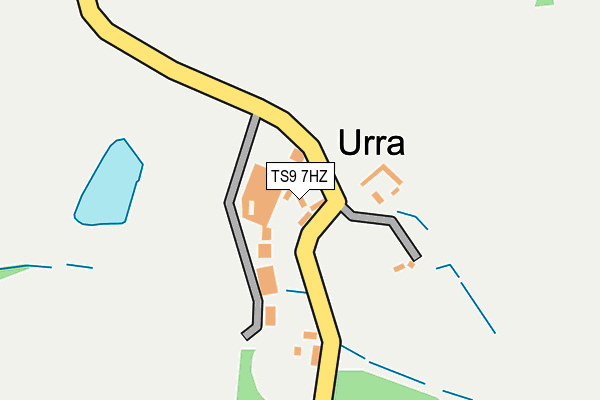
TS9 7HZ is in Chop Gate, Middlesbrough. TS9 7HZ is located in the Great Ayton electoral ward, within the unitary authority of North Yorkshire and the English Parliamentary constituency of Richmond (Yorks). The Sub Integrated Care Board (ICB) Location is NHS Humber and North Yorkshire ICB - 42D and the police force is North Yorkshire. This postcode has been in use since January 1980.


GetTheData
Source: OS OpenMap – Local (Ordnance Survey)
Source: OS VectorMap District (Ordnance Survey)
Licence: Open Government Licence (requires attribution)
| Easting | 457078 |
| Northing | 501976 |
| Latitude | 54.410045 |
| Longitude | -1.122096 |
GetTheData
Source: Open Postcode Geo
Licence: Open Government Licence
| Locality | Chop Gate |
| Town/City | Middlesbrough |
| Country | England |
| Postcode District | TS9 |
➜ See where TS9 is on a map ➜ Where is Urra? | |
GetTheData
Source: Land Registry Price Paid Data
Licence: Open Government Licence
Elevation or altitude of TS9 7HZ as distance above sea level:
| Metres | Feet | |
|---|---|---|
| Elevation | 250m | 820ft |
Elevation is measured from the approximate centre of the postcode, to the nearest point on an OS contour line from OS Terrain 50, which has contour spacing of ten vertical metres.
➜ How high above sea level am I? Find the elevation of your current position using your device's GPS.
GetTheData
Source: Open Postcode Elevation
Licence: Open Government Licence
| Ward | Great Ayton |
| Constituency | Richmond (Yorks) |
GetTheData
Source: ONS Postcode Database
Licence: Open Government Licence
| Percentage of properties with Next Generation Access | 0.0% |
| Percentage of properties with Superfast Broadband | 0.0% |
| Percentage of properties with Ultrafast Broadband | 0.0% |
| Percentage of properties with Full Fibre Broadband | 0.0% |
Superfast Broadband is between 30Mbps and 300Mbps
Ultrafast Broadband is > 300Mbps
| Percentage of properties unable to receive 2Mbps | 0.0% |
| Percentage of properties unable to receive 5Mbps | 87.5% |
| Percentage of properties unable to receive 10Mbps | 100.0% |
| Percentage of properties unable to receive 30Mbps | 100.0% |
GetTheData
Source: Ofcom
Licence: Ofcom Terms of Use (requires attribution)
Estimated total energy consumption in TS9 7HZ by fuel type, 2015.
| Consumption (kWh) | 62,710 |
|---|---|
| Meter count | 9 |
| Mean (kWh/meter) | 6,968 |
| Median (kWh/meter) | 6,307 |
GetTheData
Source: Postcode level gas estimates: 2015 (experimental)
Source: Postcode level electricity estimates: 2015 (experimental)
Licence: Open Government Licence
GetTheData
Source: ONS Postcode Database
Licence: Open Government Licence
| Last Collection | |||
|---|---|---|---|
| Location | Mon-Fri | Sat | Distance |
| Urra Chopgate | 16:00 | 11:30 | 683m |
| Eller Bridge | 16:00 | 11:30 | 1,916m |
| Chopgate | 16:30 | 11:45 | 2,607m |
GetTheData
Source: Dracos
Licence: Creative Commons Attribution-ShareAlike
The below table lists the International Territorial Level (ITL) codes (formerly Nomenclature of Territorial Units for Statistics (NUTS) codes) and Local Administrative Units (LAU) codes for TS9 7HZ:
| ITL 1 Code | Name |
|---|---|
| TLE | Yorkshire and The Humber |
| ITL 2 Code | Name |
| TLE2 | North Yorkshire |
| ITL 3 Code | Name |
| TLE22 | North Yorkshire CC |
| LAU 1 Code | Name |
| E07000164 | Hambleton |
GetTheData
Source: ONS Postcode Directory
Licence: Open Government Licence
The below table lists the Census Output Area (OA), Lower Layer Super Output Area (LSOA), and Middle Layer Super Output Area (MSOA) for TS9 7HZ:
| Code | Name | |
|---|---|---|
| OA | E00140679 | |
| LSOA | E01027627 | Hambleton 002E |
| MSOA | E02005751 | Hambleton 002 |
GetTheData
Source: ONS Postcode Directory
Licence: Open Government Licence
| TS9 7JB | 901m | |
| TS9 7JA | 1322m | |
| TS9 7JX | 1700m | |
| TS9 7HY | 1864m | |
| TS9 6RQ | 2501m | |
| TS9 7JL | 2567m | |
| TS9 6RF | 2640m | |
| TS9 7EZ | 3023m | |
| TS9 7HP | 3044m | |
| TS9 7JN | 3114m |
GetTheData
Source: Open Postcode Geo; Land Registry Price Paid Data
Licence: Open Government Licence