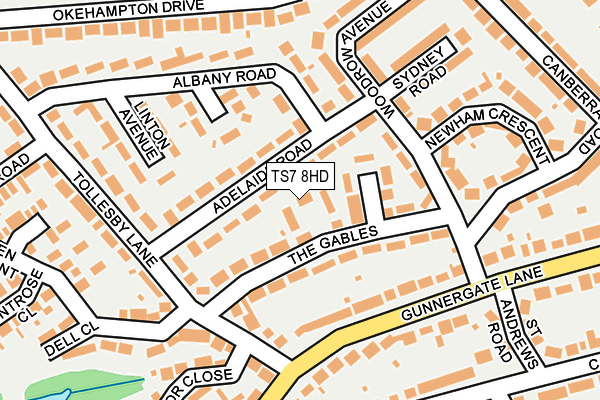
TS7 8HD lies on Aycliffe Road in Marton In Cleveland, Middlesbrough. TS7 8HD is located in the Marton West electoral ward, within the unitary authority of Middlesbrough and the English Parliamentary constituency of Middlesbrough South and East Cleveland. The Sub Integrated Care Board (ICB) Location is NHS North East and North Cumbria ICB - 16C and the police force is Cleveland. This postcode has been in use since January 1980.


GetTheData
Source: OS OpenMap – Local (Ordnance Survey)
Source: OS VectorMap District (Ordnance Survey)
Licence: Open Government Licence (requires attribution)
| Easting | 451495 |
| Northing | 515259 |
| Latitude | 54.530001 |
| Longitude | -1.205797 |
GetTheData
Source: Open Postcode Geo
Licence: Open Government Licence
| Street | Aycliffe Road |
| Locality | Marton In Cleveland |
| Town/City | Middlesbrough |
| Country | England |
| Postcode District | TS7 |
➜ See where TS7 is on a map ➜ Where is Middlesbrough? | |
GetTheData
Source: Land Registry Price Paid Data
Licence: Open Government Licence
Elevation or altitude of TS7 8HD as distance above sea level:
| Metres | Feet | |
|---|---|---|
| Elevation | 50m | 164ft |
Elevation is measured from the approximate centre of the postcode, to the nearest point on an OS contour line from OS Terrain 50, which has contour spacing of ten vertical metres.
➜ How high above sea level am I? Find the elevation of your current position using your device's GPS.
GetTheData
Source: Open Postcode Elevation
Licence: Open Government Licence
| Ward | Marton West |
| Constituency | Middlesbrough South And East Cleveland |
GetTheData
Source: ONS Postcode Database
Licence: Open Government Licence
| Tollesby Lane (Gunnergate Lane) | Coulby Newham | 253m |
| Tollesby Lane (Gunnergate Lane) | Coulby Newham | 260m |
| Shops (Gunnergate Lane) | Marton | 380m |
| Shops (Dixons Bank) | Marton | 448m |
| Country Club (Stokesley Road) | Marton | 516m |
| Marton Station | 1.7km |
| Gypsy Lane Station | 1.7km |
| Nunthorpe Station | 2.4km |
GetTheData
Source: NaPTAN
Licence: Open Government Licence
| Percentage of properties with Next Generation Access | 100.0% |
| Percentage of properties with Superfast Broadband | 100.0% |
| Percentage of properties with Ultrafast Broadband | 100.0% |
| Percentage of properties with Full Fibre Broadband | 0.0% |
Superfast Broadband is between 30Mbps and 300Mbps
Ultrafast Broadband is > 300Mbps
| Percentage of properties unable to receive 2Mbps | 0.0% |
| Percentage of properties unable to receive 5Mbps | 0.0% |
| Percentage of properties unable to receive 10Mbps | 0.0% |
| Percentage of properties unable to receive 30Mbps | 0.0% |
GetTheData
Source: Ofcom
Licence: Ofcom Terms of Use (requires attribution)
Estimated total energy consumption in TS7 8HD by fuel type, 2015.
| Consumption (kWh) | 103,755 |
|---|---|
| Meter count | 6 |
| Mean (kWh/meter) | 17,292 |
| Median (kWh/meter) | 17,603 |
| Consumption (kWh) | 13,747 |
|---|---|
| Meter count | 6 |
| Mean (kWh/meter) | 2,291 |
| Median (kWh/meter) | 2,276 |
GetTheData
Source: Postcode level gas estimates: 2015 (experimental)
Source: Postcode level electricity estimates: 2015 (experimental)
Licence: Open Government Licence
GetTheData
Source: ONS Postcode Database
Licence: Open Government Licence


➜ Get more ratings from the Food Standards Agency
GetTheData
Source: Food Standards Agency
Licence: FSA terms & conditions
| Last Collection | |||
|---|---|---|---|
| Location | Mon-Fri | Sat | Distance |
| Coulby Farm Way | 17:00 | 09:45 | 878m |
| Grey Towers | 16:45 | 09:00 | 1,922m |
| Ormesby Bank | 17:15 | 11:15 | 2,456m |
GetTheData
Source: Dracos
Licence: Creative Commons Attribution-ShareAlike
The below table lists the International Territorial Level (ITL) codes (formerly Nomenclature of Territorial Units for Statistics (NUTS) codes) and Local Administrative Units (LAU) codes for TS7 8HD:
| ITL 1 Code | Name |
|---|---|
| TLC | North East (England) |
| ITL 2 Code | Name |
| TLC1 | Tees Valley and Durham |
| ITL 3 Code | Name |
| TLC12 | South Teesside |
| LAU 1 Code | Name |
| E06000002 | Middlesbrough |
GetTheData
Source: ONS Postcode Directory
Licence: Open Government Licence
The below table lists the Census Output Area (OA), Lower Layer Super Output Area (LSOA), and Middle Layer Super Output Area (MSOA) for TS7 8HD:
| Code | Name | |
|---|---|---|
| OA | E00060859 | |
| LSOA | E01012067 | Middlesbrough 017C |
| MSOA | E02002512 | Middlesbrough 017 |
GetTheData
Source: ONS Postcode Directory
Licence: Open Government Licence
| TS7 8HF | Adelaide Road | 24m |
| TS7 8HE | Adelaide Road | 68m |
| TS7 8HA | The Gables | 69m |
| TS7 8HB | Brookdale Road | 90m |
| TS7 8EZ | Woodrow Avenue | 118m |
| TS7 8JP | Lowood Avenue | 121m |
| TS7 8JW | Albany Road | 121m |
| TS7 8JB | Gunnergate Lane | 126m |
| TS7 8JE | Tollesby Lane | 164m |
| TS7 8JA | Gunnergate Lane | 174m |
GetTheData
Source: Open Postcode Geo; Land Registry Price Paid Data
Licence: Open Government Licence