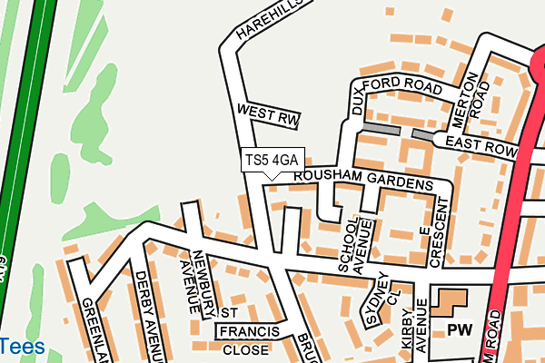
TS5 4GA lies on Hylton Road in Middlesbrough. TS5 4GA is located in the Ayresome electoral ward, within the unitary authority of Middlesbrough and the English Parliamentary constituency of Middlesbrough. The Sub Integrated Care Board (ICB) Location is NHS North East and North Cumbria ICB - 16C and the police force is Cleveland. This postcode has been in use since December 2014.


GetTheData
Source: OS OpenMap – Local (Ordnance Survey)
Source: OS VectorMap District (Ordnance Survey)
Licence: Open Government Licence (requires attribution)
| Easting | 447583 |
| Northing | 518243 |
| Latitude | 54.557210 |
| Longitude | -1.265773 |
GetTheData
Source: Open Postcode Geo
Licence: Open Government Licence
| Street | Hylton Road |
| Town/City | Middlesbrough |
| Country | England |
| Postcode District | TS5 |
➜ See where TS5 is on a map ➜ Where is Middlesbrough? | |
GetTheData
Source: Land Registry Price Paid Data
Licence: Open Government Licence
Elevation or altitude of TS5 4GA as distance above sea level:
| Metres | Feet | |
|---|---|---|
| Elevation | 10m | 33ft |
Elevation is measured from the approximate centre of the postcode, to the nearest point on an OS contour line from OS Terrain 50, which has contour spacing of ten vertical metres.
➜ How high above sea level am I? Find the elevation of your current position using your device's GPS.
GetTheData
Source: Open Postcode Elevation
Licence: Open Government Licence
| Ward | Ayresome |
| Constituency | Middlesbrough |
GetTheData
Source: ONS Postcode Database
Licence: Open Government Licence
10, HYLTON ROAD, MIDDLESBROUGH, TS5 4GA 2023 15 DEC £175,745 |
11, HYLTON ROAD, MIDDLESBROUGH, TS5 4GA 2023 31 AUG £179,995 |
GetTheData
Source: HM Land Registry Price Paid Data
Licence: Contains HM Land Registry data © Crown copyright and database right 2025. This data is licensed under the Open Government Licence v3.0.
| Oxford Road End (Acklam Road) | Whinney Banks | 323m |
| Oxford Road End (Acklam Road) | Whinney Banks | 342m |
| Roseberry Hotel (Acklam Road) | Linthorpe | 388m |
| Cambridge Road End (Cambridge Road) | Whinney Banks | 432m |
| Eton Road (Oxford Road) | Linthorpe | 462m |
| Thornaby Station | 2.3km |
| Middlesbrough Station | 3.2km |
| Stockton Station | 3.7km |
GetTheData
Source: NaPTAN
Licence: Open Government Licence
| Percentage of properties with Next Generation Access | 100.0% |
| Percentage of properties with Superfast Broadband | 100.0% |
| Percentage of properties with Ultrafast Broadband | 0.0% |
| Percentage of properties with Full Fibre Broadband | 0.0% |
Superfast Broadband is between 30Mbps and 300Mbps
Ultrafast Broadband is > 300Mbps
| Percentage of properties unable to receive 2Mbps | 0.0% |
| Percentage of properties unable to receive 5Mbps | 0.0% |
| Percentage of properties unable to receive 10Mbps | 0.0% |
| Percentage of properties unable to receive 30Mbps | 0.0% |
GetTheData
Source: Ofcom
Licence: Ofcom Terms of Use (requires attribution)
GetTheData
Source: ONS Postcode Database
Licence: Open Government Licence


➜ Get more ratings from the Food Standards Agency
GetTheData
Source: Food Standards Agency
Licence: FSA terms & conditions
| Last Collection | |||
|---|---|---|---|
| Location | Mon-Fri | Sat | Distance |
| Acklam P.o | 17:30 | 12:45 | 473m |
| Teesside Park | 17:00 | 13:00 | 729m |
| Acklam Road Post Office | 18:00 | 12:00 | 1,345m |
GetTheData
Source: Dracos
Licence: Creative Commons Attribution-ShareAlike
The below table lists the International Territorial Level (ITL) codes (formerly Nomenclature of Territorial Units for Statistics (NUTS) codes) and Local Administrative Units (LAU) codes for TS5 4GA:
| ITL 1 Code | Name |
|---|---|
| TLC | North East (England) |
| ITL 2 Code | Name |
| TLC1 | Tees Valley and Durham |
| ITL 3 Code | Name |
| TLC12 | South Teesside |
| LAU 1 Code | Name |
| E06000002 | Middlesbrough |
GetTheData
Source: ONS Postcode Directory
Licence: Open Government Licence
The below table lists the Census Output Area (OA), Lower Layer Super Output Area (LSOA), and Middle Layer Super Output Area (MSOA) for TS5 4GA:
| Code | Name | |
|---|---|---|
| OA | E00060591 | |
| LSOA | E01012011 | Middlesbrough 008A |
| MSOA | E02002503 | Middlesbrough 008 |
GetTheData
Source: ONS Postcode Directory
Licence: Open Government Licence
| TS5 4GB | Belsay Close | 72m |
| TS5 4GJ | Rousham Gardens | 80m |
| TS5 4HL | Bruce Avenue | 81m |
| TS5 4JA | Whinney Banks Road | 114m |
| TS5 4JB | Whinney Banks Road | 145m |
| TS5 4HF | Whinney Banks Road | 151m |
| TS5 4GN | Duxford Road | 152m |
| TS5 4GF | Sherbourne Walk | 152m |
| TS5 4HQ | School Avenue | 159m |
| TS5 4JD | Newbury Avenue | 182m |
GetTheData
Source: Open Postcode Geo; Land Registry Price Paid Data
Licence: Open Government Licence