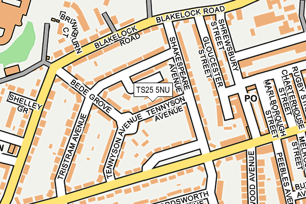
TS25 5NU lies on Tennyson Avenue in Hartlepool. TS25 5NU is located in the Manor House electoral ward, within the unitary authority of Hartlepool and the English Parliamentary constituency of Hartlepool. The Sub Integrated Care Board (ICB) Location is NHS North East and North Cumbria ICB - 16C and the police force is Cleveland. This postcode has been in use since January 1980.


GetTheData
Source: OS OpenMap – Local (Ordnance Survey)
Source: OS VectorMap District (Ordnance Survey)
Licence: Open Government Licence (requires attribution)
| Easting | 450018 |
| Northing | 531369 |
| Latitude | 54.674912 |
| Longitude | -1.225877 |
GetTheData
Source: Open Postcode Geo
Licence: Open Government Licence
| Street | Tennyson Avenue |
| Town/City | Hartlepool |
| Country | England |
| Postcode District | TS25 |
➜ See where TS25 is on a map ➜ Where is Hartlepool? | |
GetTheData
Source: Land Registry Price Paid Data
Licence: Open Government Licence
Elevation or altitude of TS25 5NU as distance above sea level:
| Metres | Feet | |
|---|---|---|
| Elevation | 20m | 66ft |
Elevation is measured from the approximate centre of the postcode, to the nearest point on an OS contour line from OS Terrain 50, which has contour spacing of ten vertical metres.
➜ How high above sea level am I? Find the elevation of your current position using your device's GPS.
GetTheData
Source: Open Postcode Elevation
Licence: Open Government Licence
| Ward | Manor House |
| Constituency | Hartlepool |
GetTheData
Source: ONS Postcode Database
Licence: Open Government Licence
| Shakespeare Avenue (Oxford Road) | Foggy Furze | 135m |
| Bowling Green (Shrewsbury Street) | Foggy Furze | 166m |
| Shakespeare Avenue (Oxford Road) | Foggy Furze | 186m |
| Bowling Green (Shrewsbury Street) | Foggy Furze | 197m |
| Tristram Avenue (Oxford Road) | Rifthouse | 231m |
| Hartlepool Station | 1.8km |
| Seaton Carew Station | 2.5km |
GetTheData
Source: NaPTAN
Licence: Open Government Licence
| Percentage of properties with Next Generation Access | 100.0% |
| Percentage of properties with Superfast Broadband | 100.0% |
| Percentage of properties with Ultrafast Broadband | 100.0% |
| Percentage of properties with Full Fibre Broadband | 0.0% |
Superfast Broadband is between 30Mbps and 300Mbps
Ultrafast Broadband is > 300Mbps
| Median download speed | 50.0Mbps |
| Average download speed | 75.3Mbps |
| Maximum download speed | 350.00Mbps |
| Median upload speed | 10.0Mbps |
| Average upload speed | 10.7Mbps |
| Maximum upload speed | 19.53Mbps |
| Percentage of properties unable to receive 2Mbps | 0.0% |
| Percentage of properties unable to receive 5Mbps | 0.0% |
| Percentage of properties unable to receive 10Mbps | 0.0% |
| Percentage of properties unable to receive 30Mbps | 0.0% |
GetTheData
Source: Ofcom
Licence: Ofcom Terms of Use (requires attribution)
Estimated total energy consumption in TS25 5NU by fuel type, 2015.
| Consumption (kWh) | 333,599 |
|---|---|
| Meter count | 24 |
| Mean (kWh/meter) | 13,900 |
| Median (kWh/meter) | 13,414 |
| Consumption (kWh) | 92,297 |
|---|---|
| Meter count | 24 |
| Mean (kWh/meter) | 3,846 |
| Median (kWh/meter) | 3,544 |
GetTheData
Source: Postcode level gas estimates: 2015 (experimental)
Source: Postcode level electricity estimates: 2015 (experimental)
Licence: Open Government Licence
GetTheData
Source: ONS Postcode Database
Licence: Open Government Licence


➜ Get more ratings from the Food Standards Agency
GetTheData
Source: Food Standards Agency
Licence: FSA terms & conditions
| Last Collection | |||
|---|---|---|---|
| Location | Mon-Fri | Sat | Distance |
| Rosebank, Ellwick Road | 18:00 | 12:30 | 557m |
| Eldon Grove Park Road | 18:00 | 12:30 | 814m |
| Clifton Avenue | 18:00 | 12:30 | 1,045m |
GetTheData
Source: Dracos
Licence: Creative Commons Attribution-ShareAlike
The below table lists the International Territorial Level (ITL) codes (formerly Nomenclature of Territorial Units for Statistics (NUTS) codes) and Local Administrative Units (LAU) codes for TS25 5NU:
| ITL 1 Code | Name |
|---|---|
| TLC | North East (England) |
| ITL 2 Code | Name |
| TLC1 | Tees Valley and Durham |
| ITL 3 Code | Name |
| TLC11 | Hartlepool and Stockton-on-Tees |
| LAU 1 Code | Name |
| E06000001 | Hartlepool |
GetTheData
Source: ONS Postcode Directory
Licence: Open Government Licence
The below table lists the Census Output Area (OA), Lower Layer Super Output Area (LSOA), and Middle Layer Super Output Area (MSOA) for TS25 5NU:
| Code | Name | |
|---|---|---|
| OA | E00060271 | |
| LSOA | E01011949 | Hartlepool 009A |
| MSOA | E02002491 | Hartlepool 009 |
GetTheData
Source: ONS Postcode Directory
Licence: Open Government Licence
| TS25 5PE | Tristram Avenue | 89m |
| TS25 5QE | Oxford Road | 99m |
| TS25 5NS | Shakespeare Avenue | 99m |
| TS25 5NT | Shakespeare Avenue | 100m |
| TS25 5NX | Tennyson Avenue | 107m |
| TS25 5QZ | Gloucester Street | 119m |
| TS25 5PG | Blakelock Road | 139m |
| TS25 5NR | Shakespeare Avenue | 142m |
| TS25 5PD | Bede Grove | 165m |
| TS25 5QA | Oxford Road | 174m |
GetTheData
Source: Open Postcode Geo; Land Registry Price Paid Data
Licence: Open Government Licence