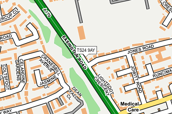
TS24 9AY is located in the De Bruce electoral ward, within the unitary authority of Hartlepool and the English Parliamentary constituency of Hartlepool. The Sub Integrated Care Board (ICB) Location is NHS North East and North Cumbria ICB - 16C and the police force is Cleveland. This postcode has been in use since January 1980.


GetTheData
Source: OS OpenMap – Local (Ordnance Survey)
Source: OS VectorMap District (Ordnance Survey)
Licence: Open Government Licence (requires attribution)
| Easting | 449476 |
| Northing | 534682 |
| Latitude | 54.704746 |
| Longitude | -1.233735 |
GetTheData
Source: Open Postcode Geo
Licence: Open Government Licence
| Country | England |
| Postcode District | TS24 |
➜ See where TS24 is on a map ➜ Where is Hartlepool? | |
GetTheData
Source: Land Registry Price Paid Data
Licence: Open Government Licence
Elevation or altitude of TS24 9AY as distance above sea level:
| Metres | Feet | |
|---|---|---|
| Elevation | 20m | 66ft |
Elevation is measured from the approximate centre of the postcode, to the nearest point on an OS contour line from OS Terrain 50, which has contour spacing of ten vertical metres.
➜ How high above sea level am I? Find the elevation of your current position using your device's GPS.
GetTheData
Source: Open Postcode Elevation
Licence: Open Government Licence
| Ward | De Bruce |
| Constituency | Hartlepool |
GetTheData
Source: ONS Postcode Database
Licence: Open Government Licence
| Lightfoot Crescent (Easington Road) | West View | 63m |
| Lightfoot Crescent (Easington Road) | West View | 128m |
| Mayfield Park (Easington Road) | West View | 149m |
| Mayfield Park (Easington Road) | West View | 150m |
| Hartfields Manor (Bluebell Way) | Throston Grange | 312m |
| Hartlepool Station | 2.6km |
GetTheData
Source: NaPTAN
Licence: Open Government Licence
| Percentage of properties with Next Generation Access | 100.0% |
| Percentage of properties with Superfast Broadband | 100.0% |
| Percentage of properties with Ultrafast Broadband | 100.0% |
| Percentage of properties with Full Fibre Broadband | 0.0% |
Superfast Broadband is between 30Mbps and 300Mbps
Ultrafast Broadband is > 300Mbps
| Percentage of properties unable to receive 2Mbps | 0.0% |
| Percentage of properties unable to receive 5Mbps | 0.0% |
| Percentage of properties unable to receive 10Mbps | 0.0% |
| Percentage of properties unable to receive 30Mbps | 0.0% |
GetTheData
Source: Ofcom
Licence: Ofcom Terms of Use (requires attribution)
GetTheData
Source: ONS Postcode Database
Licence: Open Government Licence


➜ Get more ratings from the Food Standards Agency
GetTheData
Source: Food Standards Agency
Licence: FSA terms & conditions
| Last Collection | |||
|---|---|---|---|
| Location | Mon-Fri | Sat | Distance |
| Elmwood Road | 17:30 | 12:30 | 1,242m |
| Brougham Terrace | 18:00 | 12:15 | 1,641m |
| Park Road | 18:00 | 12:30 | 1,707m |
GetTheData
Source: Dracos
Licence: Creative Commons Attribution-ShareAlike
The below table lists the International Territorial Level (ITL) codes (formerly Nomenclature of Territorial Units for Statistics (NUTS) codes) and Local Administrative Units (LAU) codes for TS24 9AY:
| ITL 1 Code | Name |
|---|---|
| TLC | North East (England) |
| ITL 2 Code | Name |
| TLC1 | Tees Valley and Durham |
| ITL 3 Code | Name |
| TLC11 | Hartlepool and Stockton-on-Tees |
| LAU 1 Code | Name |
| E06000001 | Hartlepool |
GetTheData
Source: ONS Postcode Directory
Licence: Open Government Licence
The below table lists the Census Output Area (OA), Lower Layer Super Output Area (LSOA), and Middle Layer Super Output Area (MSOA) for TS24 9AY:
| Code | Name | |
|---|---|---|
| OA | E00060283 | |
| LSOA | E01011952 | Hartlepool 002A |
| MSOA | E02002484 | Hartlepool 002 |
GetTheData
Source: ONS Postcode Directory
Licence: Open Government Licence
| TS24 9BB | Jones Road | 72m |
| TS24 9AX | Lightfoot Crescent | 125m |
| TS26 0ZQ | Cranesbill Avenue | 145m |
| TS24 9BQ | Bulmer Place | 160m |
| TS26 0ZP | Jasmine Close | 176m |
| TS24 9BE | Jowitt Road | 176m |
| TS26 0NY | Dean Fall Close | 188m |
| TS26 0NX | Ring Stone Close | 193m |
| TS24 9BJ | Horsley Place | 197m |
| TS26 0FD | Speedwell Close | 209m |
GetTheData
Source: Open Postcode Geo; Land Registry Price Paid Data
Licence: Open Government Licence