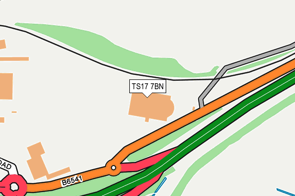
TS17 7BN lies on Middlesbrough Road in Thornaby, Stockton-on-tees. TS17 7BN is located in the Mandale & Victoria electoral ward, within the unitary authority of Stockton-on-Tees and the English Parliamentary constituency of Stockton South. The Sub Integrated Care Board (ICB) Location is NHS North East and North Cumbria ICB - 16C and the police force is Cleveland. This postcode has been in use since January 1980.


GetTheData
Source: OS OpenMap – Local (Ordnance Survey)
Source: OS VectorMap District (Ordnance Survey)
Licence: Open Government Licence (requires attribution)
| Easting | 445877 |
| Northing | 518354 |
| Latitude | 54.558352 |
| Longitude | -1.292119 |
GetTheData
Source: Open Postcode Geo
Licence: Open Government Licence
| Street | Middlesbrough Road |
| Locality | Thornaby |
| Town/City | Stockton-on-tees |
| Country | England |
| Postcode District | TS17 |
➜ See where TS17 is on a map ➜ Where is Thornaby-on-Tees? | |
GetTheData
Source: Land Registry Price Paid Data
Licence: Open Government Licence
Elevation or altitude of TS17 7BN as distance above sea level:
| Metres | Feet | |
|---|---|---|
| Elevation | 10m | 33ft |
Elevation is measured from the approximate centre of the postcode, to the nearest point on an OS contour line from OS Terrain 50, which has contour spacing of ten vertical metres.
➜ How high above sea level am I? Find the elevation of your current position using your device's GPS.
GetTheData
Source: Open Postcode Elevation
Licence: Open Government Licence
| Ward | Mandale & Victoria |
| Constituency | Stockton South |
GetTheData
Source: ONS Postcode Database
Licence: Open Government Licence
| Total Fitness (Middlesbrough Road) | Teesdale | 99m |
| Total Fitness (Middlesbrough Road) | Teesdale | 191m |
| Bon Lea (Mandale Road) | Thornaby | 391m |
| Queen's Campus (Princeton Drive) | Teesdale | 410m |
| Queen's Campus (Princeton Drive) | Teesdale | 439m |
| Thornaby Station | 0.6km |
| Stockton Station | 2.1km |
| Middlesbrough Station | 4.4km |
GetTheData
Source: NaPTAN
Licence: Open Government Licence
GetTheData
Source: ONS Postcode Database
Licence: Open Government Licence


➜ Get more ratings from the Food Standards Agency
GetTheData
Source: Food Standards Agency
Licence: FSA terms & conditions
| Last Collection | |||
|---|---|---|---|
| Location | Mon-Fri | Sat | Distance |
| Mandale Road | 17:45 | 11:00 | 591m |
| Harvard Avenue | 17:30 | 11:00 | 676m |
| High Street West | 17:30 | 12:30 | 679m |
GetTheData
Source: Dracos
Licence: Creative Commons Attribution-ShareAlike
The below table lists the International Territorial Level (ITL) codes (formerly Nomenclature of Territorial Units for Statistics (NUTS) codes) and Local Administrative Units (LAU) codes for TS17 7BN:
| ITL 1 Code | Name |
|---|---|
| TLC | North East (England) |
| ITL 2 Code | Name |
| TLC1 | Tees Valley and Durham |
| ITL 3 Code | Name |
| TLC11 | Hartlepool and Stockton-on-Tees |
| LAU 1 Code | Name |
| E06000004 | Stockton-on-Tees |
GetTheData
Source: ONS Postcode Directory
Licence: Open Government Licence
The below table lists the Census Output Area (OA), Lower Layer Super Output Area (LSOA), and Middle Layer Super Output Area (MSOA) for TS17 7BN:
| Code | Name | |
|---|---|---|
| OA | E00061956 | |
| LSOA | E01012286 | Stockton-on-Tees 017A |
| MSOA | E02002551 | Stockton-on-Tees 017 |
GetTheData
Source: ONS Postcode Directory
Licence: Open Government Licence
| TS17 7AR | Wilson Street | 337m |
| TS17 7BD | Acklam Road | 348m |
| TS17 7EW | Anderson Road | 402m |
| TS17 7EL | Derby Terrace | 421m |
| TS17 7EG | Mansfield Avenue | 440m |
| TS17 7AQ | Bonlea Trading Estate | 446m |
| TS17 7ET | Cobden Street | 449m |
| TS17 7EP | Cobden Street | 452m |
| TS17 7HB | St Lukes Avenue | 460m |
| TS17 7ED | Cranworth Green | 464m |
GetTheData
Source: Open Postcode Geo; Land Registry Price Paid Data
Licence: Open Government Licence