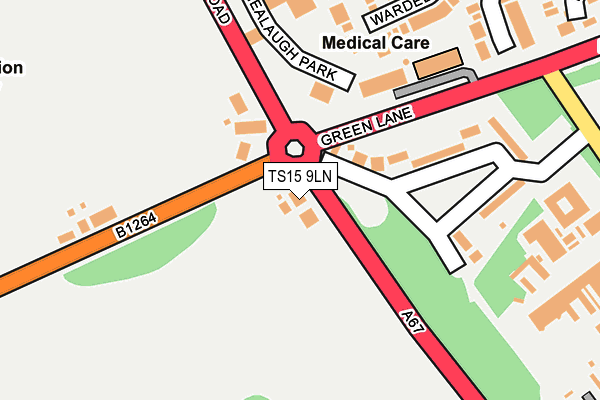
TS15 9LN lies on Lane End Cottages in Kirklevington, Yarm. TS15 9LN is located in the Yarm electoral ward, within the unitary authority of Stockton-on-Tees and the English Parliamentary constituency of Stockton South. The Sub Integrated Care Board (ICB) Location is NHS North East and North Cumbria ICB - 16C and the police force is Cleveland. This postcode has been in use since January 1980.


GetTheData
Source: OS OpenMap – Local (Ordnance Survey)
Source: OS VectorMap District (Ordnance Survey)
Licence: Open Government Licence (requires attribution)
| Easting | 442596 |
| Northing | 511365 |
| Latitude | 54.495833 |
| Longitude | -1.343856 |
GetTheData
Source: Open Postcode Geo
Licence: Open Government Licence
| Street | Lane End Cottages |
| Locality | Kirklevington |
| Town/City | Yarm |
| Country | England |
| Postcode District | TS15 |
➜ See where TS15 is on a map ➜ Where is Yarm? | |
GetTheData
Source: Land Registry Price Paid Data
Licence: Open Government Licence
Elevation or altitude of TS15 9LN as distance above sea level:
| Metres | Feet | |
|---|---|---|
| Elevation | 40m | 131ft |
Elevation is measured from the approximate centre of the postcode, to the nearest point on an OS contour line from OS Terrain 50, which has contour spacing of ten vertical metres.
➜ How high above sea level am I? Find the elevation of your current position using your device's GPS.
GetTheData
Source: Open Postcode Elevation
Licence: Open Government Licence
| Ward | Yarm |
| Constituency | Stockton South |
GetTheData
Source: ONS Postcode Database
Licence: Open Government Licence
| Hmp Kirklevington Grange (Thirsk Road) | Kirklevington Grange | 37m |
| Green Lane | Kirklevington Grange | 95m |
| Hmp Kirklevington Grange (Thirsk Road) | Kirklevington Grange | 114m |
| Wycliffe Court (Green Lane) | Kirklevington Grange | 123m |
| Thirsk Road Garage (Thirsk Road) | Kirklevington Grange | 177m |
| Yarm Station | 0.5km |
| Allens West Station | 3.4km |
| Eaglescliffe Station | 3.8km |
GetTheData
Source: NaPTAN
Licence: Open Government Licence
| Percentage of properties with Next Generation Access | 100.0% |
| Percentage of properties with Superfast Broadband | 100.0% |
| Percentage of properties with Ultrafast Broadband | 0.0% |
| Percentage of properties with Full Fibre Broadband | 0.0% |
Superfast Broadband is between 30Mbps and 300Mbps
Ultrafast Broadband is > 300Mbps
| Percentage of properties unable to receive 2Mbps | 0.0% |
| Percentage of properties unable to receive 5Mbps | 0.0% |
| Percentage of properties unable to receive 10Mbps | 0.0% |
| Percentage of properties unable to receive 30Mbps | 0.0% |
GetTheData
Source: Ofcom
Licence: Ofcom Terms of Use (requires attribution)
GetTheData
Source: ONS Postcode Database
Licence: Open Government Licence


➜ Get more ratings from the Food Standards Agency
GetTheData
Source: Food Standards Agency
Licence: FSA terms & conditions
| Last Collection | |||
|---|---|---|---|
| Location | Mon-Fri | Sat | Distance |
| Davenport Road | 16:45 | 10:30 | 741m |
| Fauconberg Way | 17:00 | 10:15 | 1,136m |
| Low Worsall | 16:45 | 10:15 | 1,282m |
GetTheData
Source: Dracos
Licence: Creative Commons Attribution-ShareAlike
The below table lists the International Territorial Level (ITL) codes (formerly Nomenclature of Territorial Units for Statistics (NUTS) codes) and Local Administrative Units (LAU) codes for TS15 9LN:
| ITL 1 Code | Name |
|---|---|
| TLC | North East (England) |
| ITL 2 Code | Name |
| TLC1 | Tees Valley and Durham |
| ITL 3 Code | Name |
| TLC11 | Hartlepool and Stockton-on-Tees |
| LAU 1 Code | Name |
| E06000004 | Stockton-on-Tees |
GetTheData
Source: ONS Postcode Directory
Licence: Open Government Licence
The below table lists the Census Output Area (OA), Lower Layer Super Output Area (LSOA), and Middle Layer Super Output Area (MSOA) for TS15 9LN:
| Code | Name | |
|---|---|---|
| OA | E00174174 | |
| LSOA | E01012235 | Stockton-on-Tees 024A |
| MSOA | E02002558 | Stockton-on-Tees 024 |
GetTheData
Source: ONS Postcode Directory
Licence: Open Government Licence
| TS15 9LJ | Thirsk Road | 93m |
| TS15 9XD | Wycliffe Court | 138m |
| TS15 9LL | Kirklevington Grange | 159m |
| TS15 9UZ | Wardell Close | 200m |
| TS15 9UY | Nursery Gardens | 266m |
| TS15 9XE | Canon Grove | 344m |
| TS15 9XA | The Rigg | 355m |
| TS15 9EH | Green Lane | 356m |
| TS15 9SS | Hugill Close | 365m |
| TS15 9UP | Howden Dike | 387m |
GetTheData
Source: Open Postcode Geo; Land Registry Price Paid Data
Licence: Open Government Licence