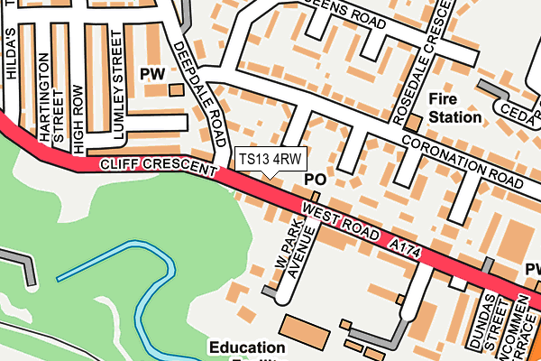
TS13 4RW lies on West Road in Loftus, Saltburn-by-the-sea. TS13 4RW is located in the Loftus electoral ward, within the unitary authority of Redcar and Cleveland and the English Parliamentary constituency of Middlesbrough South and East Cleveland. The Sub Integrated Care Board (ICB) Location is NHS North East and North Cumbria ICB - 16C and the police force is Cleveland. This postcode has been in use since January 1980.


GetTheData
Source: OS OpenMap – Local (Ordnance Survey)
Source: OS VectorMap District (Ordnance Survey)
Licence: Open Government Licence (requires attribution)
| Easting | 471549 |
| Northing | 518386 |
| Latitude | 54.555667 |
| Longitude | -0.895213 |
GetTheData
Source: Open Postcode Geo
Licence: Open Government Licence
| Street | West Road |
| Locality | Loftus |
| Town/City | Saltburn-by-the-sea |
| Country | England |
| Postcode District | TS13 |
➜ See where TS13 is on a map ➜ Where is Loftus? | |
GetTheData
Source: Land Registry Price Paid Data
Licence: Open Government Licence
Elevation or altitude of TS13 4RW as distance above sea level:
| Metres | Feet | |
|---|---|---|
| Elevation | 70m | 230ft |
Elevation is measured from the approximate centre of the postcode, to the nearest point on an OS contour line from OS Terrain 50, which has contour spacing of ten vertical metres.
➜ How high above sea level am I? Find the elevation of your current position using your device's GPS.
GetTheData
Source: Open Postcode Elevation
Licence: Open Government Licence
| Ward | Loftus |
| Constituency | Middlesbrough South And East Cleveland |
GetTheData
Source: ONS Postcode Database
Licence: Open Government Licence
| Post Office (West Road) | Loftus | 51m |
| Post Office (West Road) | Loftus | 71m |
| Harry Dack School | Loftus | 82m |
| Bank Top (Loftus Bank) | Loftus | 165m |
| Coronation Road (Rosedale Crescent) | Loftus | 167m |
GetTheData
Source: NaPTAN
Licence: Open Government Licence
| Percentage of properties with Next Generation Access | 100.0% |
| Percentage of properties with Superfast Broadband | 100.0% |
| Percentage of properties with Ultrafast Broadband | 100.0% |
| Percentage of properties with Full Fibre Broadband | 0.0% |
Superfast Broadband is between 30Mbps and 300Mbps
Ultrafast Broadband is > 300Mbps
| Median download speed | 20.7Mbps |
| Average download speed | 58.0Mbps |
| Maximum download speed | 200.00Mbps |
| Median upload speed | 1.2Mbps |
| Average upload speed | 1.1Mbps |
| Maximum upload speed | 1.22Mbps |
| Percentage of properties unable to receive 2Mbps | 0.0% |
| Percentage of properties unable to receive 5Mbps | 0.0% |
| Percentage of properties unable to receive 10Mbps | 0.0% |
| Percentage of properties unable to receive 30Mbps | 0.0% |
GetTheData
Source: Ofcom
Licence: Ofcom Terms of Use (requires attribution)
Estimated total energy consumption in TS13 4RW by fuel type, 2015.
| Consumption (kWh) | 216,641 |
|---|---|
| Meter count | 16 |
| Mean (kWh/meter) | 13,540 |
| Median (kWh/meter) | 12,304 |
| Consumption (kWh) | 69,084 |
|---|---|
| Meter count | 19 |
| Mean (kWh/meter) | 3,636 |
| Median (kWh/meter) | 3,817 |
GetTheData
Source: Postcode level gas estimates: 2015 (experimental)
Source: Postcode level electricity estimates: 2015 (experimental)
Licence: Open Government Licence
GetTheData
Source: ONS Postcode Database
Licence: Open Government Licence


➜ Get more ratings from the Food Standards Agency
GetTheData
Source: Food Standards Agency
Licence: FSA terms & conditions
The below table lists the International Territorial Level (ITL) codes (formerly Nomenclature of Territorial Units for Statistics (NUTS) codes) and Local Administrative Units (LAU) codes for TS13 4RW:
| ITL 1 Code | Name |
|---|---|
| TLC | North East (England) |
| ITL 2 Code | Name |
| TLC1 | Tees Valley and Durham |
| ITL 3 Code | Name |
| TLC12 | South Teesside |
| LAU 1 Code | Name |
| E06000003 | Redcar and Cleveland |
GetTheData
Source: ONS Postcode Directory
Licence: Open Government Licence
The below table lists the Census Output Area (OA), Lower Layer Super Output Area (LSOA), and Middle Layer Super Output Area (MSOA) for TS13 4RW:
| Code | Name | |
|---|---|---|
| OA | E00061194 | |
| LSOA | E01033473 | Redcar and Cleveland 013E |
| MSOA | E02002527 | Redcar and Cleveland 013 |
GetTheData
Source: ONS Postcode Directory
Licence: Open Government Licence
| TS13 4RN | West Road | 37m |
| TS13 4SN | Coronation Road | 61m |
| TS13 4RR | Co Operative Close | 62m |
| TS13 4RL | West Park Avenue | 107m |
| TS13 4SL | Coronation Road | 114m |
| TS13 4RP | West Road | 118m |
| TS13 4RY | Cliff Crescent | 143m |
| TS13 4RX | Scarborough Street | 144m |
| TS13 4RH | West Road | 153m |
| TS13 4SW | Coronation Road | 167m |
GetTheData
Source: Open Postcode Geo; Land Registry Price Paid Data
Licence: Open Government Licence