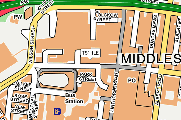
TS1 1LE lies on Newport Road in Middlesbrough. TS1 1LE is located in the Central electoral ward, within the unitary authority of Middlesbrough and the English Parliamentary constituency of Middlesbrough. The Sub Integrated Care Board (ICB) Location is NHS North East and North Cumbria ICB - 16C and the police force is Cleveland. This postcode has been in use since January 1980.


GetTheData
Source: OS OpenMap – Local (Ordnance Survey)
Source: OS VectorMap District (Ordnance Survey)
Licence: Open Government Licence (requires attribution)
| Easting | 449349 |
| Northing | 520424 |
| Latitude | 54.576640 |
| Longitude | -1.238104 |
GetTheData
Source: Open Postcode Geo
Licence: Open Government Licence
| Street | Newport Road |
| Town/City | Middlesbrough |
| Country | England |
| Postcode District | TS1 |
➜ See where TS1 is on a map ➜ Where is Middlesbrough? | |
GetTheData
Source: Land Registry Price Paid Data
Licence: Open Government Licence
Elevation or altitude of TS1 1LE as distance above sea level:
| Metres | Feet | |
|---|---|---|
| Elevation | 10m | 33ft |
Elevation is measured from the approximate centre of the postcode, to the nearest point on an OS contour line from OS Terrain 50, which has contour spacing of ten vertical metres.
➜ How high above sea level am I? Find the elevation of your current position using your device's GPS.
GetTheData
Source: Open Postcode Elevation
Licence: Open Government Licence
| Ward | Central |
| Constituency | Middlesbrough |
GetTheData
Source: ONS Postcode Database
Licence: Open Government Licence
| Bus Station Express Lounge (Newport Road) | Middlesbrough | 100m |
| Bus Station Stand 11 (Newport Road) | Middlesbrough | 106m |
| Bus Station Stand 10 (Newport Road) | Middlesbrough | 113m |
| Bus Station Stand 1 (Newport Road) | Middlesbrough | 116m |
| Bus Station Stand 9 (Newport Road) | Middlesbrough | 123m |
| Middlesbrough Station | 0.4km |
| James Cook University Hospital Station | 3.3km |
| South Bank Station | 4.1km |
GetTheData
Source: NaPTAN
Licence: Open Government Licence
| Median download speed | 11.3Mbps |
| Average download speed | 22.1Mbps |
| Maximum download speed | 73.17Mbps |
| Median upload speed | 1.0Mbps |
| Average upload speed | 4.6Mbps |
| Maximum upload speed | 19.77Mbps |
GetTheData
Source: Ofcom
Licence: Ofcom Terms of Use (requires attribution)
GetTheData
Source: ONS Postcode Database
Licence: Open Government Licence

➜ Get more ratings from the Food Standards Agency
GetTheData
Source: Food Standards Agency
Licence: FSA terms & conditions
| Last Collection | |||
|---|---|---|---|
| Location | Mon-Fri | Sat | Distance |
| Boundary Road | 18:30 | 13:00 | 143m |
| Corporation Road | 18:30 | 12:30 | 172m |
| Branch Office | 17:30 | 12:30 | 181m |
GetTheData
Source: Dracos
Licence: Creative Commons Attribution-ShareAlike
The below table lists the International Territorial Level (ITL) codes (formerly Nomenclature of Territorial Units for Statistics (NUTS) codes) and Local Administrative Units (LAU) codes for TS1 1LE:
| ITL 1 Code | Name |
|---|---|
| TLC | North East (England) |
| ITL 2 Code | Name |
| TLC1 | Tees Valley and Durham |
| ITL 3 Code | Name |
| TLC12 | South Teesside |
| LAU 1 Code | Name |
| E06000002 | Middlesbrough |
GetTheData
Source: ONS Postcode Directory
Licence: Open Government Licence
The below table lists the Census Output Area (OA), Lower Layer Super Output Area (LSOA), and Middle Layer Super Output Area (MSOA) for TS1 1LE:
| Code | Name | |
|---|---|---|
| OA | E00174105 | |
| LSOA | E01033468 | Middlesbrough 001G |
| MSOA | E02002496 | Middlesbrough 001 |
GetTheData
Source: ONS Postcode Directory
Licence: Open Government Licence
| TS1 5EP | Newport Crescent | 93m |
| TS1 5BS | Linthorpe Road | 99m |
| TS1 1LB | Newport Road | 119m |
| TS1 1RA | Linthorpe Road | 120m |
| TS1 5ET | Gilkes Street | 136m |
| TS1 1SU | Hill Street Shopping Centre | 143m |
| TS1 1RD | Linthorpe Road | 160m |
| TS1 1LA | Newport Road | 181m |
| TS1 1LP | Corporation Road | 200m |
| TS1 5AS | Grange Road | 220m |
GetTheData
Source: Open Postcode Geo; Land Registry Price Paid Data
Licence: Open Government Licence