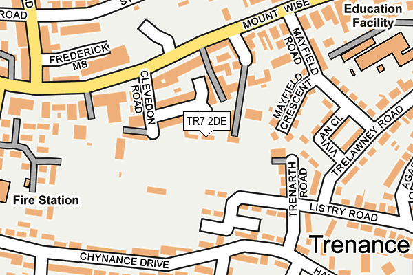
TR7 2DE lies on Chegwin Court in Newquay. TR7 2DE is located in the Newquay Trenance electoral ward, within the unitary authority of Cornwall and the English Parliamentary constituency of St Austell and Newquay. The Sub Integrated Care Board (ICB) Location is NHS Cornwall and the Isles of Scilly ICB - 11N and the police force is Devon & Cornwall. This postcode has been in use since February 2007.


GetTheData
Source: OS OpenMap – Local (Ordnance Survey)
Source: OS VectorMap District (Ordnance Survey)
Licence: Open Government Licence (requires attribution)
| Easting | 181015 |
| Northing | 61263 |
| Latitude | 50.410326 |
| Longitude | -5.083439 |
GetTheData
Source: Open Postcode Geo
Licence: Open Government Licence
| Street | Chegwin Court |
| Town/City | Newquay |
| Country | England |
| Postcode District | TR7 |
➜ See where TR7 is on a map ➜ Where is Newquay? | |
GetTheData
Source: Land Registry Price Paid Data
Licence: Open Government Licence
Elevation or altitude of TR7 2DE as distance above sea level:
| Metres | Feet | |
|---|---|---|
| Elevation | 60m | 197ft |
Elevation is measured from the approximate centre of the postcode, to the nearest point on an OS contour line from OS Terrain 50, which has contour spacing of ten vertical metres.
➜ How high above sea level am I? Find the elevation of your current position using your device's GPS.
GetTheData
Source: Open Postcode Elevation
Licence: Open Government Licence
| Ward | Newquay Trenance |
| Constituency | St Austell And Newquay |
GetTheData
Source: ONS Postcode Database
Licence: Open Government Licence
| Windsor Court (Mount Wise) | Newquay | 170m |
| Chynance Drive (Chynance Drive Road) | Trenance | 177m |
| Vivian Close (Trelawney Road) | Trenance | 207m |
| Chynance Drive (Chynance Drive Road) | Trenance | 212m |
| Listry Road | Trenance | 236m |
| Newquay Station | 0.8km |
| Quintrell Downs Station | 4km |
GetTheData
Source: NaPTAN
Licence: Open Government Licence
| Percentage of properties with Next Generation Access | 0.0% |
| Percentage of properties with Superfast Broadband | 0.0% |
| Percentage of properties with Ultrafast Broadband | 0.0% |
| Percentage of properties with Full Fibre Broadband | 0.0% |
Superfast Broadband is between 30Mbps and 300Mbps
Ultrafast Broadband is > 300Mbps
| Percentage of properties unable to receive 2Mbps | 0.0% |
| Percentage of properties unable to receive 5Mbps | 0.0% |
| Percentage of properties unable to receive 10Mbps | 0.0% |
| Percentage of properties unable to receive 30Mbps | 100.0% |
GetTheData
Source: Ofcom
Licence: Ofcom Terms of Use (requires attribution)
Estimated total energy consumption in TR7 2DE by fuel type, 2015.
| Consumption (kWh) | 21,598 |
|---|---|
| Meter count | 6 |
| Mean (kWh/meter) | 3,600 |
| Median (kWh/meter) | 2,275 |
| Consumption (kWh) | 8,602 |
|---|---|
| Meter count | 6 |
| Mean (kWh/meter) | 1,434 |
| Median (kWh/meter) | 1,560 |
GetTheData
Source: Postcode level gas estimates: 2015 (experimental)
Source: Postcode level electricity estimates: 2015 (experimental)
Licence: Open Government Licence
GetTheData
Source: ONS Postcode Database
Licence: Open Government Licence


➜ Get more ratings from the Food Standards Agency
GetTheData
Source: Food Standards Agency
Licence: FSA terms & conditions
| Last Collection | |||
|---|---|---|---|
| Location | Mon-Fri | Sat | Distance |
| Listry Road | 17:30 | 11:00 | 204m |
| St Georges Road | 17:35 | 11:00 | 294m |
| Tregunnel Hill | 17:40 | 08:30 | 299m |
GetTheData
Source: Dracos
Licence: Creative Commons Attribution-ShareAlike
The below table lists the International Territorial Level (ITL) codes (formerly Nomenclature of Territorial Units for Statistics (NUTS) codes) and Local Administrative Units (LAU) codes for TR7 2DE:
| ITL 1 Code | Name |
|---|---|
| TLK | South West (England) |
| ITL 2 Code | Name |
| TLK3 | Cornwall and Isles of Scilly |
| ITL 3 Code | Name |
| TLK30 | Cornwall and Isles of Scilly |
| LAU 1 Code | Name |
| E06000052 | Cornwall |
GetTheData
Source: ONS Postcode Directory
Licence: Open Government Licence
The below table lists the Census Output Area (OA), Lower Layer Super Output Area (LSOA), and Middle Layer Super Output Area (MSOA) for TR7 2DE:
| Code | Name | |
|---|---|---|
| OA | E00096165 | |
| LSOA | E01019028 | Cornwall 020A |
| MSOA | E02003954 | Cornwall 020 |
GetTheData
Source: ONS Postcode Directory
Licence: Open Government Licence
| TR7 2BU | Clevedon Road | 54m |
| TR7 2DA | Chegwin Gardens | 75m |
| TR7 2BP | Mount Wise | 107m |
| TR7 2DR | Listry Road | 113m |
| TR7 2DH | Mayfield Crescent | 121m |
| TR7 2DU | Trenarth Road | 125m |
| TR7 2BX | Mountwise Cottages | 128m |
| TR7 2DD | Windsor Court | 146m |
| TR7 2BL | Mount Wise | 150m |
| TR7 2BW | Lindy Place | 153m |
GetTheData
Source: Open Postcode Geo; Land Registry Price Paid Data
Licence: Open Government Licence