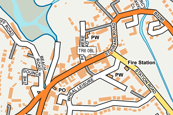
TR6 0BL lies on St Pirans Parade in Perranporth. TR6 0BL is located in the Perranporth electoral ward, within the unitary authority of Cornwall and the English Parliamentary constituency of Truro and Falmouth. The Sub Integrated Care Board (ICB) Location is NHS Cornwall and the Isles of Scilly ICB - 11N and the police force is Devon & Cornwall. This postcode has been in use since January 1980.


GetTheData
Source: OS OpenMap – Local (Ordnance Survey)
Source: OS VectorMap District (Ordnance Survey)
Licence: Open Government Licence (requires attribution)
| Easting | 175823 |
| Northing | 54280 |
| Latitude | 50.345654 |
| Longitude | -5.152281 |
GetTheData
Source: Open Postcode Geo
Licence: Open Government Licence
| Street | St Pirans Parade |
| Town/City | Perranporth |
| Country | England |
| Postcode District | TR6 |
➜ See where TR6 is on a map ➜ Where is Perranporth? | |
GetTheData
Source: Land Registry Price Paid Data
Licence: Open Government Licence
Elevation or altitude of TR6 0BL as distance above sea level:
| Metres | Feet | |
|---|---|---|
| Elevation | 10m | 33ft |
Elevation is measured from the approximate centre of the postcode, to the nearest point on an OS contour line from OS Terrain 50, which has contour spacing of ten vertical metres.
➜ How high above sea level am I? Find the elevation of your current position using your device's GPS.
GetTheData
Source: Open Postcode Elevation
Licence: Open Government Licence
| Ward | Perranporth |
| Constituency | Truro And Falmouth |
GetTheData
Source: ONS Postcode Database
Licence: Open Government Licence
| Tregonning Court (St Pirans Road) | Perranporth | 54m |
| Tregonning Court (St Pirans Road) | Perranporth | 57m |
| Church (Wheal Leisure) | Perranporth | 87m |
| Fire Station | Perranporth | 127m |
| Fire Station (Wheal Leisure) | Perranporth | 128m |
GetTheData
Source: NaPTAN
Licence: Open Government Licence
| Percentage of properties with Next Generation Access | 0.0% |
| Percentage of properties with Superfast Broadband | 0.0% |
| Percentage of properties with Ultrafast Broadband | 0.0% |
| Percentage of properties with Full Fibre Broadband | 0.0% |
Superfast Broadband is between 30Mbps and 300Mbps
Ultrafast Broadband is > 300Mbps
| Median download speed | 20.4Mbps |
| Average download speed | 20.7Mbps |
| Maximum download speed | 24.38Mbps |
| Median upload speed | 1.1Mbps |
| Average upload speed | 1.1Mbps |
| Maximum upload speed | 1.25Mbps |
| Percentage of properties unable to receive 2Mbps | 0.0% |
| Percentage of properties unable to receive 5Mbps | 0.0% |
| Percentage of properties unable to receive 10Mbps | 0.0% |
| Percentage of properties unable to receive 30Mbps | 100.0% |
GetTheData
Source: Ofcom
Licence: Ofcom Terms of Use (requires attribution)
GetTheData
Source: ONS Postcode Database
Licence: Open Government Licence


➜ Get more ratings from the Food Standards Agency
GetTheData
Source: Food Standards Agency
Licence: FSA terms & conditions
| Last Collection | |||
|---|---|---|---|
| Location | Mon-Fri | Sat | Distance |
| Goonhavern Post Office | 17:00 | 11:30 | 3,108m |
| Ellenglaze | 09:30 | 09:30 | 3,962m |
| Hendra Croft | 16:15 | 10:50 | 4,394m |
GetTheData
Source: Dracos
Licence: Creative Commons Attribution-ShareAlike
The below table lists the International Territorial Level (ITL) codes (formerly Nomenclature of Territorial Units for Statistics (NUTS) codes) and Local Administrative Units (LAU) codes for TR6 0BL:
| ITL 1 Code | Name |
|---|---|
| TLK | South West (England) |
| ITL 2 Code | Name |
| TLK3 | Cornwall and Isles of Scilly |
| ITL 3 Code | Name |
| TLK30 | Cornwall and Isles of Scilly |
| LAU 1 Code | Name |
| E06000052 | Cornwall |
GetTheData
Source: ONS Postcode Directory
Licence: Open Government Licence
The below table lists the Census Output Area (OA), Lower Layer Super Output Area (LSOA), and Middle Layer Super Output Area (MSOA) for TR6 0BL:
| Code | Name | |
|---|---|---|
| OA | E00095133 | |
| LSOA | E01018844 | Cornwall 033D |
| MSOA | E02003906 | Cornwall 033 |
GetTheData
Source: ONS Postcode Directory
Licence: Open Government Licence
| TR6 0BH | St Pirans Road | 37m |
| TR6 0BJ | St Pirans Road | 62m |
| TR6 0EZ | Wheal Leisure | 68m |
| TR6 0BW | Ponsmere Road | 81m |
| TR6 0BS | Eureka Vale | 117m |
| TR6 0BQ | Beach Lane | 129m |
| TR6 0EY | Wheal Leisure | 157m |
| TR6 0BT | Beach Bungalows | 183m |
| TR6 0JL | Beach Road | 184m |
| TR6 0LR | Station Road | 184m |
GetTheData
Source: Open Postcode Geo; Land Registry Price Paid Data
Licence: Open Government Licence