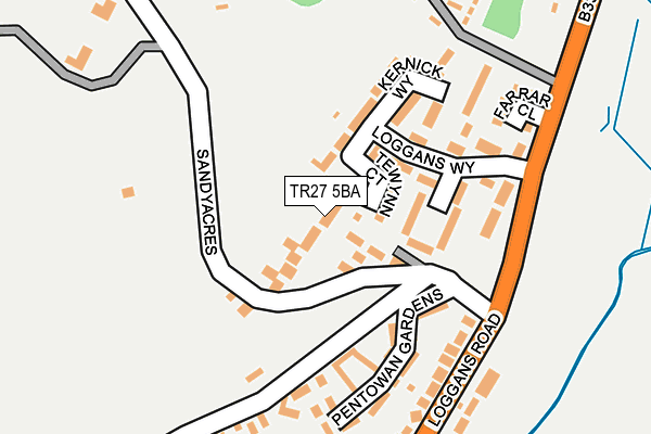
TR27 5BA lies on Sandyacres in Loggans, Hayle. TR27 5BA is located in the Gwinear-Gwithian & Hayle East electoral ward, within the unitary authority of Cornwall and the English Parliamentary constituency of Camborne and Redruth. The Sub Integrated Care Board (ICB) Location is NHS Cornwall and the Isles of Scilly ICB - 11N and the police force is Devon & Cornwall. This postcode has been in use since January 1980.


GetTheData
Source: OS OpenMap – Local (Ordnance Survey)
Source: OS VectorMap District (Ordnance Survey)
Licence: Open Government Licence (requires attribution)
| Easting | 157149 |
| Northing | 39022 |
| Latitude | 50.201271 |
| Longitude | -5.404486 |
GetTheData
Source: Open Postcode Geo
Licence: Open Government Licence
| Street | Sandyacres |
| Locality | Loggans |
| Town/City | Hayle |
| Country | England |
| Postcode District | TR27 |
➜ See where TR27 is on a map | |
GetTheData
Source: Land Registry Price Paid Data
Licence: Open Government Licence
Elevation or altitude of TR27 5BA as distance above sea level:
| Metres | Feet | |
|---|---|---|
| Elevation | 30m | 98ft |
Elevation is measured from the approximate centre of the postcode, to the nearest point on an OS contour line from OS Terrain 50, which has contour spacing of ten vertical metres.
➜ How high above sea level am I? Find the elevation of your current position using your device's GPS.
GetTheData
Source: Open Postcode Elevation
Licence: Open Government Licence
| Ward | Gwinear-gwithian & Hayle East |
| Constituency | Camborne And Redruth |
GetTheData
Source: ONS Postcode Database
Licence: Open Government Licence
| Loggans Way (Loggans Road) | Loggans Moor | 321m |
| Loggans Way (Logggans Road) | Loggans Moor | 338m |
| Lidl Loggans Road (Loggans Road) | Hayle | 584m |
| Lidl Loggans Road (Loggans Road) | Hayle | 588m |
| Lidl Carwin Rise (Carwin Rise) | Hayle | 592m |
| Hayle Station | 2.1km |
| Lelant Station | 3km |
| Lelant Saltings Station | 3.6km |
GetTheData
Source: NaPTAN
Licence: Open Government Licence
| Percentage of properties with Next Generation Access | 88.9% |
| Percentage of properties with Superfast Broadband | 88.9% |
| Percentage of properties with Ultrafast Broadband | 83.3% |
| Percentage of properties with Full Fibre Broadband | 83.3% |
Superfast Broadband is between 30Mbps and 300Mbps
Ultrafast Broadband is > 300Mbps
| Median download speed | 4.8Mbps |
| Average download speed | 4.2Mbps |
| Maximum download speed | 6.38Mbps |
| Median upload speed | 0.8Mbps |
| Average upload speed | 0.7Mbps |
| Maximum upload speed | 0.95Mbps |
| Percentage of properties unable to receive 2Mbps | 0.0% |
| Percentage of properties unable to receive 5Mbps | 0.0% |
| Percentage of properties unable to receive 10Mbps | 11.1% |
| Percentage of properties unable to receive 30Mbps | 11.1% |
GetTheData
Source: Ofcom
Licence: Ofcom Terms of Use (requires attribution)
Estimated total energy consumption in TR27 5BA by fuel type, 2015.
| Consumption (kWh) | 191,304 |
|---|---|
| Meter count | 11 |
| Mean (kWh/meter) | 17,391 |
| Median (kWh/meter) | 13,355 |
| Consumption (kWh) | 69,246 |
|---|---|
| Meter count | 17 |
| Mean (kWh/meter) | 4,073 |
| Median (kWh/meter) | 2,315 |
GetTheData
Source: Postcode level gas estimates: 2015 (experimental)
Source: Postcode level electricity estimates: 2015 (experimental)
Licence: Open Government Licence
GetTheData
Source: ONS Postcode Database
Licence: Open Government Licence


➜ Get more ratings from the Food Standards Agency
GetTheData
Source: Food Standards Agency
Licence: FSA terms & conditions
| Last Collection | |||
|---|---|---|---|
| Location | Mon-Fri | Sat | Distance |
| Caroline Row | 17:05 | 11:00 | 783m |
| Copper House Post Office | 17:00 | 11:15 | 1,187m |
| Belle Vue | 17:10 | 11:15 | 1,452m |
GetTheData
Source: Dracos
Licence: Creative Commons Attribution-ShareAlike
The below table lists the International Territorial Level (ITL) codes (formerly Nomenclature of Territorial Units for Statistics (NUTS) codes) and Local Administrative Units (LAU) codes for TR27 5BA:
| ITL 1 Code | Name |
|---|---|
| TLK | South West (England) |
| ITL 2 Code | Name |
| TLK3 | Cornwall and Isles of Scilly |
| ITL 3 Code | Name |
| TLK30 | Cornwall and Isles of Scilly |
| LAU 1 Code | Name |
| E06000052 | Cornwall |
GetTheData
Source: ONS Postcode Directory
Licence: Open Government Licence
The below table lists the Census Output Area (OA), Lower Layer Super Output Area (LSOA), and Middle Layer Super Output Area (MSOA) for TR27 5BA:
| Code | Name | |
|---|---|---|
| OA | E00095875 | |
| LSOA | E01018978 | Cornwall 057A |
| MSOA | E02003944 | Cornwall 057 |
GetTheData
Source: ONS Postcode Directory
Licence: Open Government Licence
| TR27 5BG | Kernick Way | 188m |
| TR27 5BQ | Loggans Walk | 245m |
| TR27 5BE | Loggans Way | 252m |
| TR27 5BB | Loggans Road | 314m |
| TR27 5AZ | Pentowan Gardens | 379m |
| TR27 5AR | Pentowan Road | 422m |
| TR27 4PL | Loggans Road | 428m |
| TR27 4QL | Gweal Gollas | 472m |
| TR27 4QJ | Gwarth An Dre | 479m |
| TR27 5AP | Lethlean Towans | 520m |
GetTheData
Source: Open Postcode Geo; Land Registry Price Paid Data
Licence: Open Government Licence