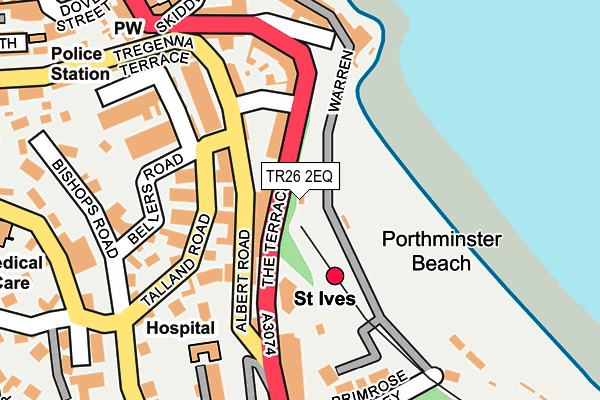
TR26 2EQ is located in the St Ives East, Lelant & Carbis Bay electoral ward, within the unitary authority of Cornwall and the English Parliamentary constituency of St Ives. The Sub Integrated Care Board (ICB) Location is NHS Cornwall and the Isles of Scilly ICB - 11N and the police force is Devon & Cornwall. This postcode has been in use since December 1997.


GetTheData
Source: OS OpenMap – Local (Ordnance Survey)
Source: OS VectorMap District (Ordnance Survey)
Licence: Open Government Licence (requires attribution)
| Easting | 151938 |
| Northing | 40167 |
| Latitude | 50.209398 |
| Longitude | -5.478064 |
GetTheData
Source: Open Postcode Geo
Licence: Open Government Licence
| Country | England |
| Postcode District | TR26 |
➜ See where TR26 is on a map ➜ Where is St Ives? | |
GetTheData
Source: Land Registry Price Paid Data
Licence: Open Government Licence
Elevation or altitude of TR26 2EQ as distance above sea level:
| Metres | Feet | |
|---|---|---|
| Elevation | 20m | 66ft |
Elevation is measured from the approximate centre of the postcode, to the nearest point on an OS contour line from OS Terrain 50, which has contour spacing of ten vertical metres.
➜ How high above sea level am I? Find the elevation of your current position using your device's GPS.
GetTheData
Source: Open Postcode Elevation
Licence: Open Government Licence
| Ward | St Ives East, Lelant & Carbis Bay |
| Constituency | St Ives |
GetTheData
Source: ONS Postcode Database
Licence: Open Government Licence
| Porthminster Hotel (The Terrace) | St Ives | 97m |
| Hospital (Talland Road) | St Ives | 172m |
| Bus Station | St Ives | 183m |
| Hospital (Trelyon Avenue) | St Ives | 205m |
| Royal Square (Gabriel Street) | St Ives | 329m |
| St Ives (Cornwall) Station | 0km |
| Carbis Bay Station | 1.7km |
| Lelant Station | 4.1km |
GetTheData
Source: NaPTAN
Licence: Open Government Licence
GetTheData
Source: ONS Postcode Database
Licence: Open Government Licence


➜ Get more ratings from the Food Standards Agency
GetTheData
Source: Food Standards Agency
Licence: FSA terms & conditions
| Last Collection | |||
|---|---|---|---|
| Location | Mon-Fri | Sat | Distance |
| Talland Road | 17:00 | 11:30 | 156m |
| Porthminster | 17:30 | 11:30 | 158m |
| Tregenna Terrace | 17:00 | 11:30 | 196m |
GetTheData
Source: Dracos
Licence: Creative Commons Attribution-ShareAlike
The below table lists the International Territorial Level (ITL) codes (formerly Nomenclature of Territorial Units for Statistics (NUTS) codes) and Local Administrative Units (LAU) codes for TR26 2EQ:
| ITL 1 Code | Name |
|---|---|
| TLK | South West (England) |
| ITL 2 Code | Name |
| TLK3 | Cornwall and Isles of Scilly |
| ITL 3 Code | Name |
| TLK30 | Cornwall and Isles of Scilly |
| LAU 1 Code | Name |
| E06000052 | Cornwall |
GetTheData
Source: ONS Postcode Directory
Licence: Open Government Licence
The below table lists the Census Output Area (OA), Lower Layer Super Output Area (LSOA), and Middle Layer Super Output Area (MSOA) for TR26 2EQ:
| Code | Name | |
|---|---|---|
| OA | E00096056 | |
| LSOA | E01019012 | Cornwall 054E |
| MSOA | E02003943 | Cornwall 054 |
GetTheData
Source: ONS Postcode Directory
Licence: Open Government Licence
| TR26 2BP | The Terrace | 53m |
| TR26 2FF | Albert Road | 76m |
| TR26 2EH | Albert Road | 78m |
| TR26 2GB | The Terrace | 96m |
| TR26 2DG | Talland Road | 105m |
| TR26 2FD | Talland Road | 110m |
| TR26 2DF | Talland Road | 121m |
| TR26 2FJ | Pednolver Terrace | 128m |
| TR26 2EJ | Albert Place | 139m |
| TR26 2EL | Pednolver Terrace | 144m |
GetTheData
Source: Open Postcode Geo; Land Registry Price Paid Data
Licence: Open Government Licence