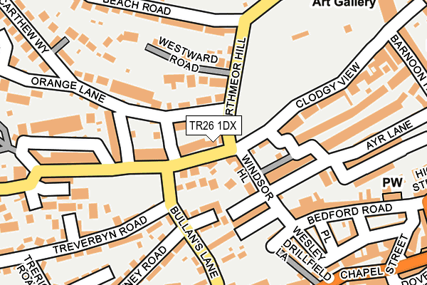
TR26 1DX lies on Ventnor Terrace in St Ives. TR26 1DX is located in the St Ives West & Towednack electoral ward, within the unitary authority of Cornwall and the English Parliamentary constituency of St Ives. The Sub Integrated Care Board (ICB) Location is NHS Cornwall and the Isles of Scilly ICB - 11N and the police force is Devon & Cornwall. This postcode has been in use since December 1998.


GetTheData
Source: OS OpenMap – Local (Ordnance Survey)
Source: OS VectorMap District (Ordnance Survey)
Licence: Open Government Licence (requires attribution)
| Easting | 151434 |
| Northing | 40556 |
| Latitude | 50.212678 |
| Longitude | -5.485369 |
GetTheData
Source: Open Postcode Geo
Licence: Open Government Licence
| Street | Ventnor Terrace |
| Town/City | St Ives |
| Country | England |
| Postcode District | TR26 |
➜ See where TR26 is on a map ➜ Where is St Ives? | |
GetTheData
Source: Land Registry Price Paid Data
Licence: Open Government Licence
Elevation or altitude of TR26 1DX as distance above sea level:
| Metres | Feet | |
|---|---|---|
| Elevation | 50m | 164ft |
Elevation is measured from the approximate centre of the postcode, to the nearest point on an OS contour line from OS Terrain 50, which has contour spacing of ten vertical metres.
➜ How high above sea level am I? Find the elevation of your current position using your device's GPS.
GetTheData
Source: Open Postcode Elevation
Licence: Open Government Licence
| Ward | St Ives West & Towednack |
| Constituency | St Ives |
GetTheData
Source: ONS Postcode Database
Licence: Open Government Licence
| Belmont Terrace Playground | St Ives | 88m |
| Bullans Hill Stop (Alexandra Road) | St Ives | 93m |
| Bullans Hill Stop (Alexandra Road) | St Ives | 96m |
| Ayr Court Flats (Alexandra Road) | St Ives | 193m |
| Ayr Court Flats (Alexandra Road) | St Ives | 193m |
| St Ives (Cornwall) Station | 0.7km |
| Carbis Bay Station | 2.3km |
| Lelant Station | 4.7km |
GetTheData
Source: NaPTAN
Licence: Open Government Licence
| Percentage of properties with Next Generation Access | 100.0% |
| Percentage of properties with Superfast Broadband | 100.0% |
| Percentage of properties with Ultrafast Broadband | 0.0% |
| Percentage of properties with Full Fibre Broadband | 0.0% |
Superfast Broadband is between 30Mbps and 300Mbps
Ultrafast Broadband is > 300Mbps
| Percentage of properties unable to receive 2Mbps | 0.0% |
| Percentage of properties unable to receive 5Mbps | 0.0% |
| Percentage of properties unable to receive 10Mbps | 0.0% |
| Percentage of properties unable to receive 30Mbps | 0.0% |
GetTheData
Source: Ofcom
Licence: Ofcom Terms of Use (requires attribution)
GetTheData
Source: ONS Postcode Database
Licence: Open Government Licence


➜ Get more ratings from the Food Standards Agency
GetTheData
Source: Food Standards Agency
Licence: FSA terms & conditions
| Last Collection | |||
|---|---|---|---|
| Location | Mon-Fri | Sat | Distance |
| Ventnor Terrace | 16:45 | 11:30 | 13m |
| St Ives Post Office | 18:15 | 12:00 | 311m |
| Fore Street | 17:00 | 11:30 | 362m |
GetTheData
Source: Dracos
Licence: Creative Commons Attribution-ShareAlike
The below table lists the International Territorial Level (ITL) codes (formerly Nomenclature of Territorial Units for Statistics (NUTS) codes) and Local Administrative Units (LAU) codes for TR26 1DX:
| ITL 1 Code | Name |
|---|---|
| TLK | South West (England) |
| ITL 2 Code | Name |
| TLK3 | Cornwall and Isles of Scilly |
| ITL 3 Code | Name |
| TLK30 | Cornwall and Isles of Scilly |
| LAU 1 Code | Name |
| E06000052 | Cornwall |
GetTheData
Source: ONS Postcode Directory
Licence: Open Government Licence
The below table lists the Census Output Area (OA), Lower Layer Super Output Area (LSOA), and Middle Layer Super Output Area (MSOA) for TR26 1DX:
| Code | Name | |
|---|---|---|
| OA | E00096046 | |
| LSOA | E01019010 | Cornwall 054C |
| MSOA | E02003943 | Cornwall 054 |
GetTheData
Source: ONS Postcode Directory
Licence: Open Government Licence
| TR26 1DY | Ventnor Terrace | 20m |
| TR26 1RG | Channel View | 36m |
| TR26 1DU | 40m | |
| TR26 1DT | Belmont Place | 48m |
| TR26 1LB | Carrack Dhu Estate | 71m |
| TR26 1DR | Kenwyn Place | 86m |
| TR26 1DZ | Belmont Terrace | 88m |
| TR26 1DP | Windsor Terrace | 112m |
| TR26 1RE | Southfield Place | 114m |
| TR26 1JU | Porthmeor Hill | 114m |
GetTheData
Source: Open Postcode Geo; Land Registry Price Paid Data
Licence: Open Government Licence