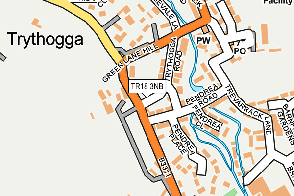
TR18 3NB lies on Trythogga Hill in Gulval, Penzance. TR18 3NB is located in the Ludgvan, Madron, Gulval & Heamoor electoral ward, within the unitary authority of Cornwall and the English Parliamentary constituency of St Ives. The Sub Integrated Care Board (ICB) Location is NHS Cornwall and the Isles of Scilly ICB - 11N and the police force is Devon & Cornwall. This postcode has been in use since January 1980.


GetTheData
Source: OS OpenMap – Local (Ordnance Survey)
Source: OS VectorMap District (Ordnance Survey)
Licence: Open Government Licence (requires attribution)
| Easting | 147814 |
| Northing | 31503 |
| Latitude | 50.129883 |
| Longitude | -5.530007 |
GetTheData
Source: Open Postcode Geo
Licence: Open Government Licence
| Street | Trythogga Hill |
| Locality | Gulval |
| Town/City | Penzance |
| Country | England |
| Postcode District | TR18 |
➜ See where TR18 is on a map ➜ Where is Trevarrack? | |
GetTheData
Source: Land Registry Price Paid Data
Licence: Open Government Licence
Elevation or altitude of TR18 3NB as distance above sea level:
| Metres | Feet | |
|---|---|---|
| Elevation | 20m | 66ft |
Elevation is measured from the approximate centre of the postcode, to the nearest point on an OS contour line from OS Terrain 50, which has contour spacing of ten vertical metres.
➜ How high above sea level am I? Find the elevation of your current position using your device's GPS.
GetTheData
Source: Open Postcode Elevation
Licence: Open Government Licence
| Ward | Ludgvan, Madron, Gulval & Heamoor |
| Constituency | St Ives |
GetTheData
Source: ONS Postcode Database
Licence: Open Government Licence
4, TRYTHOGGA HILL, GULVAL, PENZANCE, TR18 3NB 2021 27 MAY £235,000 |
CHY LANISLEY, TRYTHOGGA HILL, GULVAL, PENZANCE, TR18 3NB 2016 10 JUN £240,000 |
1, TRYTHOGGA HILL, GULVAL, PENZANCE, TR18 3NB 2011 14 OCT £132,500 |
GetTheData
Source: HM Land Registry Price Paid Data
Licence: Contains HM Land Registry data © Crown copyright and database right 2025. This data is licensed under the Open Government Licence v3.0.
| Pendrea Road | Gulval | 56m |
| Pendrea Road | Gulval | 72m |
| Green Lane Hill | Gulval | 152m |
| Green Lane Hill | Gulval | 154m |
| Gulval School (School Lane) | Gulval | 329m |
| Penzance Station | 0.9km |
GetTheData
Source: NaPTAN
Licence: Open Government Licence
| Percentage of properties with Next Generation Access | 100.0% |
| Percentage of properties with Superfast Broadband | 100.0% |
| Percentage of properties with Ultrafast Broadband | 0.0% |
| Percentage of properties with Full Fibre Broadband | 0.0% |
Superfast Broadband is between 30Mbps and 300Mbps
Ultrafast Broadband is > 300Mbps
| Percentage of properties unable to receive 2Mbps | 0.0% |
| Percentage of properties unable to receive 5Mbps | 0.0% |
| Percentage of properties unable to receive 10Mbps | 0.0% |
| Percentage of properties unable to receive 30Mbps | 0.0% |
GetTheData
Source: Ofcom
Licence: Ofcom Terms of Use (requires attribution)
GetTheData
Source: ONS Postcode Database
Licence: Open Government Licence


➜ Get more ratings from the Food Standards Agency
GetTheData
Source: Food Standards Agency
Licence: FSA terms & conditions
| Last Collection | |||
|---|---|---|---|
| Location | Mon-Fri | Sat | Distance |
| Pendrea Road | 17:15 | 11:30 | 85m |
| Gulval Post Office | 17:15 | 11:30 | 198m |
| Chyandour Square | 17:10 | 11:30 | 503m |
GetTheData
Source: Dracos
Licence: Creative Commons Attribution-ShareAlike
The below table lists the International Territorial Level (ITL) codes (formerly Nomenclature of Territorial Units for Statistics (NUTS) codes) and Local Administrative Units (LAU) codes for TR18 3NB:
| ITL 1 Code | Name |
|---|---|
| TLK | South West (England) |
| ITL 2 Code | Name |
| TLK3 | Cornwall and Isles of Scilly |
| ITL 3 Code | Name |
| TLK30 | Cornwall and Isles of Scilly |
| LAU 1 Code | Name |
| E06000052 | Cornwall |
GetTheData
Source: ONS Postcode Directory
Licence: Open Government Licence
The below table lists the Census Output Area (OA), Lower Layer Super Output Area (LSOA), and Middle Layer Super Output Area (MSOA) for TR18 3NB:
| Code | Name | |
|---|---|---|
| OA | E00095855 | |
| LSOA | E01018976 | Cornwall 067A |
| MSOA | E02003948 | Cornwall 067 |
GetTheData
Source: ONS Postcode Directory
Licence: Open Government Licence
| TR18 3LX | Trythogga | 42m |
| TR18 3ND | Pendrea Road | 71m |
| TR18 3NA | Trythogga Road | 84m |
| TR18 3NE | Pendrea Place | 92m |
| TR18 3NG | Trevarrack Place | 106m |
| TR18 3DQ | Trevarrack Lane | 136m |
| TR18 3NF | Pendrea Close | 142m |
| TR18 3LZ | Green Lane Hill | 143m |
| TR18 3DG | Trevarrack Close | 154m |
| TR18 3LY | Trythogga | 157m |
GetTheData
Source: Open Postcode Geo; Land Registry Price Paid Data
Licence: Open Government Licence