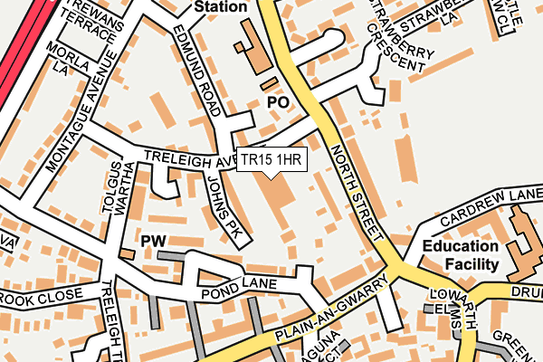
TR15 1HR lies on Bartles Industrial Estate in Redruth. TR15 1HR is located in the Redruth North electoral ward, within the unitary authority of Cornwall and the English Parliamentary constituency of Camborne and Redruth. The Sub Integrated Care Board (ICB) Location is NHS Cornwall and the Isles of Scilly ICB - 11N and the police force is Devon & Cornwall. This postcode has been in use since February 1990.


GetTheData
Source: OS OpenMap – Local (Ordnance Survey)
Source: OS VectorMap District (Ordnance Survey)
Licence: Open Government Licence (requires attribution)
| Easting | 169621 |
| Northing | 42616 |
| Latitude | 50.238539 |
| Longitude | -5.232149 |
GetTheData
Source: Open Postcode Geo
Licence: Open Government Licence
| Street | Bartles Industrial Estate |
| Town/City | Redruth |
| Country | England |
| Postcode District | TR15 |
➜ See where TR15 is on a map ➜ Where is Redruth? | |
GetTheData
Source: Land Registry Price Paid Data
Licence: Open Government Licence
Elevation or altitude of TR15 1HR as distance above sea level:
| Metres | Feet | |
|---|---|---|
| Elevation | 100m | 328ft |
Elevation is measured from the approximate centre of the postcode, to the nearest point on an OS contour line from OS Terrain 50, which has contour spacing of ten vertical metres.
➜ How high above sea level am I? Find the elevation of your current position using your device's GPS.
GetTheData
Source: Open Postcode Elevation
Licence: Open Government Licence
| Ward | Redruth North |
| Constituency | Camborne And Redruth |
GetTheData
Source: ONS Postcode Database
Licence: Open Government Licence
UNIT C, BARTLES INDUSTRIAL ESTATE, REDRUTH, TR15 1HR 2023 12 SEP £4,800,000 |
GetTheData
Source: HM Land Registry Price Paid Data
Licence: Contains HM Land Registry data © Crown copyright and database right 2025. This data is licensed under the Open Government Licence v3.0.
| Ambulance Station (Close Hill) | Redruth | 169m |
| Ambulance Station (Close Hill) | Redruth | 184m |
| Treleigh Terrace | Redruth | 207m |
| Plain-an-gwarry | Redruth | 212m |
| Plain-an-gwarry | Redruth | 223m |
| Redruth Station | 0.7km |
| Camborne Station | 5.6km |
GetTheData
Source: NaPTAN
Licence: Open Government Licence
GetTheData
Source: ONS Postcode Database
Licence: Open Government Licence


➜ Get more ratings from the Food Standards Agency
GetTheData
Source: Food Standards Agency
Licence: FSA terms & conditions
| Last Collection | |||
|---|---|---|---|
| Location | Mon-Fri | Sat | Distance |
| Redruth Post Office | 18:30 | 12:15 | 675m |
| West Trewirgie | 17:45 | 09:00 | 1,059m |
| Albany Road | 17:00 | 10:00 | 1,131m |
GetTheData
Source: Dracos
Licence: Creative Commons Attribution-ShareAlike
The below table lists the International Territorial Level (ITL) codes (formerly Nomenclature of Territorial Units for Statistics (NUTS) codes) and Local Administrative Units (LAU) codes for TR15 1HR:
| ITL 1 Code | Name |
|---|---|
| TLK | South West (England) |
| ITL 2 Code | Name |
| TLK3 | Cornwall and Isles of Scilly |
| ITL 3 Code | Name |
| TLK30 | Cornwall and Isles of Scilly |
| LAU 1 Code | Name |
| E06000052 | Cornwall |
GetTheData
Source: ONS Postcode Directory
Licence: Open Government Licence
The below table lists the Census Output Area (OA), Lower Layer Super Output Area (LSOA), and Middle Layer Super Output Area (MSOA) for TR15 1HR:
| Code | Name | |
|---|---|---|
| OA | E00095493 | |
| LSOA | E01018910 | Cornwall 046C |
| MSOA | E02003919 | Cornwall 046 |
GetTheData
Source: ONS Postcode Directory
Licence: Open Government Licence
| TR15 1DX | Johns Park | 79m |
| TR15 1BD | Pond Lanes End | 87m |
| TR15 1HJ | North Street | 97m |
| TR15 1DL | Chadwick Parc | 106m |
| TR15 1HN | Manor Terrace | 118m |
| TR15 1BQ | Pond Lane | 128m |
| TR15 1AE | Plain An Gwarry | 130m |
| TR15 1DD | Treleigh Avenue | 138m |
| TR15 1HP | Plain An Gwarry | 139m |
| TR15 1EP | Close Hill | 145m |
GetTheData
Source: Open Postcode Geo; Land Registry Price Paid Data
Licence: Open Government Licence