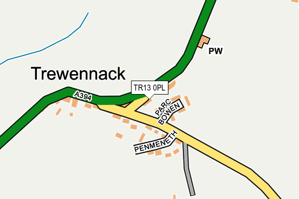
TR13 0PL is in Trewennack, Helston. TR13 0PL is located in the Crowan, Sithney & Wendron electoral ward, within the unitary authority of Cornwall and the English Parliamentary constituency of St Ives. The Sub Integrated Care Board (ICB) Location is NHS Cornwall and the Isles of Scilly ICB - 11N and the police force is Devon & Cornwall. This postcode has been in use since January 1980.


GetTheData
Source: OS OpenMap – Local (Ordnance Survey)
Source: OS VectorMap District (Ordnance Survey)
Licence: Open Government Licence (requires attribution)
| Easting | 168001 |
| Northing | 28721 |
| Latitude | 50.113130 |
| Longitude | -5.246405 |
GetTheData
Source: Open Postcode Geo
Licence: Open Government Licence
| Locality | Trewennack |
| Town/City | Helston |
| Country | England |
| Postcode District | TR13 |
➜ See where TR13 is on a map ➜ Where is Trewennack? | |
GetTheData
Source: Land Registry Price Paid Data
Licence: Open Government Licence
Elevation or altitude of TR13 0PL as distance above sea level:
| Metres | Feet | |
|---|---|---|
| Elevation | 80m | 262ft |
Elevation is measured from the approximate centre of the postcode, to the nearest point on an OS contour line from OS Terrain 50, which has contour spacing of ten vertical metres.
➜ How high above sea level am I? Find the elevation of your current position using your device's GPS.
GetTheData
Source: Open Postcode Elevation
Licence: Open Government Licence
| Ward | Crowan, Sithney & Wendron |
| Constituency | St Ives |
GetTheData
Source: ONS Postcode Database
Licence: Open Government Licence
| Bus Shelter (A394) | Trewennack | 181m |
| Bus Shelter (A394) | Trewennack | 208m |
| Tremenhere House | Trewennack | 500m |
| Tremenhere House | Trewennack | 515m |
| Manor Close (Tremenheere Avenue) | Helston | 1,154m |
GetTheData
Source: NaPTAN
Licence: Open Government Licence
| Percentage of properties with Next Generation Access | 100.0% |
| Percentage of properties with Superfast Broadband | 100.0% |
| Percentage of properties with Ultrafast Broadband | 100.0% |
| Percentage of properties with Full Fibre Broadband | 100.0% |
Superfast Broadband is between 30Mbps and 300Mbps
Ultrafast Broadband is > 300Mbps
| Percentage of properties unable to receive 2Mbps | 0.0% |
| Percentage of properties unable to receive 5Mbps | 0.0% |
| Percentage of properties unable to receive 10Mbps | 0.0% |
| Percentage of properties unable to receive 30Mbps | 0.0% |
GetTheData
Source: Ofcom
Licence: Ofcom Terms of Use (requires attribution)
GetTheData
Source: ONS Postcode Database
Licence: Open Government Licence


➜ Get more ratings from the Food Standards Agency
GetTheData
Source: Food Standards Agency
Licence: FSA terms & conditions
| Last Collection | |||
|---|---|---|---|
| Location | Mon-Fri | Sat | Distance |
| Tesco (Clodgey Lane) | 17:15 | 11:00 | 1,652m |
| Water Ma Trout | 17:20 | 09:00 | 1,755m |
| Church Hill | 17:15 | 11:00 | 2,236m |
GetTheData
Source: Dracos
Licence: Creative Commons Attribution-ShareAlike
The below table lists the International Territorial Level (ITL) codes (formerly Nomenclature of Territorial Units for Statistics (NUTS) codes) and Local Administrative Units (LAU) codes for TR13 0PL:
| ITL 1 Code | Name |
|---|---|
| TLK | South West (England) |
| ITL 2 Code | Name |
| TLK3 | Cornwall and Isles of Scilly |
| ITL 3 Code | Name |
| TLK30 | Cornwall and Isles of Scilly |
| LAU 1 Code | Name |
| E06000052 | Cornwall |
GetTheData
Source: ONS Postcode Directory
Licence: Open Government Licence
The below table lists the Census Output Area (OA), Lower Layer Super Output Area (LSOA), and Middle Layer Super Output Area (MSOA) for TR13 0PL:
| Code | Name | |
|---|---|---|
| OA | E00095363 | |
| LSOA | E01018883 | Cornwall 071B |
| MSOA | E02003928 | Cornwall 071 |
GetTheData
Source: ONS Postcode Directory
Licence: Open Government Licence
| TR13 0PJ | Parc Bowen | 26m |
| TR13 0PH | 101m | |
| TR13 0PU | Penmeneth | 116m |
| TR13 0PQ | 198m | |
| TR13 0PW | 496m | |
| TR13 0PG | 545m | |
| TR13 0PN | 594m | |
| TR13 0PP | 925m | |
| TR13 0NG | 997m | |
| TR13 0NQ | 1007m |
GetTheData
Source: Open Postcode Geo; Land Registry Price Paid Data
Licence: Open Government Licence