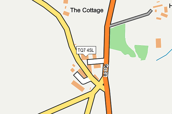
TQ7 4SL lies on The Butts in Loddiswell, Kingsbridge. TQ7 4SL is located in the Loddiswell & Aveton Gifford electoral ward, within the local authority district of South Hams and the English Parliamentary constituency of Totnes. The Sub Integrated Care Board (ICB) Location is NHS Devon ICB - 15N and the police force is Devon & Cornwall. This postcode has been in use since May 1994.


GetTheData
Source: OS OpenMap – Local (Ordnance Survey)
Source: OS VectorMap District (Ordnance Survey)
Licence: Open Government Licence (requires attribution)
| Easting | 271843 |
| Northing | 49111 |
| Latitude | 50.327938 |
| Longitude | -3.801881 |
GetTheData
Source: Open Postcode Geo
Licence: Open Government Licence
| Street | The Butts |
| Locality | Loddiswell |
| Town/City | Kingsbridge |
| Country | England |
| Postcode District | TQ7 |
➜ See where TQ7 is on a map | |
GetTheData
Source: Land Registry Price Paid Data
Licence: Open Government Licence
Elevation or altitude of TQ7 4SL as distance above sea level:
| Metres | Feet | |
|---|---|---|
| Elevation | 100m | 328ft |
Elevation is measured from the approximate centre of the postcode, to the nearest point on an OS contour line from OS Terrain 50, which has contour spacing of ten vertical metres.
➜ How high above sea level am I? Find the elevation of your current position using your device's GPS.
GetTheData
Source: Open Postcode Elevation
Licence: Open Government Licence
| Ward | Loddiswell & Aveton Gifford |
| Constituency | Totnes |
GetTheData
Source: ONS Postcode Database
Licence: Open Government Licence
| Loddiswell Inn (Fore Street) | Loddiswell | 594m |
| Loddiswell Inn (Fore Street) | Loddiswell | 601m |
GetTheData
Source: NaPTAN
Licence: Open Government Licence
GetTheData
Source: ONS Postcode Database
Licence: Open Government Licence


➜ Get more ratings from the Food Standards Agency
GetTheData
Source: Food Standards Agency
Licence: FSA terms & conditions
| Last Collection | |||
|---|---|---|---|
| Location | Mon-Fri | Sat | Distance |
| Ledstone | 17:00 | 09:15 | 3,871m |
| Gara Bridge | 16:35 | 08:00 | 4,503m |
| Police Station | 17:30 | 12:00 | 4,722m |
GetTheData
Source: Dracos
Licence: Creative Commons Attribution-ShareAlike
The below table lists the International Territorial Level (ITL) codes (formerly Nomenclature of Territorial Units for Statistics (NUTS) codes) and Local Administrative Units (LAU) codes for TQ7 4SL:
| ITL 1 Code | Name |
|---|---|
| TLK | South West (England) |
| ITL 2 Code | Name |
| TLK4 | Devon |
| ITL 3 Code | Name |
| TLK43 | Devon CC |
| LAU 1 Code | Name |
| E07000044 | South Hams |
GetTheData
Source: ONS Postcode Directory
Licence: Open Government Licence
The below table lists the Census Output Area (OA), Lower Layer Super Output Area (LSOA), and Middle Layer Super Output Area (MSOA) for TQ7 4SL:
| Code | Name | |
|---|---|---|
| OA | E00101999 | |
| LSOA | E01020142 | South Hams 006A |
| MSOA | E02004194 | South Hams 006 |
GetTheData
Source: ONS Postcode Directory
Licence: Open Government Licence
| TQ7 4RU | Robins Park | 48m |
| TQ7 4RX | 318m | |
| TQ7 4BY | Beechwood Park | 355m |
| TQ7 4BU | Harveys Walk | 432m |
| TQ7 4RH | The Terrace | 445m |
| TQ7 4SA | Elmwood Park | 454m |
| TQ7 4RL | 468m | |
| TQ7 4SH | School House Gardens | 477m |
| TQ7 4BT | Chestnut Way | 477m |
| TQ7 4RW | 533m |
GetTheData
Source: Open Postcode Geo; Land Registry Price Paid Data
Licence: Open Government Licence