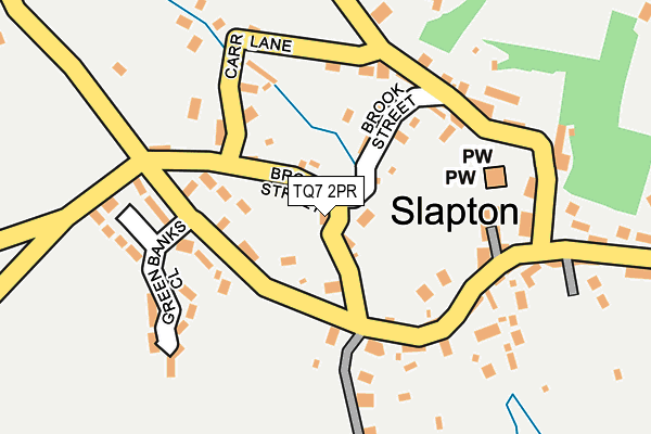
TQ7 2PR is in Slapton, Kingsbridge. TQ7 2PR is located in the Allington & Strete electoral ward, within the local authority district of South Hams and the English Parliamentary constituency of Totnes. The Sub Integrated Care Board (ICB) Location is NHS Devon ICB - 15N and the police force is Devon & Cornwall. This postcode has been in use since January 1980.


GetTheData
Source: OS OpenMap – Local (Ordnance Survey)
Source: OS VectorMap District (Ordnance Survey)
Licence: Open Government Licence (requires attribution)
| Easting | 281975 |
| Northing | 44953 |
| Latitude | 50.292695 |
| Longitude | -3.658276 |
GetTheData
Source: Open Postcode Geo
Licence: Open Government Licence
| Locality | Slapton |
| Town/City | Kingsbridge |
| Country | England |
| Postcode District | TQ7 |
➜ See where TQ7 is on a map ➜ Where is Slapton? | |
GetTheData
Source: Land Registry Price Paid Data
Licence: Open Government Licence
Elevation or altitude of TQ7 2PR as distance above sea level:
| Metres | Feet | |
|---|---|---|
| Elevation | 30m | 98ft |
Elevation is measured from the approximate centre of the postcode, to the nearest point on an OS contour line from OS Terrain 50, which has contour spacing of ten vertical metres.
➜ How high above sea level am I? Find the elevation of your current position using your device's GPS.
GetTheData
Source: Open Postcode Elevation
Licence: Open Government Licence
| Ward | Allington & Strete |
| Constituency | Totnes |
GetTheData
Source: ONS Postcode Database
Licence: Open Government Licence
SWALLOW COTTAGE, SLAPTON, KINGSBRIDGE, TQ7 2PR 2022 19 JUL £215,000 |
2022 16 MAY £1,500,000 |
CHURCH VIEW, SLAPTON, KINGSBRIDGE, TQ7 2PR 2012 22 JUN £450,000 |
SLOUTTS FARM, SLAPTON, KINGSBRIDGE, TQ7 2PR 2009 25 SEP £840,000 |
SWALLOW COTTAGE, SLAPTON, KINGSBRIDGE, TQ7 2PR 2009 23 JAN £132,500 |
MEADOWSIDE COTTAGE, SLAPTON, KINGSBRIDGE, TQ7 2PR 2005 25 AUG £330,000 |
2002 1 MAY £490,000 |
SUNWAYS, SLAPTON, KINGSBRIDGE, TQ7 2PR 1996 24 OCT £156,000 |
GetTheData
Source: HM Land Registry Price Paid Data
Licence: Contains HM Land Registry data © Crown copyright and database right 2025. This data is licensed under the Open Government Licence v3.0.
| Slapton Village (Sands Road) | Slapton | 354m |
| Slapton Turn (A379) | Slapton | 1,108m |
| Slapton Turn (A379) | Slapton | 1,116m |
| Strete Gate (A379) | Slapton | 1,575m |
| Strete Gate (A379) | Slapton | 1,585m |
GetTheData
Source: NaPTAN
Licence: Open Government Licence
| Percentage of properties with Next Generation Access | 100.0% |
| Percentage of properties with Superfast Broadband | 100.0% |
| Percentage of properties with Ultrafast Broadband | 0.0% |
| Percentage of properties with Full Fibre Broadband | 0.0% |
Superfast Broadband is between 30Mbps and 300Mbps
Ultrafast Broadband is > 300Mbps
| Median download speed | 35.0Mbps |
| Average download speed | 24.9Mbps |
| Maximum download speed | 45.61Mbps |
| Median upload speed | 7.6Mbps |
| Average upload speed | 5.7Mbps |
| Maximum upload speed | 10.00Mbps |
| Percentage of properties unable to receive 2Mbps | 0.0% |
| Percentage of properties unable to receive 5Mbps | 0.0% |
| Percentage of properties unable to receive 10Mbps | 0.0% |
| Percentage of properties unable to receive 30Mbps | 0.0% |
GetTheData
Source: Ofcom
Licence: Ofcom Terms of Use (requires attribution)
GetTheData
Source: ONS Postcode Database
Licence: Open Government Licence


➜ Get more ratings from the Food Standards Agency
GetTheData
Source: Food Standards Agency
Licence: FSA terms & conditions
| Last Collection | |||
|---|---|---|---|
| Location | Mon-Fri | Sat | Distance |
| Slapton Post Office | 16:15 | 10:30 | 279m |
| Old Stokenham Post Office | 16:30 | 11:45 | 2,423m |
| Torcross Post Office | 16:00 | 10:45 | 2,953m |
GetTheData
Source: Dracos
Licence: Creative Commons Attribution-ShareAlike
The below table lists the International Territorial Level (ITL) codes (formerly Nomenclature of Territorial Units for Statistics (NUTS) codes) and Local Administrative Units (LAU) codes for TQ7 2PR:
| ITL 1 Code | Name |
|---|---|
| TLK | South West (England) |
| ITL 2 Code | Name |
| TLK4 | Devon |
| ITL 3 Code | Name |
| TLK43 | Devon CC |
| LAU 1 Code | Name |
| E07000044 | South Hams |
GetTheData
Source: ONS Postcode Directory
Licence: Open Government Licence
The below table lists the Census Output Area (OA), Lower Layer Super Output Area (LSOA), and Middle Layer Super Output Area (MSOA) for TQ7 2PR:
| Code | Name | |
|---|---|---|
| OA | E00102183 | |
| LSOA | E01020175 | South Hams 011B |
| MSOA | E02004199 | South Hams 011 |
GetTheData
Source: ONS Postcode Directory
Licence: Open Government Licence
| TQ7 2PW | Brook Street | 97m |
| TQ7 2QA | Brandis Park | 100m |
| TQ7 2PP | South View Terrace | 100m |
| TQ7 2PU | Carr Lane | 117m |
| TQ7 2PY | 137m | |
| TQ7 2QU | Vale Cottages | 138m |
| TQ7 2PS | Prospect Hill | 145m |
| TQ7 2QT | 147m | |
| TQ7 2QS | Church Lane | 147m |
| TQ7 2QR | Church Wells | 148m |
GetTheData
Source: Open Postcode Geo; Land Registry Price Paid Data
Licence: Open Government Licence