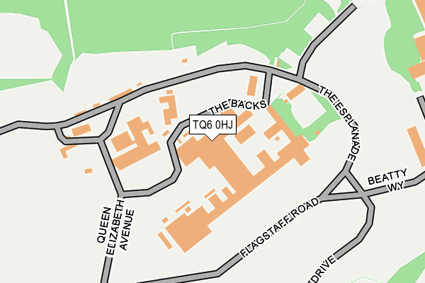
TQ6 0HJ is located in the Dartmouth & East Dart electoral ward, within the local authority district of South Hams and the English Parliamentary constituency of Totnes. The Sub Integrated Care Board (ICB) Location is NHS Devon ICB - 15N and the police force is Devon & Cornwall. This postcode has been in use since January 1980.


GetTheData
Source: OS OpenMap – Local (Ordnance Survey)
Source: OS VectorMap District (Ordnance Survey)
Licence: Open Government Licence (requires attribution)
| Easting | 287488 |
| Northing | 52053 |
| Latitude | 50.357601 |
| Longitude | -3.583032 |
GetTheData
Source: Open Postcode Geo
Licence: Open Government Licence
| Country | England |
| Postcode District | TQ6 |
➜ See where TQ6 is on a map ➜ Where is Dartmouth? | |
GetTheData
Source: Land Registry Price Paid Data
Licence: Open Government Licence
Elevation or altitude of TQ6 0HJ as distance above sea level:
| Metres | Feet | |
|---|---|---|
| Elevation | 70m | 230ft |
Elevation is measured from the approximate centre of the postcode, to the nearest point on an OS contour line from OS Terrain 50, which has contour spacing of ten vertical metres.
➜ How high above sea level am I? Find the elevation of your current position using your device's GPS.
GetTheData
Source: Open Postcode Elevation
Licence: Open Government Licence
| Ward | Dartmouth & East Dart |
| Constituency | Totnes |
GetTheData
Source: ONS Postcode Database
Licence: Open Government Licence
| M&s Simply Food (Mayor's Avenue) | Dartmouth | 614m |
| Beechfield Terrace (Townstal Road) | Townstal | 665m |
| College Way | Dartmouth | 674m |
| Beechfield Terrace (Townstal Road) | Townstal | 675m |
| Seale Arms (Victoria Road) | Dartmouth | 713m |
| Kingswear (Paignton And Dartmouth Railway) (Fore Street) | Kingswear | 1,216m |
GetTheData
Source: NaPTAN
Licence: Open Government Licence
| Percentage of properties with Next Generation Access | 100.0% |
| Percentage of properties with Superfast Broadband | 100.0% |
| Percentage of properties with Ultrafast Broadband | 0.0% |
| Percentage of properties with Full Fibre Broadband | 0.0% |
Superfast Broadband is between 30Mbps and 300Mbps
Ultrafast Broadband is > 300Mbps
| Percentage of properties unable to receive 2Mbps | 0.0% |
| Percentage of properties unable to receive 5Mbps | 0.0% |
| Percentage of properties unable to receive 10Mbps | 0.0% |
| Percentage of properties unable to receive 30Mbps | 0.0% |
GetTheData
Source: Ofcom
Licence: Ofcom Terms of Use (requires attribution)
GetTheData
Source: ONS Postcode Database
Licence: Open Government Licence


➜ Get more ratings from the Food Standards Agency
GetTheData
Source: Food Standards Agency
Licence: FSA terms & conditions
| Last Collection | |||
|---|---|---|---|
| Location | Mon-Fri | Sat | Distance |
| Sand Quay | 17:30 | 12:00 | 420m |
| Dartmouth Post Office | 17:30 | 12:00 | 612m |
| Church Close | 17:15 | 11:45 | 830m |
GetTheData
Source: Dracos
Licence: Creative Commons Attribution-ShareAlike
The below table lists the International Territorial Level (ITL) codes (formerly Nomenclature of Territorial Units for Statistics (NUTS) codes) and Local Administrative Units (LAU) codes for TQ6 0HJ:
| ITL 1 Code | Name |
|---|---|
| TLK | South West (England) |
| ITL 2 Code | Name |
| TLK4 | Devon |
| ITL 3 Code | Name |
| TLK43 | Devon CC |
| LAU 1 Code | Name |
| E07000044 | South Hams |
GetTheData
Source: ONS Postcode Directory
Licence: Open Government Licence
The below table lists the Census Output Area (OA), Lower Layer Super Output Area (LSOA), and Middle Layer Super Output Area (MSOA) for TQ6 0HJ:
| Code | Name | |
|---|---|---|
| OA | E00102065 | |
| LSOA | E01020154 | South Hams 007C |
| MSOA | E02004195 | South Hams 007 |
GetTheData
Source: ONS Postcode Directory
Licence: Open Government Licence
| TQ6 9PH | Sandquay Road | 354m |
| TQ6 9PQ | Coombe Road | 368m |
| TQ6 9QP | Sandquay Road | 390m |
| TQ6 9PF | College Way | 433m |
| TQ6 9PE | Ridge Hill | 483m |
| TQ6 9PB | Mount Boone | 496m |
| TQ6 9PR | Redwalls Meadow | 506m |
| TQ6 9PD | Coombe Close | 509m |
| TQ6 9NZ | Mount Boone Hill | 518m |
| TQ6 9NP | Clarence Street | 535m |
GetTheData
Source: Open Postcode Geo; Land Registry Price Paid Data
Licence: Open Government Licence