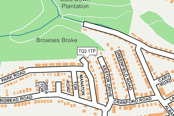
TQ3 1TP lies on Oke Tor Close in Paignton. TQ3 1TP is located in the Preston electoral ward, within the unitary authority of Torbay and the English Parliamentary constituency of Torbay. The Sub Integrated Care Board (ICB) Location is NHS Devon ICB - 15N and the police force is Devon & Cornwall. This postcode has been in use since January 1983.


GetTheData
Source: OS OpenMap – Local (Ordnance Survey)
Source: OS VectorMap District (Ordnance Survey)
Licence: Open Government Licence (requires attribution)
| Easting | 288016 |
| Northing | 62537 |
| Latitude | 50.451950 |
| Longitude | -3.578742 |
GetTheData
Source: Open Postcode Geo
Licence: Open Government Licence
| Street | Oke Tor Close |
| Town/City | Paignton |
| Country | England |
| Postcode District | TQ3 |
➜ See where TQ3 is on a map ➜ Where is Paignton? | |
GetTheData
Source: Land Registry Price Paid Data
Licence: Open Government Licence
Elevation or altitude of TQ3 1TP as distance above sea level:
| Metres | Feet | |
|---|---|---|
| Elevation | 110m | 361ft |
Elevation is measured from the approximate centre of the postcode, to the nearest point on an OS contour line from OS Terrain 50, which has contour spacing of ten vertical metres.
➜ How high above sea level am I? Find the elevation of your current position using your device's GPS.
GetTheData
Source: Open Postcode Elevation
Licence: Open Government Licence
| Ward | Preston |
| Constituency | Torbay |
GetTheData
Source: ONS Postcode Database
Licence: Open Government Licence
2022 23 JUN £515,000 |
2016 22 DEC £200,000 |
2015 16 MAR £177,500 |
2013 22 MAR £250,000 |
4, OKE TOR CLOSE, PAIGNTON, TQ3 1TP 2010 8 OCT £264,000 |
2005 20 MAY £249,950 |
1995 28 JUL £65,000 |
GetTheData
Source: HM Land Registry Price Paid Data
Licence: Contains HM Land Registry data © Crown copyright and database right 2025. This data is licensed under the Open Government Licence v3.0.
| Manaton Tor Road (Longmead Road) | Preston | 147m |
| Cranford Road | Preston | 198m |
| 147 Occombe Valley Road (Occaombe Valley Road) | Preston | 209m |
| 126 Occombe Valley Road (Occaombe Valley Road) | Preston | 238m |
| Dolphin Court | Preston | 253m |
| Paignton Station | 2.2km |
| Torquay Station | 2.7km |
| Torre Station | 3.3km |
GetTheData
Source: NaPTAN
Licence: Open Government Licence
| Percentage of properties with Next Generation Access | 100.0% |
| Percentage of properties with Superfast Broadband | 80.0% |
| Percentage of properties with Ultrafast Broadband | 80.0% |
| Percentage of properties with Full Fibre Broadband | 0.0% |
Superfast Broadband is between 30Mbps and 300Mbps
Ultrafast Broadband is > 300Mbps
| Percentage of properties unable to receive 2Mbps | 0.0% |
| Percentage of properties unable to receive 5Mbps | 0.0% |
| Percentage of properties unable to receive 10Mbps | 0.0% |
| Percentage of properties unable to receive 30Mbps | 20.0% |
GetTheData
Source: Ofcom
Licence: Ofcom Terms of Use (requires attribution)
GetTheData
Source: ONS Postcode Database
Licence: Open Government Licence


➜ Get more ratings from the Food Standards Agency
GetTheData
Source: Food Standards Agency
Licence: FSA terms & conditions
| Last Collection | |||
|---|---|---|---|
| Location | Mon-Fri | Sat | Distance |
| Windmill Road | 17:45 | 12:30 | 255m |
| Templar Road | 17:00 | 12:00 | 503m |
| Occombe Valley | 17:30 | 12:30 | 506m |
GetTheData
Source: Dracos
Licence: Creative Commons Attribution-ShareAlike
The below table lists the International Territorial Level (ITL) codes (formerly Nomenclature of Territorial Units for Statistics (NUTS) codes) and Local Administrative Units (LAU) codes for TQ3 1TP:
| ITL 1 Code | Name |
|---|---|
| TLK | South West (England) |
| ITL 2 Code | Name |
| TLK4 | Devon |
| ITL 3 Code | Name |
| TLK42 | Torbay |
| LAU 1 Code | Name |
| E06000027 | Torbay |
GetTheData
Source: ONS Postcode Directory
Licence: Open Government Licence
The below table lists the Census Output Area (OA), Lower Layer Super Output Area (LSOA), and Middle Layer Super Output Area (MSOA) for TQ3 1TP:
| Code | Name | |
|---|---|---|
| OA | E00076942 | |
| LSOA | E01015226 | Torbay 011C |
| MSOA | E02003164 | Torbay 011 |
GetTheData
Source: ONS Postcode Directory
Licence: Open Government Licence
| TQ3 1AP | Kestor Drive | 85m |
| TQ3 1AH | Green Park Road | 101m |
| TQ3 1AL | Manaton Tor Road | 103m |
| TQ3 1QR | Occombe Valley Road | 106m |
| TQ3 1DB | Greenfield Road | 117m |
| TQ3 1AR | Sharpitor Close | 130m |
| TQ3 1AJ | Green Park Road | 161m |
| TQ3 1AS | Grea Tor Close | 172m |
| TQ3 1BZ | Albany Road | 186m |
| TQ3 1AW | Longmead Road | 203m |
GetTheData
Source: Open Postcode Geo; Land Registry Price Paid Data
Licence: Open Government Licence