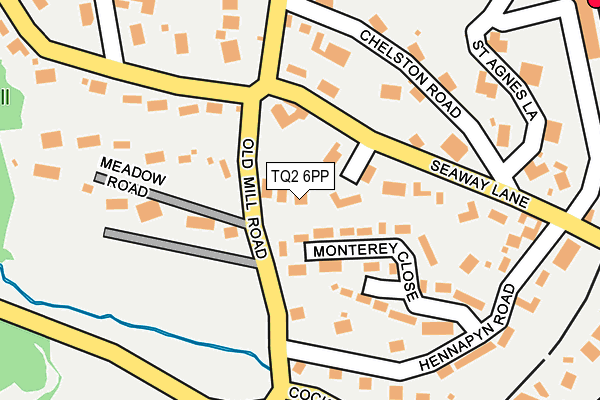
TQ2 6PP lies on Old Mill Road in Torquay. TQ2 6PP is located in the Cockington with Chelston electoral ward, within the unitary authority of Torbay and the English Parliamentary constituency of Torbay. The Sub Integrated Care Board (ICB) Location is NHS Devon ICB - 15N and the police force is Devon & Cornwall. This postcode has been in use since January 1980.


GetTheData
Source: OS OpenMap – Local (Ordnance Survey)
Source: OS VectorMap District (Ordnance Survey)
Licence: Open Government Licence (requires attribution)
| Easting | 290256 |
| Northing | 63316 |
| Latitude | 50.459363 |
| Longitude | -3.547446 |
GetTheData
Source: Open Postcode Geo
Licence: Open Government Licence
| Street | Old Mill Road |
| Town/City | Torquay |
| Country | England |
| Postcode District | TQ2 |
➜ See where TQ2 is on a map ➜ Where is Paignton? | |
GetTheData
Source: Land Registry Price Paid Data
Licence: Open Government Licence
Elevation or altitude of TQ2 6PP as distance above sea level:
| Metres | Feet | |
|---|---|---|
| Elevation | 40m | 131ft |
Elevation is measured from the approximate centre of the postcode, to the nearest point on an OS contour line from OS Terrain 50, which has contour spacing of ten vertical metres.
➜ How high above sea level am I? Find the elevation of your current position using your device's GPS.
GetTheData
Source: Open Postcode Elevation
Licence: Open Government Licence
| Ward | Cockington With Chelston |
| Constituency | Torbay |
GetTheData
Source: ONS Postcode Database
Licence: Open Government Licence
MIRAMAR, OLD MILL ROAD, TORQUAY, TQ2 6PP 2022 21 OCT £1,499,000 |
TALL TREES, OLD MILL ROAD, TORQUAY, TQ2 6PP 2014 30 SEP £765,000 |
NOOSA HEADS, OLD MILL ROAD, TORQUAY, TQ2 6PP 2011 22 JUN £454,000 |
TRANBY CLOSE, OLD MILL ROAD, TORQUAY, TQ2 6PP 2010 23 DEC £445,000 |
GetTheData
Source: HM Land Registry Price Paid Data
Licence: Contains HM Land Registry data © Crown copyright and database right 2025. This data is licensed under the Open Government Licence v3.0.
| Chelston Road | Chelston | 168m |
| Hennapyn Road | Torquay | 228m |
| Hennapyn Road | Torquay | 251m |
| Rawlyn Road | Chelston | 284m |
| Underhill (Underhill Road) | Livermead | 338m |
| Torquay Station | 0.4km |
| Torre Station | 1.5km |
| Paignton Station | 3km |
GetTheData
Source: NaPTAN
Licence: Open Government Licence
| Percentage of properties with Next Generation Access | 50.0% |
| Percentage of properties with Superfast Broadband | 50.0% |
| Percentage of properties with Ultrafast Broadband | 50.0% |
| Percentage of properties with Full Fibre Broadband | 0.0% |
Superfast Broadband is between 30Mbps and 300Mbps
Ultrafast Broadband is > 300Mbps
| Percentage of properties unable to receive 2Mbps | 0.0% |
| Percentage of properties unable to receive 5Mbps | 0.0% |
| Percentage of properties unable to receive 10Mbps | 0.0% |
| Percentage of properties unable to receive 30Mbps | 50.0% |
GetTheData
Source: Ofcom
Licence: Ofcom Terms of Use (requires attribution)
GetTheData
Source: ONS Postcode Database
Licence: Open Government Licence


➜ Get more ratings from the Food Standards Agency
GetTheData
Source: Food Standards Agency
Licence: FSA terms & conditions
| Last Collection | |||
|---|---|---|---|
| Location | Mon-Fri | Sat | Distance |
| Meadow Road | 17:30 | 12:30 | 61m |
| Chelston Post Office | 18:00 | 12:00 | 375m |
| Recreation Ground | 17:30 | 12:15 | 468m |
GetTheData
Source: Dracos
Licence: Creative Commons Attribution-ShareAlike
The below table lists the International Territorial Level (ITL) codes (formerly Nomenclature of Territorial Units for Statistics (NUTS) codes) and Local Administrative Units (LAU) codes for TQ2 6PP:
| ITL 1 Code | Name |
|---|---|
| TLK | South West (England) |
| ITL 2 Code | Name |
| TLK4 | Devon |
| ITL 3 Code | Name |
| TLK42 | Torbay |
| LAU 1 Code | Name |
| E06000027 | Torbay |
GetTheData
Source: ONS Postcode Directory
Licence: Open Government Licence
The below table lists the Census Output Area (OA), Lower Layer Super Output Area (LSOA), and Middle Layer Super Output Area (MSOA) for TQ2 6PP:
| Code | Name | |
|---|---|---|
| OA | E00076855 | |
| LSOA | E01015208 | Torbay 019F |
| MSOA | E02006840 | Torbay 019 |
GetTheData
Source: ONS Postcode Directory
Licence: Open Government Licence
| TQ2 6PY | Seaway Close | 57m |
| TQ2 6PS | Seaway Lane | 87m |
| TQ2 6QW | Monterey Close | 114m |
| TQ2 6PX | Chelston Road | 152m |
| TQ2 6PR | Meadow Road | 153m |
| TQ2 6QR | Hennapyn Road | 175m |
| TQ2 6PU | Chelston Road | 188m |
| TQ2 6PG | Old Mill Road | 193m |
| TQ2 6QS | Cockington Lane | 195m |
| TQ2 6QF | Seaway Lane | 228m |
GetTheData
Source: Open Postcode Geo; Land Registry Price Paid Data
Licence: Open Government Licence