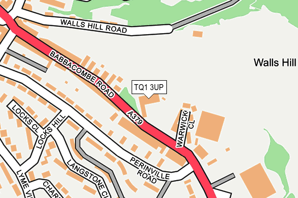
TQ1 3UP is located in the St Marychurch electoral ward, within the unitary authority of Torbay and the English Parliamentary constituency of Torbay. The Sub Integrated Care Board (ICB) Location is NHS Devon ICB - 15N and the police force is Devon & Cornwall. This postcode has been in use since February 2005.


GetTheData
Source: OS OpenMap – Local (Ordnance Survey)
Source: OS VectorMap District (Ordnance Survey)
Licence: Open Government Licence (requires attribution)
| Easting | 293023 |
| Northing | 65113 |
| Latitude | 50.476030 |
| Longitude | -3.508992 |
GetTheData
Source: Open Postcode Geo
Licence: Open Government Licence
| Country | England |
| Postcode District | TQ1 |
➜ See where TQ1 is on a map ➜ Where is Torquay? | |
GetTheData
Source: Land Registry Price Paid Data
Licence: Open Government Licence
Elevation or altitude of TQ1 3UP as distance above sea level:
| Metres | Feet | |
|---|---|---|
| Elevation | 80m | 262ft |
Elevation is measured from the approximate centre of the postcode, to the nearest point on an OS contour line from OS Terrain 50, which has contour spacing of ten vertical metres.
➜ How high above sea level am I? Find the elevation of your current position using your device's GPS.
GetTheData
Source: Open Postcode Elevation
Licence: Open Government Licence
| Ward | St Marychurch |
| Constituency | Torbay |
GetTheData
Source: ONS Postcode Database
Licence: Open Government Licence
| Pottery (Babbacombe Road) | Babbacombe | 54m |
| Babbacombe Rd 142 (Babbacombe Road) | Babbacombe | 124m |
| Locks Hill | Babbacombe | 189m |
| Locks Hill | Babbacombe | 236m |
| Lyme View Road | Babbacombe | 300m |
| Torre Station | 2.7km |
| Torquay Station | 2.9km |
| Paignton Station | 6.1km |
GetTheData
Source: NaPTAN
Licence: Open Government Licence
GetTheData
Source: ONS Postcode Database
Licence: Open Government Licence


➜ Get more ratings from the Food Standards Agency
GetTheData
Source: Food Standards Agency
Licence: FSA terms & conditions
| Last Collection | |||
|---|---|---|---|
| Location | Mon-Fri | Sat | Distance |
| Lyme View Road | 17:45 | 12:30 | 292m |
| Quinta Road | 17:45 | 12:45 | 625m |
| Cary Park | 17:30 | 12:45 | 848m |
GetTheData
Source: Dracos
Licence: Creative Commons Attribution-ShareAlike
The below table lists the International Territorial Level (ITL) codes (formerly Nomenclature of Territorial Units for Statistics (NUTS) codes) and Local Administrative Units (LAU) codes for TQ1 3UP:
| ITL 1 Code | Name |
|---|---|
| TLK | South West (England) |
| ITL 2 Code | Name |
| TLK4 | Devon |
| ITL 3 Code | Name |
| TLK42 | Torbay |
| LAU 1 Code | Name |
| E06000027 | Torbay |
GetTheData
Source: ONS Postcode Directory
Licence: Open Government Licence
The below table lists the Census Output Area (OA), Lower Layer Super Output Area (LSOA), and Middle Layer Super Output Area (MSOA) for TQ1 3UP:
| Code | Name | |
|---|---|---|
| OA | E00077000 | |
| LSOA | E01015240 | Torbay 005A |
| MSOA | E02003158 | Torbay 005 |
GetTheData
Source: ONS Postcode Directory
Licence: Open Government Licence
| TQ1 3SZ | Babbacombe Road | 87m |
| TQ1 3PD | Perinville Road | 96m |
| TQ1 3TH | Warwick Close | 98m |
| TQ1 3SX | Babbacombe Road | 109m |
| TQ1 3PB | Perinville Road | 142m |
| TQ1 3TY | Langstone Close | 173m |
| TQ1 3SY | Babbacombe Road | 181m |
| TQ1 3TX | Langstone Close | 216m |
| TQ1 3TT | Locks Hill | 223m |
| TQ1 3LZ | Walls Hill Road | 224m |
GetTheData
Source: Open Postcode Geo; Land Registry Price Paid Data
Licence: Open Government Licence