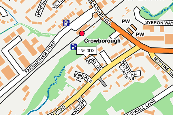
TN6 3DX lies on Dairy Green in Crowborough. TN6 3DX is located in the Crowborough Jarvis Brook electoral ward, within the local authority district of Wealden and the English Parliamentary constituency of Wealden. The Sub Integrated Care Board (ICB) Location is NHS Sussex ICB - 97R and the police force is Sussex. This postcode has been in use since December 1996.


GetTheData
Source: OS OpenMap – Local (Ordnance Survey)
Source: OS VectorMap District (Ordnance Survey)
Licence: Open Government Licence (requires attribution)
| Easting | 553487 |
| Northing | 129624 |
| Latitude | 51.045468 |
| Longitude | 0.188183 |
GetTheData
Source: Open Postcode Geo
Licence: Open Government Licence
| Street | Dairy Green |
| Town/City | Crowborough |
| Country | England |
| Postcode District | TN6 |
➜ See where TN6 is on a map ➜ Where is Crowborough? | |
GetTheData
Source: Land Registry Price Paid Data
Licence: Open Government Licence
Elevation or altitude of TN6 3DX as distance above sea level:
| Metres | Feet | |
|---|---|---|
| Elevation | 110m | 361ft |
Elevation is measured from the approximate centre of the postcode, to the nearest point on an OS contour line from OS Terrain 50, which has contour spacing of ten vertical metres.
➜ How high above sea level am I? Find the elevation of your current position using your device's GPS.
GetTheData
Source: Open Postcode Elevation
Licence: Open Government Licence
| Ward | Crowborough Jarvis Brook |
| Constituency | Wealden |
GetTheData
Source: ONS Postcode Database
Licence: Open Government Licence
| Crowborough Railway Station (Farningham Road) | Jarvis Brook | 103m |
| Knowle Close (Western Road) | Jarvis Brook | 116m |
| Knowle Close (Western Road) | Jarvis Brook | 139m |
| Crowborough Railway Station (Crowborough Hill) | Jarvis Brook | 172m |
| Crowborough Railway Station (Crowborough Hill) | Jarvis Brook | 198m |
| Crowborough Station | 0.1km |
| Eridge Station | 4.9km |
GetTheData
Source: NaPTAN
Licence: Open Government Licence
| Percentage of properties with Next Generation Access | 100.0% |
| Percentage of properties with Superfast Broadband | 100.0% |
| Percentage of properties with Ultrafast Broadband | 0.0% |
| Percentage of properties with Full Fibre Broadband | 0.0% |
Superfast Broadband is between 30Mbps and 300Mbps
Ultrafast Broadband is > 300Mbps
| Percentage of properties unable to receive 2Mbps | 0.0% |
| Percentage of properties unable to receive 5Mbps | 0.0% |
| Percentage of properties unable to receive 10Mbps | 0.0% |
| Percentage of properties unable to receive 30Mbps | 0.0% |
GetTheData
Source: Ofcom
Licence: Ofcom Terms of Use (requires attribution)
GetTheData
Source: ONS Postcode Database
Licence: Open Government Licence


➜ Get more ratings from the Food Standards Agency
GetTheData
Source: Food Standards Agency
Licence: FSA terms & conditions
| Last Collection | |||
|---|---|---|---|
| Location | Mon-Fri | Sat | Distance |
| Crowborough Station | 17:15 | 12:15 | 103m |
| Jarvis Brook Post Office | 17:15 | 12:00 | 263m |
| Millbrook Industrial Estate | 17:15 | 12:15 | 390m |
GetTheData
Source: Dracos
Licence: Creative Commons Attribution-ShareAlike
The below table lists the International Territorial Level (ITL) codes (formerly Nomenclature of Territorial Units for Statistics (NUTS) codes) and Local Administrative Units (LAU) codes for TN6 3DX:
| ITL 1 Code | Name |
|---|---|
| TLJ | South East (England) |
| ITL 2 Code | Name |
| TLJ2 | Surrey, East and West Sussex |
| ITL 3 Code | Name |
| TLJ22 | East Sussex CC |
| LAU 1 Code | Name |
| E07000065 | Wealden |
GetTheData
Source: ONS Postcode Directory
Licence: Open Government Licence
The below table lists the Census Output Area (OA), Lower Layer Super Output Area (LSOA), and Middle Layer Super Output Area (MSOA) for TN6 3DX:
| Code | Name | |
|---|---|---|
| OA | E00107459 | |
| LSOA | E01021155 | Wealden 006E |
| MSOA | E02004408 | Wealden 006 |
GetTheData
Source: ONS Postcode Directory
Licence: Open Government Licence
| TN6 3EG | Knowle Close | 46m |
| TN6 3EE | Western Road | 50m |
| TN6 3FA | Haskins Place | 57m |
| TN6 3EN | Western Road | 98m |
| TN6 3ED | Western Road | 105m |
| TN6 3BW | Coller Mews | 115m |
| TN6 2GE | Station Approach | 151m |
| TN6 3DY | Rotherfield Road | 151m |
| TN6 2GF | Farningham Road | 152m |
| TN6 2JP | Beaconsfield Villas | 155m |
GetTheData
Source: Open Postcode Geo; Land Registry Price Paid Data
Licence: Open Government Licence