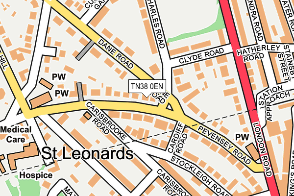
TN38 0EN is located in the Central St Leonards electoral ward, within the local authority district of Hastings and the English Parliamentary constituency of Hastings and Rye. The Sub Integrated Care Board (ICB) Location is NHS Sussex ICB - 97R and the police force is Sussex. This postcode has been in use since June 1999.


GetTheData
Source: OS OpenMap – Local (Ordnance Survey)
Source: OS VectorMap District (Ordnance Survey)
Licence: Open Government Licence (requires attribution)
| Easting | 580004 |
| Northing | 109371 |
| Latitude | 50.855839 |
| Longitude | 0.556081 |
GetTheData
Source: Open Postcode Geo
Licence: Open Government Licence
| Country | England |
| Postcode District | TN38 |
➜ See where TN38 is on a map ➜ Where is Hastings? | |
GetTheData
Source: Land Registry Price Paid Data
Licence: Open Government Licence
Elevation or altitude of TN38 0EN as distance above sea level:
| Metres | Feet | |
|---|---|---|
| Elevation | 50m | 164ft |
Elevation is measured from the approximate centre of the postcode, to the nearest point on an OS contour line from OS Terrain 50, which has contour spacing of ten vertical metres.
➜ How high above sea level am I? Find the elevation of your current position using your device's GPS.
GetTheData
Source: Open Postcode Elevation
Licence: Open Government Licence
| Ward | Central St Leonards |
| Constituency | Hastings And Rye |
GetTheData
Source: ONS Postcode Database
Licence: Open Government Licence
| Charles Road (Pevensey Road) | St Leonards | 52m |
| Charles Road (Pevensey Road) | St Leonards | 64m |
| St Johns Church (Pevensey Road) | St Leonards | 188m |
| Hatherley Road (London Road) | St Leonards | 193m |
| St Johns Church (Pevensey Road) | St Leonards | 215m |
| St Leonards Warrior Square Station | 0.3km |
| West St Leonards Station | 1.2km |
| Hastings Station | 1.5km |
GetTheData
Source: NaPTAN
Licence: Open Government Licence
GetTheData
Source: ONS Postcode Database
Licence: Open Government Licence


➜ Get more ratings from the Food Standards Agency
GetTheData
Source: Food Standards Agency
Licence: FSA terms & conditions
| Last Collection | |||
|---|---|---|---|
| Location | Mon-Fri | Sat | Distance |
| Pevensey Road | 17:45 | 12:15 | 26m |
| Carisbrooke Road | 17:45 | 12:15 | 161m |
| Upper Maze Hill | 17:45 | 12:00 | 254m |
GetTheData
Source: Dracos
Licence: Creative Commons Attribution-ShareAlike
The below table lists the International Territorial Level (ITL) codes (formerly Nomenclature of Territorial Units for Statistics (NUTS) codes) and Local Administrative Units (LAU) codes for TN38 0EN:
| ITL 1 Code | Name |
|---|---|
| TLJ | South East (England) |
| ITL 2 Code | Name |
| TLJ2 | Surrey, East and West Sussex |
| ITL 3 Code | Name |
| TLJ22 | East Sussex CC |
| LAU 1 Code | Name |
| E07000062 | Hastings |
GetTheData
Source: ONS Postcode Directory
Licence: Open Government Licence
The below table lists the Census Output Area (OA), Lower Layer Super Output Area (LSOA), and Middle Layer Super Output Area (MSOA) for TN38 0EN:
| Code | Name | |
|---|---|---|
| OA | E00106559 | |
| LSOA | E01020982 | Hastings 011A |
| MSOA | E02004378 | Hastings 011 |
GetTheData
Source: ONS Postcode Directory
Licence: Open Government Licence
| TN38 0QQ | Charles Road | 82m |
| TN38 0LE | Pevensey Road | 84m |
| TN38 0LF | Pevensey Road | 99m |
| TN38 0JN | Carisbrooke Road | 116m |
| TN38 0QW | Dane Road | 125m |
| TN38 0QA | Charles Road | 139m |
| TN38 0QE | Clyde Road | 139m |
| TN38 0JP | Stockleigh Road | 143m |
| TN38 0JZ | Pevensey Road | 148m |
| TN38 0JL | Kenilworth Road | 155m |
GetTheData
Source: Open Postcode Geo; Land Registry Price Paid Data
Licence: Open Government Licence