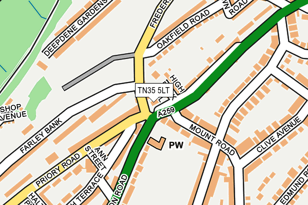
TN35 5LT is located in the Tressell electoral ward, within the local authority district of Hastings and the English Parliamentary constituency of Hastings and Rye. The Sub Integrated Care Board (ICB) Location is NHS Sussex ICB - 97R and the police force is Sussex. This postcode has been in use since January 1980.


GetTheData
Source: OS OpenMap – Local (Ordnance Survey)
Source: OS VectorMap District (Ordnance Survey)
Licence: Open Government Licence (requires attribution)
| Easting | 583125 |
| Northing | 110926 |
| Latitude | 50.868829 |
| Longitude | 0.601153 |
GetTheData
Source: Open Postcode Geo
Licence: Open Government Licence
| Country | England |
| Postcode District | TN35 |
➜ See where TN35 is on a map ➜ Where is Hastings? | |
GetTheData
Source: Land Registry Price Paid Data
Licence: Open Government Licence
Elevation or altitude of TN35 5LT as distance above sea level:
| Metres | Feet | |
|---|---|---|
| Elevation | 90m | 295ft |
Elevation is measured from the approximate centre of the postcode, to the nearest point on an OS contour line from OS Terrain 50, which has contour spacing of ten vertical metres.
➜ How high above sea level am I? Find the elevation of your current position using your device's GPS.
GetTheData
Source: Open Postcode Elevation
Licence: Open Government Licence
| Ward | Tressell |
| Constituency | Hastings And Rye |
GetTheData
Source: ONS Postcode Database
Licence: Open Government Licence
242, OLD LONDON ROAD, HASTINGS, TN35 5LT 2020 30 SEP £300,000 |
GetTheData
Source: HM Land Registry Price Paid Data
Licence: Contains HM Land Registry data © Crown copyright and database right 2025. This data is licensed under the Open Government Licence v3.0.
| North Terrace (Priory Road) | Ore | 71m |
| Mount Road (Old London Road) | Ore | 78m |
| North Terrace (Priory Road) | Ore | 90m |
| Richmond Street (Old London Road) | Halton | 140m |
| Richmond Street (Old London Road) | Halton | 175m |
| Ore Station | 0.7km |
| Hastings Station | 2.1km |
| St Leonards Warrior Square Station | 3.2km |
GetTheData
Source: NaPTAN
Licence: Open Government Licence
| Percentage of properties with Next Generation Access | 100.0% |
| Percentage of properties with Superfast Broadband | 100.0% |
| Percentage of properties with Ultrafast Broadband | 0.0% |
| Percentage of properties with Full Fibre Broadband | 0.0% |
Superfast Broadband is between 30Mbps and 300Mbps
Ultrafast Broadband is > 300Mbps
| Percentage of properties unable to receive 2Mbps | 0.0% |
| Percentage of properties unable to receive 5Mbps | 0.0% |
| Percentage of properties unable to receive 10Mbps | 0.0% |
| Percentage of properties unable to receive 30Mbps | 0.0% |
GetTheData
Source: Ofcom
Licence: Ofcom Terms of Use (requires attribution)
GetTheData
Source: ONS Postcode Database
Licence: Open Government Licence


➜ Get more ratings from the Food Standards Agency
GetTheData
Source: Food Standards Agency
Licence: FSA terms & conditions
| Last Collection | |||
|---|---|---|---|
| Location | Mon-Fri | Sat | Distance |
| Ore Post Office | 17:30 | 12:15 | 762m |
| St Georges Road Post Office | 17:30 | 12:00 | 1,077m |
| Priory Road | 17:30 | 12:00 | 1,188m |
GetTheData
Source: Dracos
Licence: Creative Commons Attribution-ShareAlike
The below table lists the International Territorial Level (ITL) codes (formerly Nomenclature of Territorial Units for Statistics (NUTS) codes) and Local Administrative Units (LAU) codes for TN35 5LT:
| ITL 1 Code | Name |
|---|---|
| TLJ | South East (England) |
| ITL 2 Code | Name |
| TLJ2 | Surrey, East and West Sussex |
| ITL 3 Code | Name |
| TLJ22 | East Sussex CC |
| LAU 1 Code | Name |
| E07000062 | Hastings |
GetTheData
Source: ONS Postcode Directory
Licence: Open Government Licence
The below table lists the Census Output Area (OA), Lower Layer Super Output Area (LSOA), and Middle Layer Super Output Area (MSOA) for TN35 5LT:
| Code | Name | |
|---|---|---|
| OA | E00106729 | |
| LSOA | E01021015 | Hastings 005D |
| MSOA | E02004372 | Hastings 005 |
GetTheData
Source: ONS Postcode Directory
Licence: Open Government Licence
| TN35 5AA | Frederick Road | 26m |
| TN35 5LS | High Bank Close | 52m |
| TN35 5AB | Laurel Cottages | 56m |
| TN35 5LA | Mount Road | 87m |
| TN34 3NS | Old London Road | 108m |
| TN34 3NN | Priory Road | 114m |
| TN34 3NW | Priory Road | 115m |
| TN35 5AX | Oakfield Road | 146m |
| TN35 5LR | Old London Road | 187m |
| TN35 5QA | Farley Bank | 194m |
GetTheData
Source: Open Postcode Geo; Land Registry Price Paid Data
Licence: Open Government Licence