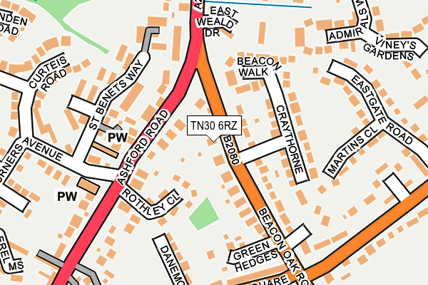
TN30 6RZ lies on Beacon Oak Road in Tenterden. TN30 6RZ is located in the Tenterden North electoral ward, within the local authority district of Ashford and the English Parliamentary constituency of Ashford. The Sub Integrated Care Board (ICB) Location is NHS Kent and Medway ICB - 91Q and the police force is Kent. This postcode has been in use since January 1980.


GetTheData
Source: OS OpenMap – Local (Ordnance Survey)
Source: OS VectorMap District (Ordnance Survey)
Licence: Open Government Licence (requires attribution)
| Easting | 588844 |
| Northing | 133930 |
| Latitude | 51.073621 |
| Longitude | 0.694271 |
GetTheData
Source: Open Postcode Geo
Licence: Open Government Licence
| Street | Beacon Oak Road |
| Town/City | Tenterden |
| Country | England |
| Postcode District | TN30 |
➜ See where TN30 is on a map ➜ Where is Tenterden? | |
GetTheData
Source: Land Registry Price Paid Data
Licence: Open Government Licence
Elevation or altitude of TN30 6RZ as distance above sea level:
| Metres | Feet | |
|---|---|---|
| Elevation | 60m | 197ft |
Elevation is measured from the approximate centre of the postcode, to the nearest point on an OS contour line from OS Terrain 50, which has contour spacing of ten vertical metres.
➜ How high above sea level am I? Find the elevation of your current position using your device's GPS.
GetTheData
Source: Open Postcode Elevation
Licence: Open Government Licence
| Ward | Tenterden North |
| Constituency | Ashford |
GetTheData
Source: ONS Postcode Database
Licence: Open Government Licence
2020 14 OCT £600,000 |
2003 2 OCT £400,000 |
1999 27 MAY £215,000 |
GetTheData
Source: HM Land Registry Price Paid Data
Licence: Contains HM Land Registry data © Crown copyright and database right 2025. This data is licensed under the Open Government Licence v3.0.
| Turners Avenue (Ashford Road) | Tenterden | 70m |
| Turners Avenue (Ashford Road) | Tenterden | 119m |
| Lime Hill (Woodchurch Road) | Tenterden | 230m |
| Homewood School (Ashford Road) | Tenterden | 296m |
| Homewood School (Ashford Road) | Tenterden | 372m |
| Tenterden Town Rail Station (Kesr) | Tenterden | 744m |
GetTheData
Source: NaPTAN
Licence: Open Government Licence
| Percentage of properties with Next Generation Access | 100.0% |
| Percentage of properties with Superfast Broadband | 100.0% |
| Percentage of properties with Ultrafast Broadband | 0.0% |
| Percentage of properties with Full Fibre Broadband | 0.0% |
Superfast Broadband is between 30Mbps and 300Mbps
Ultrafast Broadband is > 300Mbps
| Percentage of properties unable to receive 2Mbps | 0.0% |
| Percentage of properties unable to receive 5Mbps | 0.0% |
| Percentage of properties unable to receive 10Mbps | 0.0% |
| Percentage of properties unable to receive 30Mbps | 0.0% |
GetTheData
Source: Ofcom
Licence: Ofcom Terms of Use (requires attribution)
GetTheData
Source: ONS Postcode Database
Licence: Open Government Licence


➜ Get more ratings from the Food Standards Agency
GetTheData
Source: Food Standards Agency
Licence: FSA terms & conditions
| Last Collection | |||
|---|---|---|---|
| Location | Mon-Fri | Sat | Distance |
| Tenterden Sorting Office | 17:30 | 11:30 | 395m |
| Railway Station | 16:00 | 10:00 | 771m |
| Henley Meadows | 16:30 | 09:00 | 772m |
GetTheData
Source: Dracos
Licence: Creative Commons Attribution-ShareAlike
The below table lists the International Territorial Level (ITL) codes (formerly Nomenclature of Territorial Units for Statistics (NUTS) codes) and Local Administrative Units (LAU) codes for TN30 6RZ:
| ITL 1 Code | Name |
|---|---|
| TLJ | South East (England) |
| ITL 2 Code | Name |
| TLJ4 | Kent |
| ITL 3 Code | Name |
| TLJ45 | Mid Kent |
| LAU 1 Code | Name |
| E07000105 | Ashford |
GetTheData
Source: ONS Postcode Directory
Licence: Open Government Licence
The below table lists the Census Output Area (OA), Lower Layer Super Output Area (LSOA), and Middle Layer Super Output Area (MSOA) for TN30 6RZ:
| Code | Name | |
|---|---|---|
| OA | E00121982 | |
| LSOA | E01024026 | Ashford 014C |
| MSOA | E02005009 | Ashford 014 |
GetTheData
Source: ONS Postcode Directory
Licence: Open Government Licence
| TN30 6SB | Craythorne | 50m |
| TN30 6LR | Ashford Road | 70m |
| TN30 6SA | Craythorne | 87m |
| TN30 6LP | Rothley Close | 100m |
| TN30 6RY | Beacon Oak Road | 124m |
| TN30 6SD | Craythorne | 129m |
| TN30 6SF | Beacon Walk | 136m |
| TN30 6QS | St Benets Court | 138m |
| TN30 6RW | Beacon Oak Road | 159m |
| TN30 6QT | St Benets Way | 172m |
GetTheData
Source: Open Postcode Geo; Land Registry Price Paid Data
Licence: Open Government Licence