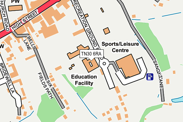
TN30 6RA is located in the Tenterden South electoral ward, within the local authority district of Ashford and the English Parliamentary constituency of Ashford. The Sub Integrated Care Board (ICB) Location is NHS Kent and Medway ICB - 91Q and the police force is Kent. This postcode has been in use since January 1980.


GetTheData
Source: OS OpenMap – Local (Ordnance Survey)
Source: OS VectorMap District (Ordnance Survey)
Licence: Open Government Licence (requires attribution)
| Easting | 588615 |
| Northing | 133196 |
| Latitude | 51.067101 |
| Longitude | 0.690656 |
GetTheData
Source: Open Postcode Geo
Licence: Open Government Licence
| Country | England |
| Postcode District | TN30 |
➜ See where TN30 is on a map ➜ Where is Tenterden? | |
GetTheData
Source: Land Registry Price Paid Data
Licence: Open Government Licence
Elevation or altitude of TN30 6RA as distance above sea level:
| Metres | Feet | |
|---|---|---|
| Elevation | 60m | 197ft |
Elevation is measured from the approximate centre of the postcode, to the nearest point on an OS contour line from OS Terrain 50, which has contour spacing of ten vertical metres.
➜ How high above sea level am I? Find the elevation of your current position using your device's GPS.
GetTheData
Source: Open Postcode Elevation
Licence: Open Government Licence
| Ward | Tenterden South |
| Constituency | Ashford |
GetTheData
Source: ONS Postcode Database
Licence: Open Government Licence
| Town Hall (High Street) | Tenterden | 242m |
| Town Hall (High Street) | Tenterden | 242m |
| East Cross (Oaks Road) | Tenterden | 327m |
| East Cross (Oaks Road) | Tenterden | 342m |
| The Vine (High Street) | Tenterden | 357m |
| Tenterden Town Rail Station (Kesr) | Tenterden | 514m |
GetTheData
Source: NaPTAN
Licence: Open Government Licence
GetTheData
Source: ONS Postcode Database
Licence: Open Government Licence


➜ Get more ratings from the Food Standards Agency
GetTheData
Source: Food Standards Agency
Licence: FSA terms & conditions
| Last Collection | |||
|---|---|---|---|
| Location | Mon-Fri | Sat | Distance |
| Tenterden Post Office | 17:15 | 11:15 | 445m |
| Tenterden Sorting Office | 17:30 | 11:30 | 460m |
| Railway Station | 16:00 | 10:00 | 523m |
GetTheData
Source: Dracos
Licence: Creative Commons Attribution-ShareAlike
The below table lists the International Territorial Level (ITL) codes (formerly Nomenclature of Territorial Units for Statistics (NUTS) codes) and Local Administrative Units (LAU) codes for TN30 6RA:
| ITL 1 Code | Name |
|---|---|
| TLJ | South East (England) |
| ITL 2 Code | Name |
| TLJ4 | Kent |
| ITL 3 Code | Name |
| TLJ45 | Mid Kent |
| LAU 1 Code | Name |
| E07000105 | Ashford |
GetTheData
Source: ONS Postcode Directory
Licence: Open Government Licence
The below table lists the Census Output Area (OA), Lower Layer Super Output Area (LSOA), and Middle Layer Super Output Area (MSOA) for TN30 6RA:
| Code | Name | |
|---|---|---|
| OA | E00121979 | |
| LSOA | E01024025 | Ashford 013F |
| MSOA | E02005008 | Ashford 013 |
GetTheData
Source: ONS Postcode Directory
Licence: Open Government Licence
| TN30 6EX | Six Fields | 145m |
| TN30 6ES | Bells Lane | 201m |
| TN30 6ET | Theatre Square | 201m |
| TN30 6BJ | High Street | 239m |
| TN30 6AP | High Street | 256m |
| TN30 6RG | The Croft | 257m |
| TN30 6AH | East Well | 260m |
| TN30 6EY | Bridewell Lane | 270m |
| TN30 6AR | High Street | 276m |
| TN30 6BD | High Street | 284m |
GetTheData
Source: Open Postcode Geo; Land Registry Price Paid Data
Licence: Open Government Licence