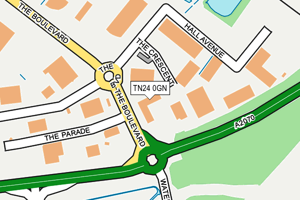
TN24 0GN is located in the Aylesford & East Stour electoral ward, within the local authority district of Ashford and the English Parliamentary constituency of Ashford. The Sub Integrated Care Board (ICB) Location is NHS Kent and Medway ICB - 91Q and the police force is Kent. This postcode has been in use since December 1999.


GetTheData
Source: OS OpenMap – Local (Ordnance Survey)
Source: OS VectorMap District (Ordnance Survey)
Licence: Open Government Licence (requires attribution)
| Easting | 602977 |
| Northing | 140463 |
| Latitude | 51.127471 |
| Longitude | 0.899448 |
GetTheData
Source: Open Postcode Geo
Licence: Open Government Licence
| Country | England |
| Postcode District | TN24 |
➜ See where TN24 is on a map ➜ Where is Ashford? | |
GetTheData
Source: Land Registry Price Paid Data
Licence: Open Government Licence
Elevation or altitude of TN24 0GN as distance above sea level:
| Metres | Feet | |
|---|---|---|
| Elevation | 40m | 131ft |
Elevation is measured from the approximate centre of the postcode, to the nearest point on an OS contour line from OS Terrain 50, which has contour spacing of ten vertical metres.
➜ How high above sea level am I? Find the elevation of your current position using your device's GPS.
GetTheData
Source: Open Postcode Elevation
Licence: Open Government Licence
| Ward | Aylesford & East Stour |
| Constituency | Ashford |
GetTheData
Source: ONS Postcode Database
Licence: Open Government Licence
| Caffyns (Monument Way) | Orbital Business Park | 190m |
| Bp Travel (The Boulevard) | Orbital Business Park | 364m |
| Ashford Market (Monument Way) | Orbital Business Park | 508m |
| Pirtek (The Long Barrow) | Orbital Business Park | 516m |
| Ashford Market (Monument Way) | Orbital Business Park | 649m |
| Ashford International Station | 2.4km |
GetTheData
Source: NaPTAN
Licence: Open Government Licence
GetTheData
Source: ONS Postcode Database
Licence: Open Government Licence


➜ Get more ratings from the Food Standards Agency
GetTheData
Source: Food Standards Agency
Licence: FSA terms & conditions
| Last Collection | |||
|---|---|---|---|
| Location | Mon-Fri | Sat | Distance |
| Church Road | 17:00 | 10:30 | 686m |
| South Willesborough P.o. | 17:15 | 12:15 | 907m |
| Earlsworth Road | 17:30 | 12:15 | 1,078m |
GetTheData
Source: Dracos
Licence: Creative Commons Attribution-ShareAlike
The below table lists the International Territorial Level (ITL) codes (formerly Nomenclature of Territorial Units for Statistics (NUTS) codes) and Local Administrative Units (LAU) codes for TN24 0GN:
| ITL 1 Code | Name |
|---|---|
| TLJ | South East (England) |
| ITL 2 Code | Name |
| TLJ4 | Kent |
| ITL 3 Code | Name |
| TLJ45 | Mid Kent |
| LAU 1 Code | Name |
| E07000105 | Ashford |
GetTheData
Source: ONS Postcode Directory
Licence: Open Government Licence
The below table lists the Census Output Area (OA), Lower Layer Super Output Area (LSOA), and Middle Layer Super Output Area (MSOA) for TN24 0GN:
| Code | Name | |
|---|---|---|
| OA | E00121830 | |
| LSOA | E01023996 | Ashford 006C |
| MSOA | E02005001 | Ashford 006 |
GetTheData
Source: ONS Postcode Directory
Licence: Open Government Licence
| TN24 0TL | The Glenmore Centre | 461m |
| TN24 0FE | Foster Road | 476m |
| TN24 0SG | Barrey Road | 497m |
| TN24 0SJ | St Johns Court | 560m |
| TN24 0SH | Foster Road | 577m |
| TN24 0LD | Church Road | 612m |
| TN24 0BF | Surtees Close | 721m |
| TN24 0LF | Church Road | 721m |
| TN24 0BN | Canterbury Road | 722m |
| TN24 0LE | Church Road | 729m |
GetTheData
Source: Open Postcode Geo; Land Registry Price Paid Data
Licence: Open Government Licence