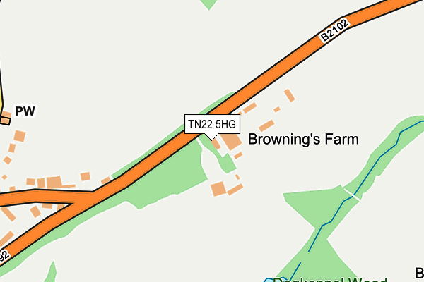
TN22 5HG lies on Lewes Road in Blackboys, Uckfield. TN22 5HG is located in the Framfield & Cross-in-Hand electoral ward, within the local authority district of Wealden and the English Parliamentary constituency of Wealden. The Sub Integrated Care Board (ICB) Location is NHS Sussex ICB - 97R and the police force is Sussex. This postcode has been in use since January 1980.


GetTheData
Source: OS OpenMap – Local (Ordnance Survey)
Source: OS VectorMap District (Ordnance Survey)
Licence: Open Government Licence (requires attribution)
| Easting | 552939 |
| Northing | 120826 |
| Latitude | 50.966554 |
| Longitude | 0.176695 |
GetTheData
Source: Open Postcode Geo
Licence: Open Government Licence
| Street | Lewes Road |
| Locality | Blackboys |
| Town/City | Uckfield |
| Country | England |
| Postcode District | TN22 |
➜ See where TN22 is on a map | |
GetTheData
Source: Land Registry Price Paid Data
Licence: Open Government Licence
Elevation or altitude of TN22 5HG as distance above sea level:
| Metres | Feet | |
|---|---|---|
| Elevation | 100m | 328ft |
Elevation is measured from the approximate centre of the postcode, to the nearest point on an OS contour line from OS Terrain 50, which has contour spacing of ten vertical metres.
➜ How high above sea level am I? Find the elevation of your current position using your device's GPS.
GetTheData
Source: Open Postcode Elevation
Licence: Open Government Licence
| Ward | Framfield & Cross-in-hand |
| Constituency | Wealden |
GetTheData
Source: ONS Postcode Database
Licence: Open Government Licence
| High Street (B2102) | Blackboys | 232m |
| High Street (B2102) | Blackboys | 263m |
| Gun Road (B2102) | Blackboys | 782m |
| Gun Road (B2102) | Blackboys | 810m |
| Buxted Station | 4.1km |
GetTheData
Source: NaPTAN
Licence: Open Government Licence
| Percentage of properties with Next Generation Access | 100.0% |
| Percentage of properties with Superfast Broadband | 100.0% |
| Percentage of properties with Ultrafast Broadband | 0.0% |
| Percentage of properties with Full Fibre Broadband | 0.0% |
Superfast Broadband is between 30Mbps and 300Mbps
Ultrafast Broadband is > 300Mbps
| Median download speed | 29.9Mbps |
| Average download speed | 31.5Mbps |
| Maximum download speed | 69.64Mbps |
| Median upload speed | 2.5Mbps |
| Average upload speed | 4.6Mbps |
| Maximum upload speed | 12.98Mbps |
| Percentage of properties unable to receive 2Mbps | 0.0% |
| Percentage of properties unable to receive 5Mbps | 0.0% |
| Percentage of properties unable to receive 10Mbps | 0.0% |
| Percentage of properties unable to receive 30Mbps | 0.0% |
GetTheData
Source: Ofcom
Licence: Ofcom Terms of Use (requires attribution)
GetTheData
Source: ONS Postcode Database
Licence: Open Government Licence


➜ Get more ratings from the Food Standards Agency
GetTheData
Source: Food Standards Agency
Licence: FSA terms & conditions
| Last Collection | |||
|---|---|---|---|
| Location | Mon-Fri | Sat | Distance |
| Sharlands | 16:15 | 09:00 | 446m |
| School Lane | 16:45 | 09:00 | 761m |
| Blackboys Old Post Office | 17:00 | 10:00 | 811m |
GetTheData
Source: Dracos
Licence: Creative Commons Attribution-ShareAlike
The below table lists the International Territorial Level (ITL) codes (formerly Nomenclature of Territorial Units for Statistics (NUTS) codes) and Local Administrative Units (LAU) codes for TN22 5HG:
| ITL 1 Code | Name |
|---|---|
| TLJ | South East (England) |
| ITL 2 Code | Name |
| TLJ2 | Surrey, East and West Sussex |
| ITL 3 Code | Name |
| TLJ22 | East Sussex CC |
| LAU 1 Code | Name |
| E07000065 | Wealden |
GetTheData
Source: ONS Postcode Directory
Licence: Open Government Licence
The below table lists the Census Output Area (OA), Lower Layer Super Output Area (LSOA), and Middle Layer Super Output Area (MSOA) for TN22 5HG:
| Code | Name | |
|---|---|---|
| OA | E00107546 | |
| LSOA | E01021170 | Wealden 008C |
| MSOA | E02004410 | Wealden 008 |
GetTheData
Source: ONS Postcode Directory
Licence: Open Government Licence
| TN22 5JR | High Street | 217m |
| TN22 5JS | High Street | 254m |
| TN22 5JT | High Street | 292m |
| TN22 5LD | Star Lane | 378m |
| TN22 5LE | Lewes Road | 418m |
| TN22 5LB | Chapel Lane | 464m |
| TN22 5JU | High Street | 510m |
| TN22 5LA | Green Lane | 629m |
| TN22 5HE | 629m | |
| TN22 5LH | Mount Pleasant | 650m |
GetTheData
Source: Open Postcode Geo; Land Registry Price Paid Data
Licence: Open Government Licence