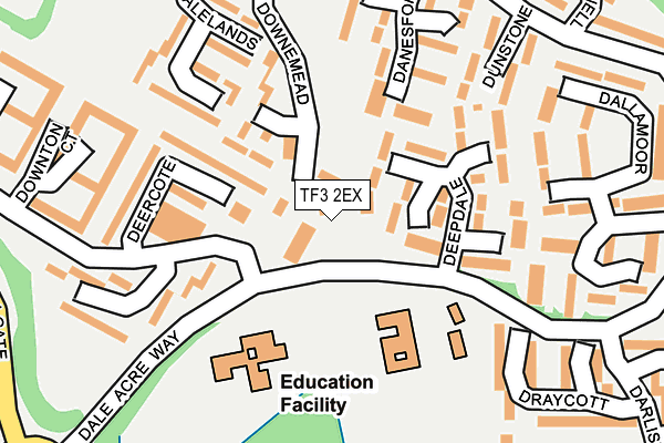
TF3 2EX is located in the The Nedge electoral ward, within the unitary authority of Telford and Wrekin and the English Parliamentary constituency of Telford. The Sub Integrated Care Board (ICB) Location is NHS Shropshire, Telford and Wrekin ICB - M2L0M and the police force is West Mercia. This postcode has been in use since May 2016.


GetTheData
Source: OS OpenMap – Local (Ordnance Survey)
Source: OS VectorMap District (Ordnance Survey)
Licence: Open Government Licence (requires attribution)
| Easting | 370532 |
| Northing | 308490 |
| Latitude | 52.673323 |
| Longitude | -2.437238 |
GetTheData
Source: Open Postcode Geo
Licence: Open Government Licence
| Country | England |
| Postcode District | TF3 |
➜ See where TF3 is on a map ➜ Where is Telford? | |
GetTheData
Source: Land Registry Price Paid Data
Licence: Open Government Licence
Elevation or altitude of TF3 2EX as distance above sea level:
| Metres | Feet | |
|---|---|---|
| Elevation | 130m | 427ft |
Elevation is measured from the approximate centre of the postcode, to the nearest point on an OS contour line from OS Terrain 50, which has contour spacing of ten vertical metres.
➜ How high above sea level am I? Find the elevation of your current position using your device's GPS.
GetTheData
Source: Open Postcode Elevation
Licence: Open Government Licence
| Ward | The Nedge |
| Constituency | Telford |
GetTheData
Source: ONS Postcode Database
Licence: Open Government Licence
| Deercote (Dale Acre Way) | Hollinswood | 67m |
| Deercote (Dale Acre Way) | Hollinswood | 117m |
| Duffryn (Dale Acre Way) | Hollinswood | 224m |
| Duffryn (Dale Acre Way) | Hollinswood | 272m |
| International Centre Coach Stop A (St Quentin Gate) | Telford Town Centre | 281m |
| Telford Central Station | 0.9km |
| Oakengates Station | 2.4km |
| Shifnal Station | 4.5km |
GetTheData
Source: NaPTAN
Licence: Open Government Licence
GetTheData
Source: ONS Postcode Database
Licence: Open Government Licence


➜ Get more ratings from the Food Standards Agency
GetTheData
Source: Food Standards Agency
Licence: FSA terms & conditions
| Last Collection | |||
|---|---|---|---|
| Location | Mon-Fri | Sat | Distance |
| Downmead | 17:15 | 11:15 | 26m |
| Telford Centre Post Office | 17:30 | 12:15 | 698m |
| Stafford Park 17 | 18:15 | 11:30 | 792m |
GetTheData
Source: Dracos
Licence: Creative Commons Attribution-ShareAlike
The below table lists the International Territorial Level (ITL) codes (formerly Nomenclature of Territorial Units for Statistics (NUTS) codes) and Local Administrative Units (LAU) codes for TF3 2EX:
| ITL 1 Code | Name |
|---|---|
| TLG | West Midlands (England) |
| ITL 2 Code | Name |
| TLG2 | Shropshire and Staffordshire |
| ITL 3 Code | Name |
| TLG21 | Telford and Wrekin |
| LAU 1 Code | Name |
| E06000020 | Telford and Wrekin |
GetTheData
Source: ONS Postcode Directory
Licence: Open Government Licence
The below table lists the Census Output Area (OA), Lower Layer Super Output Area (LSOA), and Middle Layer Super Output Area (MSOA) for TF3 2EX:
| Code | Name | |
|---|---|---|
| OA | E00071667 | |
| LSOA | E01014191 | Telford and Wrekin 018A |
| MSOA | E02002945 | Telford and Wrekin 018 |
GetTheData
Source: ONS Postcode Directory
Licence: Open Government Licence
| TF3 2EW | Downemead | 71m |
| TF3 2BH | Deercote | 91m |
| TF3 2EJ | Deepdale | 107m |
| TF3 2BQ | Deercote | 111m |
| TF3 2EL | Deepdale | 119m |
| TF3 2BW | Deercote | 125m |
| TF3 2DY | Danesford | 144m |
| TF3 2DX | Danesford | 146m |
| TF3 2BB | Dalelands | 150m |
| TF3 2EQ | Deepdale | 157m |
GetTheData
Source: Open Postcode Geo; Land Registry Price Paid Data
Licence: Open Government Licence