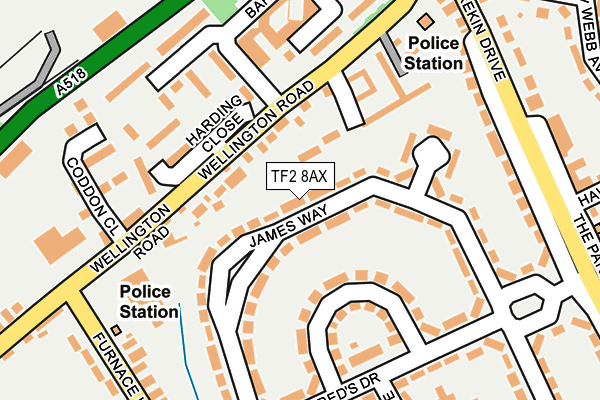
TF2 8AX lies on James Way in Donnington, Telford. TF2 8AX is located in the Donnington electoral ward, within the unitary authority of Telford and Wrekin and the English Parliamentary constituency of The Wrekin. The Sub Integrated Care Board (ICB) Location is NHS Shropshire, Telford and Wrekin ICB - M2L0M and the police force is West Mercia. This postcode has been in use since January 1980.


GetTheData
Source: OS OpenMap – Local (Ordnance Survey)
Source: OS VectorMap District (Ordnance Survey)
Licence: Open Government Licence (requires attribution)
| Easting | 370121 |
| Northing | 313392 |
| Latitude | 52.717351 |
| Longitude | -2.443764 |
GetTheData
Source: Open Postcode Geo
Licence: Open Government Licence
| Street | James Way |
| Locality | Donnington |
| Town/City | Telford |
| Country | England |
| Postcode District | TF2 |
➜ See where TF2 is on a map ➜ Where is Telford? | |
GetTheData
Source: Land Registry Price Paid Data
Licence: Open Government Licence
Elevation or altitude of TF2 8AX as distance above sea level:
| Metres | Feet | |
|---|---|---|
| Elevation | 80m | 262ft |
Elevation is measured from the approximate centre of the postcode, to the nearest point on an OS contour line from OS Terrain 50, which has contour spacing of ten vertical metres.
➜ How high above sea level am I? Find the elevation of your current position using your device's GPS.
GetTheData
Source: Open Postcode Elevation
Licence: Open Government Licence
| Ward | Donnington |
| Constituency | The Wrekin |
GetTheData
Source: ONS Postcode Database
Licence: Open Government Licence
| Police Station (Wellington Road) | Donnington | 163m |
| Leonard Close (Winifreds Drive) | Donnington | 188m |
| The Shawbirch (Wellington Road) | Trench | 190m |
| Police Station (Wellington Road) | Donnington | 198m |
| Leonard Close (Winifreds Drive) | Donnington | 209m |
| Oakengates Station | 2.7km |
| Telford Central Station | 4km |
| Wellington (Shropshire) Station | 5.3km |
GetTheData
Source: NaPTAN
Licence: Open Government Licence
| Percentage of properties with Next Generation Access | 100.0% |
| Percentage of properties with Superfast Broadband | 100.0% |
| Percentage of properties with Ultrafast Broadband | 100.0% |
| Percentage of properties with Full Fibre Broadband | 0.0% |
Superfast Broadband is between 30Mbps and 300Mbps
Ultrafast Broadband is > 300Mbps
| Median download speed | 71.6Mbps |
| Average download speed | 91.5Mbps |
| Maximum download speed | 350.00Mbps |
| Median upload speed | 8.9Mbps |
| Average upload speed | 8.3Mbps |
| Maximum upload speed | 20.00Mbps |
| Percentage of properties unable to receive 2Mbps | 0.0% |
| Percentage of properties unable to receive 5Mbps | 0.0% |
| Percentage of properties unable to receive 10Mbps | 0.0% |
| Percentage of properties unable to receive 30Mbps | 0.0% |
GetTheData
Source: Ofcom
Licence: Ofcom Terms of Use (requires attribution)
Estimated total energy consumption in TF2 8AX by fuel type, 2015.
| Consumption (kWh) | 416,559 |
|---|---|
| Meter count | 38 |
| Mean (kWh/meter) | 10,962 |
| Median (kWh/meter) | 10,034 |
| Consumption (kWh) | 119,737 |
|---|---|
| Meter count | 31 |
| Mean (kWh/meter) | 3,862 |
| Median (kWh/meter) | 3,664 |
GetTheData
Source: Postcode level gas estimates: 2015 (experimental)
Source: Postcode level electricity estimates: 2015 (experimental)
Licence: Open Government Licence
GetTheData
Source: ONS Postcode Database
Licence: Open Government Licence


➜ Get more ratings from the Food Standards Agency
GetTheData
Source: Food Standards Agency
Licence: FSA terms & conditions
| Last Collection | |||
|---|---|---|---|
| Location | Mon-Fri | Sat | Distance |
| Trench Road | 16:45 | 12:15 | 303m |
| Wellington Road Post Office | 17:00 | 11:30 | 1,073m |
| Tf2 Oakengates Post Office, Limes Walk, Oakengates | 18:30 | 12:15 | 2,436m |
GetTheData
Source: Dracos
Licence: Creative Commons Attribution-ShareAlike
The below table lists the International Territorial Level (ITL) codes (formerly Nomenclature of Territorial Units for Statistics (NUTS) codes) and Local Administrative Units (LAU) codes for TF2 8AX:
| ITL 1 Code | Name |
|---|---|
| TLG | West Midlands (England) |
| ITL 2 Code | Name |
| TLG2 | Shropshire and Staffordshire |
| ITL 3 Code | Name |
| TLG21 | Telford and Wrekin |
| LAU 1 Code | Name |
| E06000020 | Telford and Wrekin |
GetTheData
Source: ONS Postcode Directory
Licence: Open Government Licence
The below table lists the Census Output Area (OA), Lower Layer Super Output Area (LSOA), and Middle Layer Super Output Area (MSOA) for TF2 8AX:
| Code | Name | |
|---|---|---|
| OA | E00071350 | |
| LSOA | E01014125 | Telford and Wrekin 005A |
| MSOA | E02002932 | Telford and Wrekin 005 |
GetTheData
Source: ONS Postcode Directory
Licence: Open Government Licence
| TF2 8AB | Wellington Road | 68m |
| TF2 8AU | James Way | 152m |
| TF2 8AY | James Way | 153m |
| TF2 8BA | Winifreds Drive | 167m |
| TF2 8AZ | James Way | 186m |
| TF2 8AL | Algernon Court | 188m |
| TF2 8DT | Wrekin Drive | 208m |
| TF2 8BB | Winifreds Drive | 210m |
| TF2 7HY | Furnace Lane | 228m |
| TF2 8BE | Leonard Close | 244m |
GetTheData
Source: Open Postcode Geo; Land Registry Price Paid Data
Licence: Open Government Licence