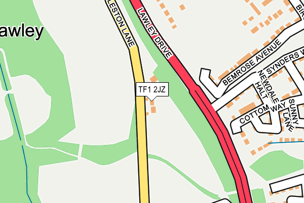
TF1 2JZ is in Newdale, Telford. TF1 2JZ is located in the Lawley electoral ward, within the unitary authority of Telford and Wrekin and the English Parliamentary constituency of The Wrekin. The Sub Integrated Care Board (ICB) Location is NHS Shropshire, Telford and Wrekin ICB - M2L0M and the police force is West Mercia. This postcode has been in use since March 1982.


GetTheData
Source: OS OpenMap – Local (Ordnance Survey)
Source: OS VectorMap District (Ordnance Survey)
Licence: Open Government Licence (requires attribution)
| Easting | 367174 |
| Northing | 309479 |
| Latitude | 52.682005 |
| Longitude | -2.486998 |
GetTheData
Source: Open Postcode Geo
Licence: Open Government Licence
| Locality | Newdale |
| Town/City | Telford |
| Country | England |
| Postcode District | TF1 |
➜ See where TF1 is on a map ➜ Where is Telford? | |
GetTheData
Source: Land Registry Price Paid Data
Licence: Open Government Licence
Elevation or altitude of TF1 2JZ as distance above sea level:
| Metres | Feet | |
|---|---|---|
| Elevation | 150m | 492ft |
Elevation is measured from the approximate centre of the postcode, to the nearest point on an OS contour line from OS Terrain 50, which has contour spacing of ten vertical metres.
➜ How high above sea level am I? Find the elevation of your current position using your device's GPS.
GetTheData
Source: Open Postcode Elevation
Licence: Open Government Licence
| Ward | Lawley |
| Constituency | The Wrekin |
GetTheData
Source: ONS Postcode Database
Licence: Open Government Licence
2015 29 JUN £395,000 |
BROMLEY HOUSE, NEWDALE, TELFORD, TF1 2JZ 2005 28 OCT £310,000 |
BROMLEY HOUSE, NEWDALE, TELFORD, TF1 2JZ 2004 7 MAY £240,000 |
2002 2 AUG £166,000 |
GetTheData
Source: HM Land Registry Price Paid Data
Licence: Contains HM Land Registry data © Crown copyright and database right 2025. This data is licensed under the Open Government Licence v3.0.
| Newdale Halt (Synders Way) | Lawley | 219m |
| Community Centre (Glendale) | Lawley | 279m |
| Primary School (Arleston Lane) | Lawley | 357m |
| Miriam Lane (Birchfield Way) | Lawley | 421m |
| The Foxholes (Birchfield Way) | Lawley | 498m |
| Oakengates Station | 2.8km |
| Wellington (Shropshire) Station | 3km |
| Telford Central Station | 3.1km |
GetTheData
Source: NaPTAN
Licence: Open Government Licence
| Percentage of properties with Next Generation Access | 100.0% |
| Percentage of properties with Superfast Broadband | 100.0% |
| Percentage of properties with Ultrafast Broadband | 0.0% |
| Percentage of properties with Full Fibre Broadband | 0.0% |
Superfast Broadband is between 30Mbps and 300Mbps
Ultrafast Broadband is > 300Mbps
| Percentage of properties unable to receive 2Mbps | 0.0% |
| Percentage of properties unable to receive 5Mbps | 0.0% |
| Percentage of properties unable to receive 10Mbps | 0.0% |
| Percentage of properties unable to receive 30Mbps | 0.0% |
GetTheData
Source: Ofcom
Licence: Ofcom Terms of Use (requires attribution)
GetTheData
Source: ONS Postcode Database
Licence: Open Government Licence


➜ Get more ratings from the Food Standards Agency
GetTheData
Source: Food Standards Agency
Licence: FSA terms & conditions
| Last Collection | |||
|---|---|---|---|
| Location | Mon-Fri | Sat | Distance |
| Tesco | 18:00 | 12:00 | 944m |
| Overdale Post Office | 17:15 | 11:00 | 998m |
| The Rock | 14:45 | 11:30 | 1,027m |
GetTheData
Source: Dracos
Licence: Creative Commons Attribution-ShareAlike
The below table lists the International Territorial Level (ITL) codes (formerly Nomenclature of Territorial Units for Statistics (NUTS) codes) and Local Administrative Units (LAU) codes for TF1 2JZ:
| ITL 1 Code | Name |
|---|---|
| TLG | West Midlands (England) |
| ITL 2 Code | Name |
| TLG2 | Shropshire and Staffordshire |
| ITL 3 Code | Name |
| TLG21 | Telford and Wrekin |
| LAU 1 Code | Name |
| E06000020 | Telford and Wrekin |
GetTheData
Source: ONS Postcode Directory
Licence: Open Government Licence
The below table lists the Census Output Area (OA), Lower Layer Super Output Area (LSOA), and Middle Layer Super Output Area (MSOA) for TF1 2JZ:
| Code | Name | |
|---|---|---|
| OA | E00173124 | |
| LSOA | E01014202 | Telford and Wrekin 010D |
| MSOA | E02002937 | Telford and Wrekin 010 |
GetTheData
Source: ONS Postcode Directory
Licence: Open Government Licence
| TF3 5GH | Dobbins Lane | 222m |
| TF3 5GF | Newdale Halt | 236m |
| TF3 5GG | Cottom Way | 240m |
| TF3 5GE | Synders Way | 244m |
| TF3 5GB | Sunny Lane | 274m |
| TF4 2FH | Well Croft | 298m |
| TF3 5GD | Higgs Row | 306m |
| TF4 2BF | Glendale | 326m |
| TF3 5GU | Wulfgeat Lane | 329m |
| TF3 5GA | Symon Fold | 349m |
GetTheData
Source: Open Postcode Geo; Land Registry Price Paid Data
Licence: Open Government Licence