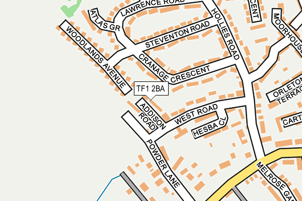
TF1 2BA lies on Addison Road in Wellington, Telford. TF1 2BA is located in the Haygate & Park electoral ward, within the unitary authority of Telford and Wrekin and the English Parliamentary constituency of The Wrekin. The Sub Integrated Care Board (ICB) Location is NHS Shropshire, Telford and Wrekin ICB - M2L0M and the police force is West Mercia. This postcode has been in use since January 1980.


GetTheData
Source: OS OpenMap – Local (Ordnance Survey)
Source: OS VectorMap District (Ordnance Survey)
Licence: Open Government Licence (requires attribution)
| Easting | 364266 |
| Northing | 311380 |
| Latitude | 52.698908 |
| Longitude | -2.530218 |
GetTheData
Source: Open Postcode Geo
Licence: Open Government Licence
| Street | Addison Road |
| Locality | Wellington |
| Town/City | Telford |
| Country | England |
| Postcode District | TF1 |
➜ See where TF1 is on a map ➜ Where is Telford? | |
GetTheData
Source: Land Registry Price Paid Data
Licence: Open Government Licence
Elevation or altitude of TF1 2BA as distance above sea level:
| Metres | Feet | |
|---|---|---|
| Elevation | 100m | 328ft |
Elevation is measured from the approximate centre of the postcode, to the nearest point on an OS contour line from OS Terrain 50, which has contour spacing of ten vertical metres.
➜ How high above sea level am I? Find the elevation of your current position using your device's GPS.
GetTheData
Source: Open Postcode Elevation
Licence: Open Government Licence
| Ward | Haygate & Park |
| Constituency | The Wrekin |
GetTheData
Source: ONS Postcode Database
Licence: Open Government Licence
| Powder Lane (Haygate Road) | Wellington | 220m |
| Powder Lane (Haygate Road) | Wellington | 238m |
| Melrose Gardens (Haygate Road) | Wellington | 269m |
| Mansell Road (Haygate Road) | Wellington | 398m |
| Bowing (Herbert Avenue) | Wellington | 407m |
| Wellington (Shropshire) Station | 0.9km |
GetTheData
Source: NaPTAN
Licence: Open Government Licence
| Percentage of properties with Next Generation Access | 100.0% |
| Percentage of properties with Superfast Broadband | 100.0% |
| Percentage of properties with Ultrafast Broadband | 100.0% |
| Percentage of properties with Full Fibre Broadband | 0.0% |
Superfast Broadband is between 30Mbps and 300Mbps
Ultrafast Broadband is > 300Mbps
| Median download speed | 39.1Mbps |
| Average download speed | 68.0Mbps |
| Maximum download speed | 350.00Mbps |
| Median upload speed | 1.3Mbps |
| Average upload speed | 3.7Mbps |
| Maximum upload speed | 10.00Mbps |
| Percentage of properties unable to receive 2Mbps | 0.0% |
| Percentage of properties unable to receive 5Mbps | 0.0% |
| Percentage of properties unable to receive 10Mbps | 0.0% |
| Percentage of properties unable to receive 30Mbps | 0.0% |
GetTheData
Source: Ofcom
Licence: Ofcom Terms of Use (requires attribution)
Estimated total energy consumption in TF1 2BA by fuel type, 2015.
| Consumption (kWh) | 158,195 |
|---|---|
| Meter count | 16 |
| Mean (kWh/meter) | 9,887 |
| Median (kWh/meter) | 8,624 |
| Consumption (kWh) | 36,420 |
|---|---|
| Meter count | 14 |
| Mean (kWh/meter) | 2,601 |
| Median (kWh/meter) | 2,735 |
GetTheData
Source: Postcode level gas estimates: 2015 (experimental)
Source: Postcode level electricity estimates: 2015 (experimental)
Licence: Open Government Licence
GetTheData
Source: ONS Postcode Database
Licence: Open Government Licence


➜ Get more ratings from the Food Standards Agency
GetTheData
Source: Food Standards Agency
Licence: FSA terms & conditions
| Last Collection | |||
|---|---|---|---|
| Location | Mon-Fri | Sat | Distance |
| Lawrence Road | 16:15 | 10:45 | 192m |
| Haygate Road | 16:15 | 10:45 | 234m |
| Mansell Road | 16:30 | 10:45 | 386m |
GetTheData
Source: Dracos
Licence: Creative Commons Attribution-ShareAlike
The below table lists the International Territorial Level (ITL) codes (formerly Nomenclature of Territorial Units for Statistics (NUTS) codes) and Local Administrative Units (LAU) codes for TF1 2BA:
| ITL 1 Code | Name |
|---|---|
| TLG | West Midlands (England) |
| ITL 2 Code | Name |
| TLG2 | Shropshire and Staffordshire |
| ITL 3 Code | Name |
| TLG21 | Telford and Wrekin |
| LAU 1 Code | Name |
| E06000020 | Telford and Wrekin |
GetTheData
Source: ONS Postcode Directory
Licence: Open Government Licence
The below table lists the Census Output Area (OA), Lower Layer Super Output Area (LSOA), and Middle Layer Super Output Area (MSOA) for TF1 2BA:
| Code | Name | |
|---|---|---|
| OA | E00071432 | |
| LSOA | E01014144 | Telford and Wrekin 012C |
| MSOA | E02002939 | Telford and Wrekin 012 |
GetTheData
Source: ONS Postcode Directory
Licence: Open Government Licence
| TF1 2AU | Cranage Crescent | 61m |
| TF1 2AT | Cranage Crescent | 96m |
| TF1 2AZ | West Road | 100m |
| TF1 2BL | Powder Lane | 138m |
| TF1 2AS | Steventon Road | 154m |
| TF1 2AP | Lawrence Road | 162m |
| TF1 2AY | Hollies Road | 180m |
| TF1 2BW | Haygate Road | 186m |
| TF1 2BJ | Haygate Road | 186m |
| TF1 2AX | Hollies Road | 213m |
GetTheData
Source: Open Postcode Geo; Land Registry Price Paid Data
Licence: Open Government Licence