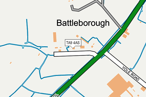
TA9 4AS is located in the Brent electoral ward, within the unitary authority of Somerset and the English Parliamentary constituency of Wells. The Sub Integrated Care Board (ICB) Location is NHS Somerset ICB - 11X and the police force is Avon and Somerset. This postcode has been in use since April 2017.


GetTheData
Source: OS OpenMap – Local (Ordnance Survey)
Source: OS VectorMap District (Ordnance Survey)
Licence: Open Government Licence (requires attribution)
| Easting | 334287 |
| Northing | 150184 |
| Latitude | 51.247021 |
| Longitude | -2.942869 |
GetTheData
Source: Open Postcode Geo
Licence: Open Government Licence
| Country | England |
| Postcode District | TA9 |
| ➜ TA9 open data dashboard ➜ See where TA9 is on a map ➜ Where is Battleborough? | |
GetTheData
Source: Land Registry Price Paid Data
Licence: Open Government Licence
| Ward | Brent |
| Constituency | Wells |
GetTheData
Source: ONS Postcode Database
Licence: Open Government Licence
| June 2022 | Other theft | On or near Petrol Station | 381m |
| May 2022 | Violence and sexual offences | On or near Petrol Station | 381m |
| April 2022 | Public order | On or near Bristol Road | 180m |
| ➜ Get more crime data in our Crime section | |||
GetTheData
Source: data.police.uk
Licence: Open Government Licence
| Goat House (Bristol Road) | Battleborough | 230m |
| Goat House (Bristol Road) | Battleborough | 236m |
| White Cross (Bristol Road) | White Cross | 377m |
| Fox And Goose (Bristol Road) | White Cross | 407m |
| White Cross (Brent Street) | White Cross | 445m |
| Highbridge & Burnham-on-Sea Station | 3.8km |
GetTheData
Source: NaPTAN
Licence: Open Government Licence
| Percentage of properties with Next Generation Access | 0.0% |
| Percentage of properties with Superfast Broadband | 0.0% |
| Percentage of properties with Ultrafast Broadband | 0.0% |
| Percentage of properties with Full Fibre Broadband | 0.0% |
Superfast Broadband is between 30Mbps and 300Mbps
Ultrafast Broadband is > 300Mbps
| Percentage of properties unable to receive 2Mbps | 0.0% |
| Percentage of properties unable to receive 5Mbps | 0.0% |
| Percentage of properties unable to receive 10Mbps | 0.0% |
| Percentage of properties unable to receive 30Mbps | 100.0% |
GetTheData
Source: Ofcom
Licence: Ofcom Terms of Use (requires attribution)
GetTheData
Source: ONS Postcode Database
Licence: Open Government Licence


➜ Get more ratings from the Food Standards Agency
GetTheData
Source: Food Standards Agency
Licence: FSA terms & conditions
| Last Collection | |||
|---|---|---|---|
| Location | Mon-Fri | Sat | Distance |
| Old East Brent Post Office | 11:30 | 10:30 | 1,484m |
| Love Lane | 17:00 | 12:00 | 2,495m |
| Sedgemoor Services | 16:00 | 07:30 | 2,964m |
GetTheData
Source: Dracos
Licence: Creative Commons Attribution-ShareAlike
| Facility | Distance |
|---|---|
| Rossholme Country Holidays (Closed) East Brent, Highbridge Swimming Pool | 1.6km |
| Fusion Leisure Centre Edithmead, Highbridge Health and Fitness Gym, Swimming Pool | 1.8km |
| Burnham Golf Range Bristol Road, Highbridge Golf | 1.9km |
GetTheData
Source: Active Places
Licence: Open Government Licence
| School | Phase of Education | Distance |
|---|---|---|
| Brent Knoll Church of England Primary School Brent Knoll Primary School, Brent Street, Brent Knoll, Highbridge, TA9 4EQ | Primary | 905m |
| East Brent Church of England First School Church Road, East Brent, Highbridge, TA9 4HZ | Primary | 1.8km |
| Burnham-On-Sea Community Infant School Winchester Road, Burnham-on-Sea, TA8 1JD | Primary | 3.1km |
GetTheData
Source: Edubase
Licence: Open Government Licence
| Risk of TA9 4AS flooding from rivers and sea | Low |
| ➜ TA9 4AS flood map | |
GetTheData
Source: Open Flood Risk by Postcode
Licence: Open Government Licence
The below table lists the International Territorial Level (ITL) codes (formerly Nomenclature of Territorial Units for Statistics (NUTS) codes) and Local Administrative Units (LAU) codes for TA9 4AS:
| ITL 1 Code | Name |
|---|---|
| TLK | South West (England) |
| ITL 2 Code | Name |
| TLK2 | Dorset and Somerset |
| ITL 3 Code | Name |
| TLK23 | Somerset CC |
| LAU 1 Code | Name |
| E07000188 | Sedgemoor |
GetTheData
Source: ONS Postcode Directory
Licence: Open Government Licence
The below table lists the Census Output Area (OA), Lower Layer Super Output Area (LSOA), and Middle Layer Super Output Area (MSOA) for TA9 4AS:
| Code | Name | |
|---|---|---|
| OA | E00148426 | |
| LSOA | E01029140 | Sedgemoor 002F |
| MSOA | E02006062 | Sedgemoor 002 |
GetTheData
Source: ONS Postcode Directory
Licence: Open Government Licence
| TA9 4HJ | Bristol Road | 257m |
| TA9 4DU | Brent Street | 413m |
| TA9 4DS | Battleborough Lane | 537m |
| TA9 4EL | Portland Place | 558m |
| TA9 4DT | Brent Street | 559m |
| TA9 4HG | Bristol Road | 651m |
| TA9 4ED | Coombe Side | 706m |
| TA9 4EB | Brent Close | 711m |
| TA9 4EA | East Ride | 731m |
| TA9 4DZ | Manor Ride | 761m |
GetTheData
Source: Open Postcode Geo; Land Registry Price Paid Data
Licence: Open Government Licence