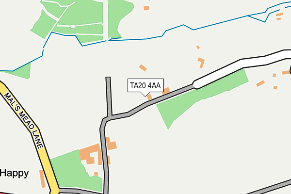
TA20 4AA is in Lydmarsh, Chard. TA20 4AA is located in the Ilminster electoral ward, within the unitary authority of Somerset and the English Parliamentary constituency of Yeovil. The Sub Integrated Care Board (ICB) Location is NHS Somerset ICB - 11X and the police force is Avon and Somerset. This postcode has been in use since January 1980.


GetTheData
Source: OS OpenMap – Local (Ordnance Survey)
Source: OS VectorMap District (Ordnance Survey)
Licence: Open Government Licence (requires attribution)
| Easting | 335410 |
| Northing | 108828 |
| Latitude | 50.875315 |
| Longitude | -2.919381 |
GetTheData
Source: Open Postcode Geo
Licence: Open Government Licence
| Locality | Lydmarsh |
| Town/City | Chard |
| Country | England |
| Postcode District | TA20 |
➜ See where TA20 is on a map | |
GetTheData
Source: Land Registry Price Paid Data
Licence: Open Government Licence
Elevation or altitude of TA20 4AA as distance above sea level:
| Metres | Feet | |
|---|---|---|
| Elevation | 140m | 459ft |
Elevation is measured from the approximate centre of the postcode, to the nearest point on an OS contour line from OS Terrain 50, which has contour spacing of ten vertical metres.
➜ How high above sea level am I? Find the elevation of your current position using your device's GPS.
GetTheData
Source: Open Postcode Elevation
Licence: Open Government Licence
| Ward | Ilminster |
| Constituency | Yeovil |
GetTheData
Source: ONS Postcode Database
Licence: Open Government Licence
| Whatlet Turn | Lydmarsh | 302m |
| Whatley Turn | Lydmarsh | 314m |
| Wreath Turn | Lydmarsh | 596m |
| Wreath Turn | Lydmarsh | 605m |
| The Drift (A30) | Lydmarsh | 946m |
GetTheData
Source: NaPTAN
Licence: Open Government Licence
| Percentage of properties with Next Generation Access | 100.0% |
| Percentage of properties with Superfast Broadband | 0.0% |
| Percentage of properties with Ultrafast Broadband | 0.0% |
| Percentage of properties with Full Fibre Broadband | 0.0% |
Superfast Broadband is between 30Mbps and 300Mbps
Ultrafast Broadband is > 300Mbps
| Percentage of properties unable to receive 2Mbps | 0.0% |
| Percentage of properties unable to receive 5Mbps | 0.0% |
| Percentage of properties unable to receive 10Mbps | 100.0% |
| Percentage of properties unable to receive 30Mbps | 100.0% |
GetTheData
Source: Ofcom
Licence: Ofcom Terms of Use (requires attribution)
GetTheData
Source: ONS Postcode Database
Licence: Open Government Licence


➜ Get more ratings from the Food Standards Agency
GetTheData
Source: Food Standards Agency
Licence: FSA terms & conditions
| Last Collection | |||
|---|---|---|---|
| Location | Mon-Fri | Sat | Distance |
| Whatley | 10:00 | 09:00 | 2,112m |
| Whitegate | 10:00 | 08:15 | 2,319m |
| Thorndun Park | 16:30 | 12:00 | 2,759m |
GetTheData
Source: Dracos
Licence: Creative Commons Attribution-ShareAlike
The below table lists the International Territorial Level (ITL) codes (formerly Nomenclature of Territorial Units for Statistics (NUTS) codes) and Local Administrative Units (LAU) codes for TA20 4AA:
| ITL 1 Code | Name |
|---|---|
| TLK | South West (England) |
| ITL 2 Code | Name |
| TLK2 | Dorset and Somerset |
| ITL 3 Code | Name |
| TLK23 | Somerset CC |
| LAU 1 Code | Name |
| E07000189 | South Somerset |
GetTheData
Source: ONS Postcode Directory
Licence: Open Government Licence
The below table lists the Census Output Area (OA), Lower Layer Super Output Area (LSOA), and Middle Layer Super Output Area (MSOA) for TA20 4AA:
| Code | Name | |
|---|---|---|
| OA | E00148898 | |
| LSOA | E01029230 | South Somerset 024D |
| MSOA | E02006098 | South Somerset 024 |
GetTheData
Source: ONS Postcode Directory
Licence: Open Government Licence
| TA20 4BT | 283m | |
| TA20 4AB | 287m | |
| TA20 4AD | 359m | |
| TA20 4AF | 500m | |
| TA20 4DU | Kingston Well Lane | 571m |
| TA20 4DR | Crewkerne Road | 597m |
| TA20 4BU | 667m | |
| TA20 4AQ | 800m | |
| TA20 4BX | Higher Kingstonwell | 998m |
| TA20 4DL | Crewkerne Road | 1049m |
GetTheData
Source: Open Postcode Geo; Land Registry Price Paid Data
Licence: Open Government Licence