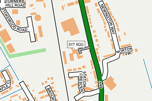
SY7 9QG is located in the Church Stretton and Craven Arms electoral ward, within the unitary authority of Shropshire and the English Parliamentary constituency of Ludlow. The Sub Integrated Care Board (ICB) Location is NHS Shropshire, Telford and Wrekin ICB - M2L0M and the police force is West Mercia. This postcode has been in use since September 2003.


GetTheData
Source: OS OpenMap – Local (Ordnance Survey)
Source: OS VectorMap District (Ordnance Survey)
Licence: Open Government Licence (requires attribution)
| Easting | 343191 |
| Northing | 283249 |
| Latitude | 52.444238 |
| Longitude | -2.837219 |
GetTheData
Source: Open Postcode Geo
Licence: Open Government Licence
| Country | England |
| Postcode District | SY7 |
➜ See where SY7 is on a map ➜ Where is Craven Arms? | |
GetTheData
Source: Land Registry Price Paid Data
Licence: Open Government Licence
Elevation or altitude of SY7 9QG as distance above sea level:
| Metres | Feet | |
|---|---|---|
| Elevation | 120m | 394ft |
Elevation is measured from the approximate centre of the postcode, to the nearest point on an OS contour line from OS Terrain 50, which has contour spacing of ten vertical metres.
➜ How high above sea level am I? Find the elevation of your current position using your device's GPS.
GetTheData
Source: Open Postcode Elevation
Licence: Open Government Licence
| Ward | Church Stretton And Craven Arms |
| Constituency | Ludlow |
GetTheData
Source: ONS Postcode Database
Licence: Open Government Licence
| Royal Mail Offices (A49) | Craven Arms | 116m |
| No. 19 (Newington Way) | Craven Arms | 151m |
| Community Centre (Shrewsbury Road) | Craven Arms | 161m |
| Community Centre (Shrewsbury Road) | Craven Arms | 168m |
| Railway Station (Station Road) | Craven Arms | 173m |
| Craven Arms Station | 0.2km |
| Broome Station | 4km |
GetTheData
Source: NaPTAN
Licence: Open Government Licence
GetTheData
Source: ONS Postcode Database
Licence: Open Government Licence


➜ Get more ratings from the Food Standards Agency
GetTheData
Source: Food Standards Agency
Licence: FSA terms & conditions
| Last Collection | |||
|---|---|---|---|
| Location | Mon-Fri | Sat | Distance |
| Stokesay Bridge | 11:00 | 11:00 | 1,484m |
| Wistanstow | 16:30 | 09:00 | 2,084m |
GetTheData
Source: Dracos
Licence: Creative Commons Attribution-ShareAlike
The below table lists the International Territorial Level (ITL) codes (formerly Nomenclature of Territorial Units for Statistics (NUTS) codes) and Local Administrative Units (LAU) codes for SY7 9QG:
| ITL 1 Code | Name |
|---|---|
| TLG | West Midlands (England) |
| ITL 2 Code | Name |
| TLG2 | Shropshire and Staffordshire |
| ITL 3 Code | Name |
| TLG22 | Shropshire |
| LAU 1 Code | Name |
| E06000051 | Shropshire |
GetTheData
Source: ONS Postcode Directory
Licence: Open Government Licence
The below table lists the Census Output Area (OA), Lower Layer Super Output Area (LSOA), and Middle Layer Super Output Area (MSOA) for SY7 9QG:
| Code | Name | |
|---|---|---|
| OA | E00147762 | |
| LSOA | E01029014 | Shropshire 036D |
| MSOA | E02006043 | Shropshire 036 |
GetTheData
Source: ONS Postcode Directory
Licence: Open Government Licence
| SY7 9NB | Shrewsbury Road | 99m |
| SY7 9QE | Shrewsbury Road | 105m |
| SY7 9RR | Station Crescent | 114m |
| SY7 9QD | Shrewsbury Road | 114m |
| SY7 9PS | Newington Way | 143m |
| SY7 9QF | Shrewsbury Road | 165m |
| SY7 9PU | Newington Way | 174m |
| SY7 9PT | Norton View | 209m |
| SY7 9RL | Brooklands Park | 226m |
| SY7 9PY | Shrewsbury Road | 247m |
GetTheData
Source: Open Postcode Geo; Land Registry Price Paid Data
Licence: Open Government Licence