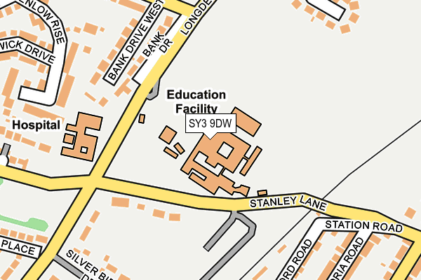
SY3 9DW is located in the Meole electoral ward, within the unitary authority of Shropshire and the English Parliamentary constituency of Shrewsbury and Atcham. The Sub Integrated Care Board (ICB) Location is NHS Shropshire, Telford and Wrekin ICB - M2L0M and the police force is West Mercia. This postcode has been in use since January 1980.


GetTheData
Source: OS OpenMap – Local (Ordnance Survey)
Source: OS VectorMap District (Ordnance Survey)
Licence: Open Government Licence (requires attribution)
| Easting | 348140 |
| Northing | 310785 |
| Latitude | 52.692252 |
| Longitude | -2.768732 |
GetTheData
Source: Open Postcode Geo
Licence: Open Government Licence
| Country | England |
| Postcode District | SY3 |
➜ See where SY3 is on a map ➜ Where is Shrewsbury? | |
GetTheData
Source: Land Registry Price Paid Data
Licence: Open Government Licence
Elevation or altitude of SY3 9DW as distance above sea level:
| Metres | Feet | |
|---|---|---|
| Elevation | 80m | 262ft |
Elevation is measured from the approximate centre of the postcode, to the nearest point on an OS contour line from OS Terrain 50, which has contour spacing of ten vertical metres.
➜ How high above sea level am I? Find the elevation of your current position using your device's GPS.
GetTheData
Source: Open Postcode Elevation
Licence: Open Government Licence
| Ward | Meole |
| Constituency | Shrewsbury And Atcham |
GetTheData
Source: ONS Postcode Database
Licence: Open Government Licence
| Meole Brace School (Longden Road) | Meole Village | 105m |
| Nuffield Hospital (Longden Road) | Meole Village | 165m |
| Nuffield Hospital (Longden Road) | Meole Village | 184m |
| Bank Farm Road Jct (Longden Road) | Radbrook | 212m |
| Bank Drive West Jct (Bank Farm Road) | Radbrook | 253m |
| Shrewsbury Station | 2.5km |
GetTheData
Source: NaPTAN
Licence: Open Government Licence
GetTheData
Source: ONS Postcode Database
Licence: Open Government Licence


➜ Get more ratings from the Food Standards Agency
GetTheData
Source: Food Standards Agency
Licence: FSA terms & conditions
| Last Collection | |||
|---|---|---|---|
| Location | Mon-Fri | Sat | Distance |
| Victoria Road | 18:45 | 11:30 | 291m |
| Meole Hall | 18:45 | 11:30 | 510m |
| Washford Road | 18:45 | 11:30 | 531m |
GetTheData
Source: Dracos
Licence: Creative Commons Attribution-ShareAlike
The below table lists the International Territorial Level (ITL) codes (formerly Nomenclature of Territorial Units for Statistics (NUTS) codes) and Local Administrative Units (LAU) codes for SY3 9DW:
| ITL 1 Code | Name |
|---|---|
| TLG | West Midlands (England) |
| ITL 2 Code | Name |
| TLG2 | Shropshire and Staffordshire |
| ITL 3 Code | Name |
| TLG22 | Shropshire |
| LAU 1 Code | Name |
| E06000051 | Shropshire |
GetTheData
Source: ONS Postcode Directory
Licence: Open Government Licence
The below table lists the Census Output Area (OA), Lower Layer Super Output Area (LSOA), and Middle Layer Super Output Area (MSOA) for SY3 9DW:
| Code | Name | |
|---|---|---|
| OA | E00147498 | |
| LSOA | E01028963 | Shropshire 023D |
| MSOA | E02006037 | Shropshire 023 |
GetTheData
Source: ONS Postcode Directory
Licence: Open Government Licence
| SY3 9DR | Stanley Lane | 120m |
| SY3 9DL | Bank Drive | 156m |
| SY3 9DN | Longden Road | 165m |
| SY3 9DJ | Bank Drive West | 186m |
| SY3 9HR | Washford Road | 221m |
| SY3 6BJ | Henlow Rise | 233m |
| SY3 9EN | Silverbirch Drive | 234m |
| SY3 9EG | Priory Ridge | 234m |
| SY3 9HX | Victoria Road | 252m |
| SY3 9DH | Bank Farm Road | 256m |
GetTheData
Source: Open Postcode Geo; Land Registry Price Paid Data
Licence: Open Government Licence